Difference between revisions of "2011-02-03 52 13"
From Geohashing
imported>Relet (Created page with "{{subst:Expedition/relet}}") |
imported>FippeBot m (Location) |
||
| (5 intermediate revisions by one other user not shown) | |||
| Line 1: | Line 1: | ||
{{meetup graticule | {{meetup graticule | ||
| − | | lat= | + | | lat=52 |
| − | | lon= | + | | lon=13 |
| − | | date= | + | | date=2011-02-03 |
}} | }} | ||
__NOTOC__ | __NOTOC__ | ||
== Location == | == Location == | ||
| + | |||
| + | About 40m from the airstrip of airport SXF, Berlin. | ||
| + | |||
| + | {{PBGH_battleship|lat=52|lon=13|date=2011-02-03}} | ||
== Participants == | == Participants == | ||
| + | |||
| + | * [[User:relet|relet]] | ||
== Plans == | == Plans == | ||
| + | |||
| + | * Land on the airstrip. | ||
== Expedition == | == Expedition == | ||
| + | |||
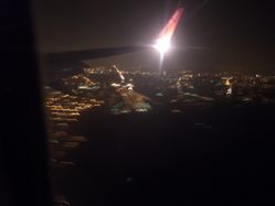
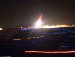
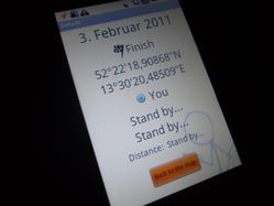
| + | * Landed on the airstrip. I had originally planned to record a tracklog to see how close I have come to the hash, but the GPS did not get a good fix after coming closer to the Earth. So all I can claim is that we have landed from the East, rolled past the geohash, and then took a right turn onto the next taxiway. So we should have passed the hash by about 40m. That's pretty good for a hash on an airfield, but not really within uncertainty limits. | ||
== Tracklog == | == Tracklog == | ||
| + | |||
| + | None. But [http://www.everytrail.com/view_trip.php?trip_id=44569 here's] a tracklog of a flight in the opposite direction on another day. | ||
== Photos == | == Photos == | ||
| Line 21: | Line 33: | ||
{{#vardefine:gaLines|2}} | {{#vardefine:gaLines|2}} | ||
{{Gallery2| | {{Gallery2| | ||
| − | + | {{GalleryItem | File:2011-02-03_52_13_R1062170.JPG | Would be an admit one and restricted area - if reached }} | |
| + | {{GalleryItem | File:2011-02-03_52_13_R1062173.JPG | Approaching }} | ||
| + | {{GalleryItem | File:2011-02-03_52_13_R1062175.JPG | Landed - I was seated on the wrong window, too }} | ||
| + | {{GalleryItem | File:2011-02-03_52_13_R1062177.JPG | No fix }} | ||
}} | }} | ||
| Line 27: | Line 42: | ||
{{#vardefine:ribbonwidth|800px}} | {{#vardefine:ribbonwidth|800px}} | ||
| − | |||
| − | |||
| − | |||
| − | |||
| − | |||
| − | |||
[[Category:Expeditions]] | [[Category:Expeditions]] | ||
| − | |||
[[Category:Expeditions with photos]] | [[Category:Expeditions with photos]] | ||
| − | |||
| − | |||
| − | |||
| − | |||
[[Category:Coordinates not reached]] | [[Category:Coordinates not reached]] | ||
| − | |||
| − | |||
[[Category:Not reached - No public access]] | [[Category:Not reached - No public access]] | ||
| − | + | {{location|DE|BB|LDS}} | |
| − | |||
| − | |||
Latest revision as of 05:26, 9 August 2019
| Thu 3 Feb 2011 in 52,13: 52.3719191, 13.5056903 geohashing.info google osm bing/os kml crox |
Location
About 40m from the airstrip of airport SXF, Berlin.
Today's battleship location is: F 4
Participants
Plans
- Land on the airstrip.
Expedition
- Landed on the airstrip. I had originally planned to record a tracklog to see how close I have come to the hash, but the GPS did not get a good fix after coming closer to the Earth. So all I can claim is that we have landed from the East, rolled past the geohash, and then took a right turn onto the next taxiway. So we should have passed the hash by about 40m. That's pretty good for a hash on an airfield, but not really within uncertainty limits.
Tracklog
None. But here's a tracklog of a flight in the opposite direction on another day.
Photos
|


