Difference between revisions of "2011-02-07 52 13"
From Geohashing
imported>Mampfred |
imported>FippeBot m (Location) |
||
| (One intermediate revision by one other user not shown) | |||
| Line 26: | Line 26: | ||
--> | --> | ||
<gallery perrow="5"> | <gallery perrow="5"> | ||
| + | Image:2011-02-07_52_13_coordinates.jpg | Coordinates ... | ||
| + | Image:2011-02-07_52_13_reached.jpg | ... reached. | ||
| + | Image:2011-02-07_52_13_grin.jpg | Stupid grin | ||
</gallery> | </gallery> | ||
| Line 46: | Line 49: | ||
[[Category:Expeditions with photos]] | [[Category:Expeditions with photos]] | ||
[[Category:Coordinates reached]] | [[Category:Coordinates reached]] | ||
| + | {{location|DE|BB|LDS}} | ||
Latest revision as of 05:30, 9 August 2019
| Mon 7 Feb 2011 in 52,13: 52.2238336, 13.7515688 geohashing.info google osm bing/os kml crox |
Location
Near a little track in the woods.
Participants
- Mampfred and a drag-along Daniel
Plans
Go there after work for a quick hash and get something to eat afterwards.
Expedition
Very easy hash, went most of the way by car, then decided to walk the last km to get some exercise (and the streets were terrible to drive). 50 meters into the woods - coordinates reached.
Tracklog
See here.
Photos
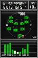
Coordinates ...
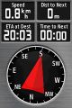
... reached.
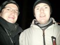
Stupid grin


Achievements
Mampfred earned the Drag-along achievement
|
Mampfred earned the Land geohash achievement
|