Difference between revisions of "2011-02-19 49 13"
From Geohashing
imported>Fabiancz |
m (Location correction) |
||
| (5 intermediate revisions by 4 users not shown) | |||
| Line 1: | Line 1: | ||
{{meetup graticule | {{meetup graticule | ||
| − | + | ||
| lat=49 | | lat=49 | ||
| lon=13 | | lon=13 | ||
| Line 7: | Line 7: | ||
== Location == | == Location == | ||
| − | Quiet location on the field | + | Near Lnare, Chech Republic |
| + | |||
| + | Quiet location on the field surrounded by forest. | ||
| + | |||
| + | ==Participants == | ||
| + | * [[User:fabiancz|fabiancz]] | ||
| + | * [[User:trapperscz|trapperscz]] | ||
== Expedition == | == Expedition == | ||
| − | + | Snow was everywhere. | |
| − | We went from road 177 directly by GPS arrow (for ~750m) - it was quite simple:). | + | |
| + | We went from road 177 directly by GPS arrow (for ~750m) - it was quite simple. :) | ||
| + | |||
| + | == Photos == | ||
| + | <gallery> | ||
| + | Image:fabiancz-2011-02-19_1.jpg|View from place | ||
| + | Image:fabiancz-2011-02-19_2.jpg|Info for other geohashers:) | ||
| + | </gallery> | ||
| + | |||
| + | == Achievements == | ||
| + | * Land Geohash? | ||
| + | * Frozen Geohash? | ||
| + | |||
[[Category:Expeditions]] | [[Category:Expeditions]] | ||
[[Category:Coordinates reached]] | [[Category:Coordinates reached]] | ||
| + | {{location|CZ|PL|4}} | ||
Latest revision as of 20:06, 16 May 2020
| Sat 19 Feb 2011 in 49,13: 49.4659988, 13.7658674 geohashing.info google osm bing/os kml crox |
Location
Near Lnare, Chech Republic
Quiet location on the field surrounded by forest.
Participants
Expedition
Snow was everywhere.
We went from road 177 directly by GPS arrow (for ~750m) - it was quite simple. :)
Photos
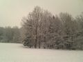
View from place
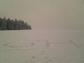
Info for other geohashers:)


Achievements
- Land Geohash?
- Frozen Geohash?