Difference between revisions of "2011-02-26 47 7"
imported>TheOneRing |
imported>FippeBot m (Location) |
||
| (One intermediate revision by one other user not shown) | |||
| Line 39: | Line 39: | ||
{{Public transport geohash | latitude = 47 | longitude = 7 | date = 2011-02-26 | name = TheOneRing}} | {{Public transport geohash | latitude = 47 | longitude = 7 | date = 2011-02-26 | name = TheOneRing}} | ||
{{Border geohash achievement | latitude = 47 | longitude = 7 | date = 2011-02-26 | country1= Switzerland | country2= France | name = TheOneRing }} | {{Border geohash achievement | latitude = 47 | longitude = 7 | date = 2011-02-26 | country1= Switzerland | country2= France | name = TheOneRing }} | ||
| + | The name of the city sounds quite common, so I issued a [[A Tale of Two Hashes achievement|A Tale of Two Hashes]] challenge: | ||
| + | {{A Tale of Two Hashes challenge | latitude = 47 | longitude = 7 | date = 2011-02-26 | name = [[User:TheOneRing|TheOneRing]] | place = [http://en.wikipedia.org/wiki/Saint-Louis Saint-Louis] | image = 20110226Grenze3.jpg | ||
| + | }} | ||
| + | |||
I want to mention here that this was the second region (on country level) I visited in this graticule. When I will visit one geohash in Germany lying in this graticule, I will get the [[Reverse regional achievement]]. | I want to mention here that this was the second region (on country level) I visited in this graticule. When I will visit one geohash in Germany lying in this graticule, I will get the [[Reverse regional achievement]]. | ||
| Line 45: | Line 49: | ||
[[Category:Expeditions with photos]] | [[Category:Expeditions with photos]] | ||
[[Category:Coordinates reached]] | [[Category:Coordinates reached]] | ||
| + | {{location|FR|68}} | ||
Latest revision as of 05:39, 9 August 2019
| Sat 26 Feb 2011 in 47,7: 47.5847362, 7.5654490 geohashing.info google osm bing/os kml crox |
Contents
Location
The geohash is in Saint-Louis (FR) near Basel (SUI) close to the border.
Who Went
TheOneRing - by public transport.
The Expedition
TheOneRing
Today the geohash in this graticule was located in Saint-Louis. This village lies in France, even though only 1 km from the border SUI <-> FR. Even the border FR <-> GER was only approx. 2 km away, as the bird flies.
I went to Basel by train and made a small tour through the city. Well, it was not an indirect way, because I had to cross the city to the border. Like nearly everywhere nowadays in Europe crossing the border was not a problem, I did not have to show my passport or ID card and even could take some photos.
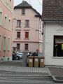
The village of Saint-Louis was quite nice. Unfortunately, the geohash itself was located on a parking lot in private property, but I ignored the sign for once. I did not see anyone to ask for permission but to avoid any trouble I took only the required photos and left.
I walked back to Basel and chose a differnt way in Basel to visit the cathedral. In the end I took a train back to Berne.
Photos
TheOneRing
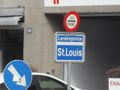
City limit sign of Basel directing to the border
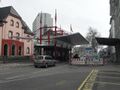
Custom house, the border itself
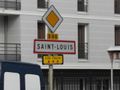
Entering now: Saint-Louis
The geohash was in front of the silver car
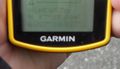
Proof that I reached the right coordinates...
...on the right date

Obligatory self shot
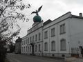
Museum of the amaro "Fernet-Branca"
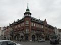
One of the nice buildings in Saint-Louis, here a hotel
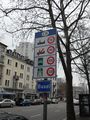
Drive carefully in Switzerland!
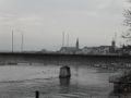
Skyline of Basel, the cathedral in the centre


Achievements
TheOneRing earned the Land geohash achievement
|
TheOneRing earned the Public transport geohash achievement
|
TheOneRing earned the Border geohash achievement
|
The name of the city sounds quite common, so I issued a A Tale of Two Hashes challenge:

I want to mention here that this was the second region (on country level) I visited in this graticule. When I will visit one geohash in Germany lying in this graticule, I will get the Reverse regional achievement.