Difference between revisions of "2011-03-11 48 8"
imported>Koepfel |
imported>FippeBot m (Location) |
||
| Line 34: | Line 34: | ||
[[Category:Expeditions with photos]] | [[Category:Expeditions with photos]] | ||
[[Category:Coordinates reached]] | [[Category:Coordinates reached]] | ||
| + | {{location|DE|BW|RA}} | ||
Latest revision as of 05:47, 9 August 2019
| Fri 11 Mar 2011 in 48,8: 48.7840587, 8.3178434 geohashing.info google osm bing/os kml crox |
Contents
Location
On a field between Ottenau and Selbach, both part of Gaggenau.
Participants
Expedition
Koepfel
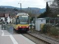
Today, the hashpoint was somewhere in the black forest, between Ottenau and Selbach. Ottenau has a train stop, with the S41 going there directly from Karlsruhe, which I took. From the stop, it was about 2 kilometers by foot to the hashpoint. There also would have been a bus directly to Selbach, probably resulting in a shorter walk, but it didn't seem to be well synchronised with the train, so I walked. Through Ottenau and from there next to a (a) steep and (b) rather busy road with fast cars and no real sidewalk.
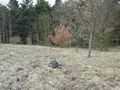
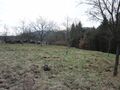
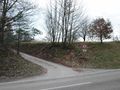
At the hashpoint I arrived at 15:20. Yet another grass field, right next to the road, so hoping to catch the next S41 back, I returned to Ottenau.
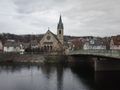
Church in Ottenau
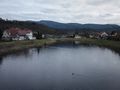
The Murg river
90° time.
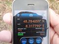
Found it.