Difference between revisions of "2011-03-20 52 -1"
imported>Sourcerer |
imported>Sourcerer |
||
| Line 1: | Line 1: | ||
| − | |||
| − | |||
| − | |||
| − | |||
{{meetup graticule | {{meetup graticule | ||
| lat=52 | | lat=52 | ||
| Line 8: | Line 4: | ||
| date=2011-03-20 | | date=2011-03-20 | ||
| graticule_name=Birmingham | | graticule_name=Birmingham | ||
| − | | graticule_link=Birmingham, United Kingdom}} | + | | graticule_link=Birmingham, United Kingdom |
| + | }} | ||
| + | |||
| + | == Location == | ||
| + | |||
| + | Multihash 2 of 5. In a field about five miles west of Coventry, UK. | ||
== Participants == | == Participants == | ||
| Line 20: | Line 21: | ||
== Photo Gallery == | == Photo Gallery == | ||
| − | <gallery | + | <gallery> |
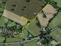
Image:2011-03-20_Sourcerer.jpg|Google Earth View of the 599km Journey | Image:2011-03-20_Sourcerer.jpg|Google Earth View of the 599km Journey | ||
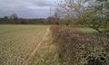
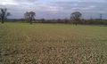
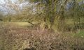
Image:2011-03-20 52 -1 Sourcerer 1.jpg|The Hashpoint | Image:2011-03-20 52 -1 Sourcerer 1.jpg|The Hashpoint | ||
| Line 47: | Line 48: | ||
}} | }} | ||
| + | [[Category:Expeditions]] | ||
[[Category:Expeditions with photos]] | [[Category:Expeditions with photos]] | ||
[[Category:Coordinates reached]] | [[Category:Coordinates reached]] | ||
| − | |||
| − | |||
Revision as of 15:19, 22 August 2012
| Sun 20 Mar 2011 in Birmingham: 52.3877725, -1.6268758 geohashing.info google osm bing/os kml crox |
Contents
Location
Multihash 2 of 5. In a field about five miles west of Coventry, UK.
Participants
Expedition
This was hash two of five on a 599 km journey. Driving to the hashpoint was tricky because it was surrounded by big cities and motorways. After driving to the dead end of a huge industrial estate north of Coventry Neil eventually found a route avoiding the city centre. The walk to the hashpoint was only 1.6 km on a public footpath. The point was located in a field on the wrong side of a thick prickly hedge so a small trespass was needed through a gate and a gap in a second hedge. There were no "no entry" signs and it was possible to reach the hash without crop damage. This was a pleasant spot surrounded by major urban areas.
Photo Gallery
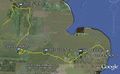
Google Earth View of the 599km Journey
The Hashpoint
The Hashpoint
The Hashpoint
Google Earth View of the Walk


Other Geohashing Expeditions and Plans on This Day
Expeditions and Plans
| 2011-03-20 | ||
|---|---|---|
| Varna, Bulgaria | Kisolre | In a ex corn field near Voivodino village. |
| Mannheim, Germany | ilpadre, fivetonsofflax, Euterkuh, Mampfred, LadyBB | In a field south of Eppelheim. |
| Schweinfurt, Germany | Reinhard | On a field at the foot of the "Großen Gleichberg" (big equal mountain). |
| Halle (Saale), Germany | Rincewind, Yakamoz | For a change, the hashpoint was on a field near Querfurt. |
| Northampton, United Kingdom | Sourcerer | Multihash 3 of 5. In a field at Twywell Hills and Dales, about 4.5 miles ea... |
| Birmingham, United Kingdom | Sourcerer | Multihash 2 of 5. In a field about five miles west of Coventry, UK. 2011-03-20 53 -1 ::2011-03-20 52 -1 ::... |
| Cambridge, United Kingdom | Sourcerer | Multihash 4 of 5. In a field about a mile west of the Elveden Center Parcs ... |
| Norwich, United Kingdom | Sourcerer | Multihash 5 of 5. In a field north west of Frostenden, two miles west of Wr... |
| Sheffield, United Kingdom | Sourcerer | Multihash 1 of 5. In a field north of the A57 at Hollow Meadows about seven... |
| Vantaa, Finland | small oaks | The coordinates were in a private yard roughly 50 m off the spot I managed ... |
Achievements
Sourcerer achieved level 7 of the Minesweeper Geohash achievement
|