Difference between revisions of "2011-03-22 52 1"
From Geohashing
imported>Sourcerer m |
imported>Jiml m (Tweat format) |
||
| Line 20: | Line 20: | ||
== Photo Gallery == | == Photo Gallery == | ||
| − | <gallery perrow=" | + | <gallery perrow="2"> |
Image:2011-03-22_52_1_Sourcerer_1.jpg|Google Earth View of the Hashpoint | Image:2011-03-22_52_1_Sourcerer_1.jpg|Google Earth View of the Hashpoint | ||
Image:2011-03-22_52_1_Sourcerer_2.jpg|The Hashpoint | Image:2011-03-22_52_1_Sourcerer_2.jpg|The Hashpoint | ||
| Line 32: | Line 32: | ||
[[Category:Expeditions with photos]] | [[Category:Expeditions with photos]] | ||
[[Category:Coordinates reached]] | [[Category:Coordinates reached]] | ||
| − | |||
| − | |||
Revision as of 14:48, 4 April 2011
Contents
Location
By the edge of a field 1000 metres north of St Margaret, South Elmham, Suffolk, UK.
| Tue 22 Mar 2011 in Norwich: 52.4149352, 1.4016354 geohashing.info google osm bing/os kml crox |
Participants
Expedition
The hashpoint was a few miles from Neil's home and next to the road. There was a parking place nearby. A wet drainage ditch ran between the road and the field but there was easy access on foot at the south end of the field. The hashpoint was a few paces into the field near a mature tree.
Photo Gallery
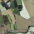
Google Earth View of the Hashpoint
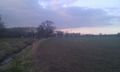
The Hashpoint
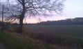
The Hashpoint


Other Geohashing Expeditions and Plans on This Day
Expeditions and Plans
| 2011-03-22 | ||
|---|---|---|
| Atlanta, Georgia | NWoodruff | In the back lot of an apartment complex in Stone Mountain |
| Norwich, United Kingdom | Sourcerer | By the edge of a field 1000 metres north of St Margaret, South Elmham, Suff... |
| Sheffield, United Kingdom | Monty | Google Maps says the hashpoint is on a 'bridge' (actually a pipeline) going... |
| Rovaniemi, Finland | isopekka | 20 km to the SW from the city Rovaniemi, exactly on the railway! |