Difference between revisions of "2011-04-08 53 -1"
imported>Monty m (Here we go again. Must watch what I type/copy.) |
m (Location correction) |
||
| (2 intermediate revisions by 2 users not shown) | |||
| Line 1: | Line 1: | ||
| + | [[Image:{{{image|2011-04-08_53_-1_HashTreeGuessAndMe.png}}}|thumb|left]] | ||
| − | |||
| − | |||
| − | |||
| − | |||
| − | |||
| − | |||
| − | |||
| − | |||
| − | |||
{{meetup graticule | {{meetup graticule | ||
| lat=53 | | lat=53 | ||
| Line 15: | Line 7: | ||
}} | }} | ||
| − | |||
__NOTOC__ | __NOTOC__ | ||
== Location == | == Location == | ||
| − | + | In the middle of Castle Hills Woods, nr Micklefield, Leeds area | |
== Participants == | == Participants == | ||
| − | + | [[User:Monty|Monty]] | |
== Plans == | == Plans == | ||
| − | + | Snap decision. Location looked up, assessed as possibly to reach and (in the absence of a printer) a photo taken of the screen to be used as a guide to narrowing down the point in No Batteries mode. | |
== Expedition == | == Expedition == | ||
| − | + | Time and location allowed a late-in-the-day trip to the area. Some quick research was made. Technically, this should be under "Plans", but as it was done almost immediately before leaving, I count it as part of the Expedition itself. | |
| + | |||
| + | Google Maps and Streetview had shown that an apparent footpath left the Great North Road near the "Micklefields" (Micklefield itself, with Old Micklefield to the north and New Micklefield to the south, as was the path). Streetview shots from the A1(M) showed that the path involved goes underneath the motorway, skirted some area of (at least one time) active forestry clearance, and examination of the overhead maps available again showed that the wooded the path disappeared into had pretty obvious footways through it (a further StreetView check on the roads at eastern side showed a public path emerging from that direction), and moreover the trees were in strict lines, indicating a managed woodland not likely to be so overgrown as to disallow the off-trail travel required to get to the exact point demanded. | ||
| + | |||
| + | Again (sorry, stuck record) Monty is restricted to a No Batteries expedition, so made careful examination of the tree patterns and the point to be aimed at. At a very basic level, there was a corner in the apparent pathway from which striking at in an exactly bisecting angle for a certain number of tree-lines should lead one to the exact location indicated by the electronic overheads. He also (he realised later) had not his traditional Hat, nor the tripod that would help in photos, but by good fortune the now ''also'' traditional large-digit alarm clock was in his possession. For what it was worth, it should 'prove' (or certainly indicate) the time and date of photos. | ||
| + | |||
| + | So, now actually travelling, New Micklefield was approached by taking the A63 (Selby Road) from the direction of Leeds and where it turned southwards and became the Great North Road (the olden-times predecessor to the A1, in this particular neck of the woods). The northward turn up to the less grandly enumerated road (maybe a B-road, perhaps even a C-road... must re-check the maps) was also the Great North Road, and led towards the various Micklefields, but first to the path end required for this expedition. Parking in this gated road-end, it was gratifying to see early-evening perambulators (dog-walkers among them) wandering this way, reassuring one of public access. | ||
| + | |||
| + | Underneath the A1(M), and emerging up the other side, the sound of an aircraft led the eyes to something that appeared to be a motor-glider, climbing into the sky, above the horizon. The photo of which did far more justice to the foreground vegetation than the flying contraption itself. | ||
| + | |||
| + | A far more strange sight was, hung upon railings barring access to a large area (luckily not one I had to be in), the sign "Caution, Students Crossing" (albeit in ALLCAPS and with no punctuation). I would dearly love to know the story behind this rather permanent-looking signage, but hey-ho... | ||
| + | |||
| + | Onwards, however, and skirting the fenced-off (and totally de-treed) area, that held no significant interest for me, the public path entered the woodlands. Closed gate (opened, by the time I re-emerged, later on) for vehicles, a "kissing gate" for pedestrians and an additional passageway suitable for lumbering across (or carefully hopping over) with bikes (both pedal- and motor-), and the only obvious public right-of-way anyway. A very civilised woodland, with the previously recognised regimented lines of trees and well-worn pathways. Travelling eastwards towards the desired corner of the woods, from which the target point could reasonably be aimed for, I came across a signpost indicating Public Footpaths in multiple directions, and all under the name of "Castle Hills" (with likely some history behind that name that would bear looking for, when there is more time). | ||
| + | |||
| + | Less than a hundred yards further on, the path bends recognisably and true to the map. And the tree-laden area continues to be obviously foot-navigable, and so the cross-country trek begins, counting the lines of trees passed through. At this point, I have to be honest, as the best photo opportunity (given we are in the midst of a managed woodland, with much uniformity and anonymity) was ''slightly before'' the number of tree-rows I had memorised that I should have passed through. Given I passed onwards afterwards (and therefore continuing over, or perhaps nearby to one side, of the real geohash point), I'm sure no-one would begrudge me such impreciseness, however. | ||
| + | |||
| + | Alarm clock was placed upon the featured branch of the fallen tree, and the time and date recorded. But without the tripod, how was I to get a photo of myself!?! (''Sans'' hat!) A handy junction between a given tree-branch and its parent trunk was the answer, and a few tense moments commenced while the camera was unsteadily positioned, set for a number of seconds delay and temporarily abandoned to the fates of balance and gravity. Luckily, the said Fates smiled kindly upon the attempt, and (dodgy pose, and so obviously concerned facial expression aside) all was well for the short duration my and my camera's mutual separation. Phew. | ||
| + | |||
| + | Task considered complete, further wandering through wood was actually slightly diverted by the sight of a long-since extinct automotive vehicle, doubtless originally abandoned and burnt out by persons other than the legal owner, but then the journey across the rough tree-litter woodland floor brought me to back upon a more legitimate woodland pathway, to be followed back to the previously discovered sign-post and the rest of the trip merely retraced the entry path, before driving off. Homeward-bound and honour satisfied. | ||
| + | |||
== Tracklog == | == Tracklog == | ||
| − | + | n/a | |
== Photos == | == Photos == | ||
| − | |||
| − | |||
| − | |||
<gallery perrow="5"> | <gallery perrow="5"> | ||
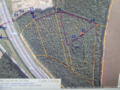
| + | Image:2011-04-08 53 -1 AnnotatedMap.png | The plan and the result | ||
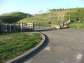
| + | Image:2011-04-08 53 -1 PathEnd.png | The walking begins | ||
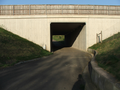
| + | Image:2011-04-08 53 -1 UnderM1.png | Under the A1(M) | ||
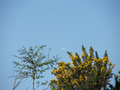
| + | Image:2011-04-08 53 -1 BlurryPlane.png | Nice foreground... | ||
| + | Image:2011-04-08 53 -1 Warning.png | Beware the collegiate! | ||
| + | Image:2011-04-08 53 -1 OtherWarning.png | Not going there, anyway | ||
| + | Image:2011-04-08 53 -1 WoodsEntrance.png | This way | ||
| + | Image:2011-04-08 53 -1 Paths1.png | Easy access | ||
| + | Image:2011-04-08 53 -1 WhereWeAre.png | The name of the place | ||
| + | Image:2011-04-08 53 -1 PathCorner.png | From where to strike out | ||
| + | Image:2011-04-08 53 -1 HashTreeGuess.png | Near as damnit | ||
| + | Image:2011-04-08 53 -1 HashTreeGuessClose.png | A better view of the time | ||
| + | Image:2011-04-08 53 -1 HashTreeGuessAndMe.png | I need to work on that grin | ||
| + | Image:2011-04-08 53 -1 Wreckage1.png | Wrecked... | ||
| + | Image:2011-04-08 53 -1 Wreckage2.png | ...and rusted | ||
</gallery> | </gallery> | ||
== Achievements == | == Achievements == | ||
{{#vardefine:ribbonwidth|800px}} | {{#vardefine:ribbonwidth|800px}} | ||
| − | + | {{land geohash | latitude = 53 | longitude = -1 | date = 2011-04-08 | name = [[User:Monty|Monty]] }} | |
| − | + | {{No_batteries_geohash | latitude = 53 | longitude = -1 | date = 2011-04-08 | name = [[User:Monty|Monty]] | image = 2011-04-08 53 -1 AnnotatedMap.png }} | |
| − | |||
| − | |||
| − | |||
| − | [[ | ||
| − | |||
| − | |||
| − | |||
| − | |||
| − | |||
[[Category:Expeditions]] | [[Category:Expeditions]] | ||
| − | |||
[[Category:Expeditions with photos]] | [[Category:Expeditions with photos]] | ||
| − | |||
[[Category:Expedition without GPS]] | [[Category:Expedition without GPS]] | ||
| − | |||
| − | |||
| − | |||
[[Category:Coordinates reached]] | [[Category:Coordinates reached]] | ||
| − | + | {{location|GB|ENG|LDS}} | |
| − | |||
| − | |||
| − | |||
| − | |||
| − | |||
| − | |||
| − | |||
| − | |||
| − | |||
Latest revision as of 20:07, 16 May 2020

| Fri 8 Apr 2011 in 53,-1: 53.7844344, -1.3156551 geohashing.info google osm bing/os kml crox |
Location
In the middle of Castle Hills Woods, nr Micklefield, Leeds area
Participants
Plans
Snap decision. Location looked up, assessed as possibly to reach and (in the absence of a printer) a photo taken of the screen to be used as a guide to narrowing down the point in No Batteries mode.
Expedition
Time and location allowed a late-in-the-day trip to the area. Some quick research was made. Technically, this should be under "Plans", but as it was done almost immediately before leaving, I count it as part of the Expedition itself.
Google Maps and Streetview had shown that an apparent footpath left the Great North Road near the "Micklefields" (Micklefield itself, with Old Micklefield to the north and New Micklefield to the south, as was the path). Streetview shots from the A1(M) showed that the path involved goes underneath the motorway, skirted some area of (at least one time) active forestry clearance, and examination of the overhead maps available again showed that the wooded the path disappeared into had pretty obvious footways through it (a further StreetView check on the roads at eastern side showed a public path emerging from that direction), and moreover the trees were in strict lines, indicating a managed woodland not likely to be so overgrown as to disallow the off-trail travel required to get to the exact point demanded.
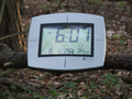
Again (sorry, stuck record) Monty is restricted to a No Batteries expedition, so made careful examination of the tree patterns and the point to be aimed at. At a very basic level, there was a corner in the apparent pathway from which striking at in an exactly bisecting angle for a certain number of tree-lines should lead one to the exact location indicated by the electronic overheads. He also (he realised later) had not his traditional Hat, nor the tripod that would help in photos, but by good fortune the now also traditional large-digit alarm clock was in his possession. For what it was worth, it should 'prove' (or certainly indicate) the time and date of photos.
So, now actually travelling, New Micklefield was approached by taking the A63 (Selby Road) from the direction of Leeds and where it turned southwards and became the Great North Road (the olden-times predecessor to the A1, in this particular neck of the woods). The northward turn up to the less grandly enumerated road (maybe a B-road, perhaps even a C-road... must re-check the maps) was also the Great North Road, and led towards the various Micklefields, but first to the path end required for this expedition. Parking in this gated road-end, it was gratifying to see early-evening perambulators (dog-walkers among them) wandering this way, reassuring one of public access.
Underneath the A1(M), and emerging up the other side, the sound of an aircraft led the eyes to something that appeared to be a motor-glider, climbing into the sky, above the horizon. The photo of which did far more justice to the foreground vegetation than the flying contraption itself.
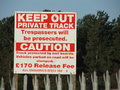
A far more strange sight was, hung upon railings barring access to a large area (luckily not one I had to be in), the sign "Caution, Students Crossing" (albeit in ALLCAPS and with no punctuation). I would dearly love to know the story behind this rather permanent-looking signage, but hey-ho...
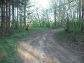
Onwards, however, and skirting the fenced-off (and totally de-treed) area, that held no significant interest for me, the public path entered the woodlands. Closed gate (opened, by the time I re-emerged, later on) for vehicles, a "kissing gate" for pedestrians and an additional passageway suitable for lumbering across (or carefully hopping over) with bikes (both pedal- and motor-), and the only obvious public right-of-way anyway. A very civilised woodland, with the previously recognised regimented lines of trees and well-worn pathways. Travelling eastwards towards the desired corner of the woods, from which the target point could reasonably be aimed for, I came across a signpost indicating Public Footpaths in multiple directions, and all under the name of "Castle Hills" (with likely some history behind that name that would bear looking for, when there is more time).
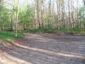
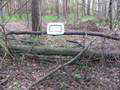
Less than a hundred yards further on, the path bends recognisably and true to the map. And the tree-laden area continues to be obviously foot-navigable, and so the cross-country trek begins, counting the lines of trees passed through. At this point, I have to be honest, as the best photo opportunity (given we are in the midst of a managed woodland, with much uniformity and anonymity) was slightly before the number of tree-rows I had memorised that I should have passed through. Given I passed onwards afterwards (and therefore continuing over, or perhaps nearby to one side, of the real geohash point), I'm sure no-one would begrudge me such impreciseness, however.
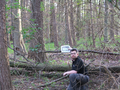
Alarm clock was placed upon the featured branch of the fallen tree, and the time and date recorded. But without the tripod, how was I to get a photo of myself!?! (Sans hat!) A handy junction between a given tree-branch and its parent trunk was the answer, and a few tense moments commenced while the camera was unsteadily positioned, set for a number of seconds delay and temporarily abandoned to the fates of balance and gravity. Luckily, the said Fates smiled kindly upon the attempt, and (dodgy pose, and so obviously concerned facial expression aside) all was well for the short duration my and my camera's mutual separation. Phew.
Task considered complete, further wandering through wood was actually slightly diverted by the sight of a long-since extinct automotive vehicle, doubtless originally abandoned and burnt out by persons other than the legal owner, but then the journey across the rough tree-litter woodland floor brought me to back upon a more legitimate woodland pathway, to be followed back to the previously discovered sign-post and the rest of the trip merely retraced the entry path, before driving off. Homeward-bound and honour satisfied.
Tracklog
n/a
Photos
The plan and the result
The walking begins
Under the A1(M)
Nice foreground...

Beware the collegiate!
Not going there, anyway
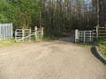
This way
Easy access
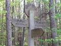
The name of the place
From where to strike out
Near as damnit
A better view of the time
I need to work on that grin
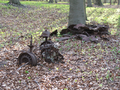
Wrecked...
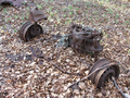
...and rusted


Achievements
Monty earned the Land geohash achievement
|
Monty earned the No Batteries Geohash Achievement
|