Difference between revisions of "2011-04-09 49 -123"
imported>Robyn (Pictures in a sec.) |
imported>Robyn (Plus pictures.) |
||
| Line 20: | Line 20: | ||
It was an expedition almost unVancouverlike in its simplicity. The bus came when it should and went where it was supposed to, as did the bridge, the subsequent trail and the requisite fifteen metres of brambles and uphill. The pictures tell the story. | It was an expedition almost unVancouverlike in its simplicity. The bus came when it should and went where it was supposed to, as did the bridge, the subsequent trail and the requisite fifteen metres of brambles and uphill. The pictures tell the story. | ||
| + | The immediate area was more like a municipal depot for large rocks, earth and shredded trees than a conventional park. We found out from a couple of guys who were sitting on top of a pile of rocks watching a cricket game in a more conventional part of the park that it was reclaimed land from what had been a garbage dump. | ||
== Images == | == Images == | ||
<gallery> | <gallery> | ||
| + | File:2011-04-10 49 -123.seabus.jpg|We connected from a regular bus to the Skytrain to the Seabus, and then back to a regular bus | ||
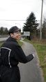
| + | File:2011-04-09 49 -123.bridge.jpg|... before walking across the bridge to the next municipality ... | ||
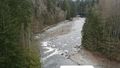
| + | File:2011-04-09 49 -123.capilano.jpg|... over the Capilano River, lower than usual for this time of year, because the cold has delayed mountain snow melt. | ||
| + | File:2011-04-09 49 -123.brambles.jpg|Robyn doing the "don't catch your pants on brambles" dance, | ||
| + | File:2011-04-09 49 -123.gps.jpg|until we found the spot ... | ||
| + | File:2011-04-10 49 -123.xkcd.jpg|... and marked it with a board that was already there. | ||
| + | File:2011-04-09 49 -123.daffodil.jpg|Then we found some daffodils growing out of a clump of dirt that was right on the road. | ||
</gallery> | </gallery> | ||
Revision as of 19:44, 10 April 2011
| Sat 9 Apr 2011 in 49,-123: 49.3338518, -123.1192604 geohashing.info google osm bing/os kml crox |
Location
An accessible forested area in West Vancouver. It's just west of the Capilano River, metres from the access road to a public park.
Participants
Plans
We asked the public transit website how to get there and it didn't know, probably because there are no bus stops nearby in West Vancouver and its calculation didn't allow it to consider the most convenient bus stop, which is in North Vancouver, a different municipality, and across a deep ravine with a river, but we saw a bridge with a pedestrian sidewalk and that was enough planning.
Expedition
It was an expedition almost unVancouverlike in its simplicity. The bus came when it should and went where it was supposed to, as did the bridge, the subsequent trail and the requisite fifteen metres of brambles and uphill. The pictures tell the story.
The immediate area was more like a municipal depot for large rocks, earth and shredded trees than a conventional park. We found out from a couple of guys who were sitting on top of a pile of rocks watching a cricket game in a more conventional part of the park that it was reclaimed land from what had been a garbage dump.
Images

We connected from a regular bus to the Skytrain to the Seabus, and then back to a regular bus
... before walking across the bridge to the next municipality ...
... over the Capilano River, lower than usual for this time of year, because the cold has delayed mountain snow melt.
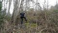
Robyn doing the "don't catch your pants on brambles" dance,
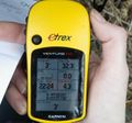
until we found the spot ...
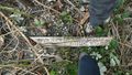
... and marked it with a board that was already there.
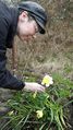
Then we found some daffodils growing out of a clump of dirt that was right on the road.


