Difference between revisions of "2011-04-23 63 18"
imported>Jiml m (Planning!! Yeah!) |
m (per Renaming Proposal) |
||
| (7 intermediate revisions by 2 users not shown) | |||
| Line 1: | Line 1: | ||
| − | |||
| − | |||
| − | |||
| − | |||
| − | |||
| − | |||
| − | |||
| − | |||
| − | |||
{{meetup graticule | {{meetup graticule | ||
| lat=63 | | lat=63 | ||
| Line 14: | Line 5: | ||
}} | }} | ||
| − | |||
__NOTOC__ | __NOTOC__ | ||
== Location == | == Location == | ||
| − | |||
East of Örnsköldsvik on a hill/mountain, in some wooded area. | East of Örnsköldsvik on a hill/mountain, in some wooded area. | ||
| + | |||
| + | For APR's reference: | ||
| + | {{PBGH battleship | lat = 63 | lon = 18 | date=2011-04-23}} | ||
== Participants == | == Participants == | ||
| − | |||
* [[User:Aperfectring|APR]] | * [[User:Aperfectring|APR]] | ||
* APR's coworker | * APR's coworker | ||
== Plans == | == Plans == | ||
| − | |||
Nothing firm, head out and blaze a trail through the still snow-spotted woods to the hashpoint. | Nothing firm, head out and blaze a trail through the still snow-spotted woods to the hashpoint. | ||
== Expedition == | == Expedition == | ||
| − | + | We headed out shortly after lunch. The weather was nice and sunny, and a warm 60F (yes, we are still looking up the weather conditions in US customary measures). We started off by heading to the nearby sports complex, on foot, because we don't have a car or bikes. The hashpoint was surveyed to be somewhere behind the sports complex, and from maps we knew there to be some cross country skiing tracks through the woods. It turned out that one of the tracks (we jumped back and forth between different ones multiple times) brought us to about 1500ft (450m) from the point. Along the way, we caught some very nice views of the surrounding countryside, and trudged through some of the few remaining snowbanks in the area. | |
| + | |||
| + | Stupidity distance meter on! We left the trail, and immediately discovered we were at the top of a ridge, and the slope down was rather steep, uneven, and moss/lichen covered. We slowly, through switchbacking, made our way down the ridge, and got to a clearcut section of the woods. After crossing the clearcut section, we had about 750ft (220m) to go, through what would be fairly dense underbrush, were it only a little bit later in the year. Still, though, we were both surprised at how little of a canopy there was overhead. In Oregon, we would have been out of GPS signal long ago. The last section of traverse was mostly trailblazing, and finding the path of "least resistance" through the trees. We did a bad job at this. Eventually, though, we did make it to the hashpoint. Huzzah! | ||
| + | |||
| + | Switch to the return stupidity distance. We were able to find MUCH better routes back through the brush, and ran across a path/road which let us not have to climb the ridge back up to the top. End return stupidity distance, probably a good 75% of the length of the distance to the hashpoint. After hiking on the trail for a bit, we got back to one of the cross country skiing track, and took it the wrong way. As it turns out, we took it for about a 1.5km loop to get us right back to where we joined up with the track. We then slowly made our way back, trudging through more snow along the way. | ||
== Tracklog == | == Tracklog == | ||
| − | + | [http://www.everytrail.com/view_trip.php?trip_id=1053971 Its here!] | |
== Photos == | == Photos == | ||
| − | <!-- | + | <gallery perrow="4"> |
| − | + | File:2011-04-23 63 18 apr01.JPG | The cross country skiing tracks (not all were paved, but most were) | |
| − | -- | + | File:2011-04-23 63 18 apr02.JPG | The bridge we had to go under to get to the woods |
| − | + | File:2011-04-23 63 18 apr03.JPG | A snow covered skiing track | |
| + | File:2011-04-23 63 18 apr04.JPG | | ||
| + | File:2011-04-23 63 18 apr05.JPG | | ||
| + | File:2011-04-23 63 18 apr06.JPG | | ||
| + | File:2011-04-23 63 18 apr07.JPG | | ||
| + | File:2011-04-23 63 18 apr08.JPG | | ||
| + | File:2011-04-23 63 18 apr09.JPG | A bird feather found along the way | ||
| + | File:2011-04-23 63 18 apr10.JPG | | ||
| + | File:2011-04-23 63 18 apr11.JPG | | ||
| + | File:2011-04-23 63 18 apr12.JPG | A shelter along the skiing track, this is near the top of the ridge we climbed down | ||
| + | File:2011-04-23 63 18 apr13.JPG | | ||
| + | File:2011-04-23 63 18 apr14.JPG | | ||
| + | File:2011-04-23 63 18 apr15.JPG | | ||
| + | File:2011-04-23 63 18 apr16.JPG | | ||
| + | File:2011-04-23 63 18 apr17.JPG | | ||
| + | File:2011-04-23 63 18 apr18.JPG | | ||
| + | File:2011-04-23 63 18 apr19.JPG | | ||
| + | File:2011-04-23 63 18 apr20.JPG | A look back up the ridge we were climbing down | ||
| + | File:2011-04-23 63 18 apr21.JPG | A view across the clearcut area | ||
| + | File:2011-04-23 63 18 apr22.JPG | Another view across the clearcut area | ||
| + | File:2011-04-23 63 18 apr23.JPG | | ||
| + | File:2011-04-23 63 18 apr24.JPG | | ||
| + | File:2011-04-23 63 18 apr25.JPG | The underbrush we walked through | ||
| + | File:2011-04-23 63 18 apr26.JPG | More of the underbrush we walked through | ||
| + | File:2011-04-23 63 18 apr27.JPG | Proof! | ||
| + | File:2011-04-23 63 18 apr28.JPG | APR's coworker | ||
| + | File:2011-04-23 63 18 apr29.JPG | The way back! | ||
| + | File:2011-04-23 63 18 apr30.JPG | Up the hill, and towards the ski tracks! | ||
| + | File:2011-04-23 63 18 apr31.JPG | | ||
| + | File:2011-04-23 63 18 apr32.JPG | The view out from the extra loop we did on the ski track | ||
| + | File:APR Ovik.jpg | APR at the hashpoint! | ||
</gallery> | </gallery> | ||
== Achievements == | == Achievements == | ||
{{#vardefine:ribbonwidth|800px}} | {{#vardefine:ribbonwidth|800px}} | ||
| − | + | {{Walk geohash | latitude = 63 | longitude = 18 | date = 2011-04-23 | name = [[User:Aperfectring|APR]] | distance = 10.5km }} | |
| + | {{drag-along | latitude = 63 | longitude = 18 | date = 2011-04-23 | partner = his coworker | name = [[User:Aperfectring|APR]] }} | ||
| + | {{Graticule unlocked | latitude = 63 | longitude = 18 | date = 2011-04-23 | name = [[User:Aperfectring|APR]] }} | ||
| − | |||
| − | |||
| − | |||
| − | |||
| − | |||
| − | |||
| − | |||
| − | |||
| − | |||
[[Category:Expeditions]] | [[Category:Expeditions]] | ||
| − | |||
[[Category:Expeditions with photos]] | [[Category:Expeditions with photos]] | ||
| − | |||
| − | |||
| − | |||
| − | |||
[[Category:Coordinates reached]] | [[Category:Coordinates reached]] | ||
| − | + | {{location|SE|Y}} | |
| − | |||
| − | |||
| − | |||
| − | |||
| − | |||
| − | |||
| − | |||
| − | |||
| − | |||
Latest revision as of 05:55, 20 March 2024
| Sat 23 Apr 2011 in 63,18: 63.2925429, 18.7866347 geohashing.info google osm bing/os kml crox |
Location
East of Örnsköldsvik on a hill/mountain, in some wooded area.
For APR's reference: Today's battleship location is: H 3
Participants
- APR
- APR's coworker
Plans
Nothing firm, head out and blaze a trail through the still snow-spotted woods to the hashpoint.
Expedition
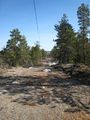
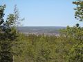
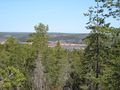
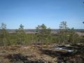
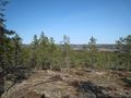
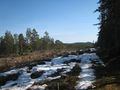
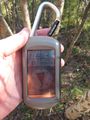
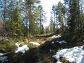
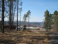
We headed out shortly after lunch. The weather was nice and sunny, and a warm 60F (yes, we are still looking up the weather conditions in US customary measures). We started off by heading to the nearby sports complex, on foot, because we don't have a car or bikes. The hashpoint was surveyed to be somewhere behind the sports complex, and from maps we knew there to be some cross country skiing tracks through the woods. It turned out that one of the tracks (we jumped back and forth between different ones multiple times) brought us to about 1500ft (450m) from the point. Along the way, we caught some very nice views of the surrounding countryside, and trudged through some of the few remaining snowbanks in the area.
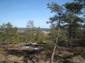
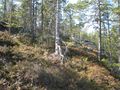
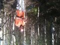
Stupidity distance meter on! We left the trail, and immediately discovered we were at the top of a ridge, and the slope down was rather steep, uneven, and moss/lichen covered. We slowly, through switchbacking, made our way down the ridge, and got to a clearcut section of the woods. After crossing the clearcut section, we had about 750ft (220m) to go, through what would be fairly dense underbrush, were it only a little bit later in the year. Still, though, we were both surprised at how little of a canopy there was overhead. In Oregon, we would have been out of GPS signal long ago. The last section of traverse was mostly trailblazing, and finding the path of "least resistance" through the trees. We did a bad job at this. Eventually, though, we did make it to the hashpoint. Huzzah!
Switch to the return stupidity distance. We were able to find MUCH better routes back through the brush, and ran across a path/road which let us not have to climb the ridge back up to the top. End return stupidity distance, probably a good 75% of the length of the distance to the hashpoint. After hiking on the trail for a bit, we got back to one of the cross country skiing track, and took it the wrong way. As it turns out, we took it for about a 1.5km loop to get us right back to where we joined up with the track. We then slowly made our way back, trudging through more snow along the way.
Tracklog
Photos
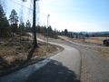
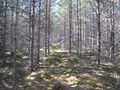
The cross country skiing tracks (not all were paved, but most were)
The bridge we had to go under to get to the woods
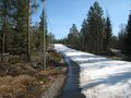
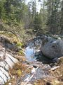
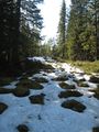
A snow covered skiing track

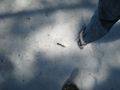
A bird feather found along the way
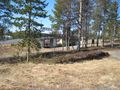
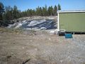
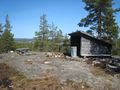
A shelter along the skiing track, this is near the top of the ridge we climbed down
A look back up the ridge we were climbing down
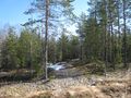
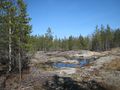
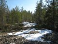
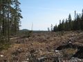
A view across the clearcut area
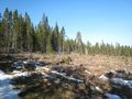
Another view across the clearcut area
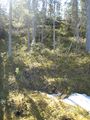
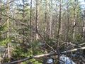
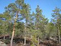
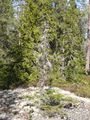
The underbrush we walked through
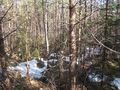
More of the underbrush we walked through
Proof!
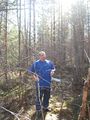
APR's coworker
The way back!
Up the hill, and towards the ski tracks!
The view out from the extra loop we did on the ski track
APR at the hashpoint!


Achievements
APR earned the Walk geohash Achievement
|
APR earned the Drag-along achievement
|
APR earned the Graticule Unlocked Achievement
|