Difference between revisions of "2011-04-27 45 -122"
From Geohashing
imported>Michael5000 m (→Photos) |
imported>FippeBot m (Location) |
||
| (5 intermediate revisions by one other user not shown) | |||
| Line 24: | Line 24: | ||
*[[User:Michael5000|Michael5000]] | *[[User:Michael5000|Michael5000]] | ||
| − | |||
| − | |||
| − | |||
== Expedition == | == Expedition == | ||
| − | I had a shift split between two locations today, and during the drive in between I went a little -- well, a lot -- out of my way | + | I had a shift split between two locations today, and during the drive in between I went a little -- well, a lot -- out of my way in order to reach the hashpoint. Unusually for me, I didn't worry too much about the route and just let the GPS guide me in. The point was underneath a tree, just off the sidewalk. It was across the street from the playing fields of Fort Vancouver High School. There wasn't much exciting going on. The building that Google Maps marks as a pet crematorium seems to be a trophy store really, but it's not like I checked too carefully. |
| − | + | A successful Wednesday Expedition, after four previous failures, finally breaks the Curse of Wednesday. | |
| − | |||
== Photos == | == Photos == | ||
| − | |||
| − | |||
| − | |||
| − | |||
| − | |||
<gallery perrow="5"> | <gallery perrow="5"> | ||
| + | File:2011-04-27 45 -122 Tree.jpg|The Hashpoint is under yon tree. | ||
</gallery> | </gallery> | ||
| Line 53: | Line 45: | ||
[[Category:Expeditions with photos]] | [[Category:Expeditions with photos]] | ||
[[Category:Coordinates reached]] | [[Category:Coordinates reached]] | ||
| + | {{location|US|WA|CR}} | ||
Latest revision as of 06:18, 9 August 2019
| Wed 27 Apr 2011 in 45,-122: 45.6357710, -122.6078653 geohashing.info google osm bing/os kml crox |
Location
Off NE 18th Avenue, in the 'Couv.
Participants
Expedition
I had a shift split between two locations today, and during the drive in between I went a little -- well, a lot -- out of my way in order to reach the hashpoint. Unusually for me, I didn't worry too much about the route and just let the GPS guide me in. The point was underneath a tree, just off the sidewalk. It was across the street from the playing fields of Fort Vancouver High School. There wasn't much exciting going on. The building that Google Maps marks as a pet crematorium seems to be a trophy store really, but it's not like I checked too carefully.
A successful Wednesday Expedition, after four previous failures, finally breaks the Curse of Wednesday.
Photos
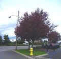
The Hashpoint is under yon tree.
