Difference between revisions of "2011-05-04 28 -81"
imported>Rhonda (finally a hash in lakeland!) |
imported>FippeBot m (Location) |
||
| (One intermediate revision by one other user not shown) | |||
| Line 1: | Line 1: | ||
| − | |||
| − | |||
| − | |||
| − | |||
| − | |||
| − | |||
| − | |||
| − | |||
| − | |||
| − | |||
{{meetup graticule | {{meetup graticule | ||
| lat=28 | | lat=28 | ||
| Line 19: | Line 9: | ||
== Location == | == Location == | ||
<!-- where you've surveyed the hash to be --> | <!-- where you've surveyed the hash to be --> | ||
| + | Under a tree. | ||
== Participants == | == Participants == | ||
<!-- who attended --> | <!-- who attended --> | ||
| + | * [[User:Rhonda|Rhonda]] | ||
== Plans == | == Plans == | ||
<!-- what were the original plans --> | <!-- what were the original plans --> | ||
| + | Program the GPS. Go. | ||
== Expedition == | == Expedition == | ||
<!-- how it all turned out. your narrative goes here. --> | <!-- how it all turned out. your narrative goes here. --> | ||
| + | This was definitely one of the easiest and probably the shortest geohash I've ever done. | ||
| + | |||
| + | The hashpoint was under 15km straight-line distance from where I'm staying in Florida. Due to a combination of lakes (in Lakeland? Really?) and private property, most roads don't go straight through for very far, so I had to drive away from the hash for a while, tangent to the hash for a while, then finally get on a road heading towards it. The hashpoint happened to be one block to the side of a major thoroughfare which changed names several times but remained the same road from the hashpoint area down to where it crossed the street where I'm staying. It also happened to be a road I'd used before, so I didn't bother with a map, just remembered that the point was to the right and I should take the right turn immediately after my GPS needle swung to show I was abeam the point. | ||
| + | |||
| + | The hashtree was beside a church. I parked in the church driveway, walked over to the tree, barely had to GPS-dance at all, took a couple of pictures, and left. | ||
| − | + | Even though the hash itself wasn't very exciting, it was exciting to finally get one after being here for two months! If it hadn't already been at the end of a long work day and after dinner and after 7PM, I would have cycled there on my cheap FL bike. Next time, bike. | |
| − | |||
== Photos == | == Photos == | ||
| Line 36: | Line 33: | ||
Image:2010-##-## ## ## Alpha.jpg | Witty Comment | Image:2010-##-## ## ## Alpha.jpg | Witty Comment | ||
--> | --> | ||
| − | <gallery | + | <gallery> |
| + | Image:2011-05-04 28 -81 church.JPG | The hash was in a church yard | ||
| + | Image:2011-05-04 28 -81 gps.JPG | right about here | ||
| + | Image:2011-05-04 28 -81 hashtree.JPG | under this tree. | ||
</gallery> | </gallery> | ||
| Line 42: | Line 42: | ||
{{#vardefine:ribbonwidth|800px}} | {{#vardefine:ribbonwidth|800px}} | ||
<!-- Add any achievement ribbons you earned below, or remove this section --> | <!-- Add any achievement ribbons you earned below, or remove this section --> | ||
| + | {{holy hash | ||
| + | | latitude = 28 | ||
| + | | longitude = -81 | ||
| + | | date = 2011-05-04 | ||
| + | | name = Rhonda | ||
| + | | description = in the yard of the New Hope M.B. Church | ||
| + | | image = 2011-05-04 28 -81 church.JPG | ||
| + | }} | ||
| − | |||
| − | |||
| − | |||
| − | |||
| − | |||
| − | |||
| − | |||
| − | |||
| − | |||
| − | |||
[[Category:Expeditions]] | [[Category:Expeditions]] | ||
| − | |||
[[Category:Expeditions with photos]] | [[Category:Expeditions with photos]] | ||
| − | |||
| − | |||
| − | |||
| − | |||
[[Category:Coordinates reached]] | [[Category:Coordinates reached]] | ||
| − | + | {{location|US|FL|PO}} | |
| − | |||
| − | |||
| − | |||
| − | |||
| − | |||
| − | |||
| − | |||
| − | |||
| − | |||
Latest revision as of 06:22, 9 August 2019
| Wed 4 May 2011 in 28,-81: 28.0649321, -81.9760917 geohashing.info google osm bing/os kml crox |
Location
Under a tree.
Participants
Plans
Program the GPS. Go.
Expedition
This was definitely one of the easiest and probably the shortest geohash I've ever done.
The hashpoint was under 15km straight-line distance from where I'm staying in Florida. Due to a combination of lakes (in Lakeland? Really?) and private property, most roads don't go straight through for very far, so I had to drive away from the hash for a while, tangent to the hash for a while, then finally get on a road heading towards it. The hashpoint happened to be one block to the side of a major thoroughfare which changed names several times but remained the same road from the hashpoint area down to where it crossed the street where I'm staying. It also happened to be a road I'd used before, so I didn't bother with a map, just remembered that the point was to the right and I should take the right turn immediately after my GPS needle swung to show I was abeam the point.
The hashtree was beside a church. I parked in the church driveway, walked over to the tree, barely had to GPS-dance at all, took a couple of pictures, and left.
Even though the hash itself wasn't very exciting, it was exciting to finally get one after being here for two months! If it hadn't already been at the end of a long work day and after dinner and after 7PM, I would have cycled there on my cheap FL bike. Next time, bike.
Photos
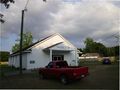
The hash was in a church yard
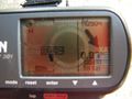
right about here

under this tree.


Achievements
Rhonda earned the Holy hash achievement
|