Difference between revisions of "2011-05-07 47 8"
imported>TheOneRing |
imported>FippeBot m (Location) |
||
| (4 intermediate revisions by one other user not shown) | |||
| Line 6: | Line 6: | ||
== Location == | == Location == | ||
| − | The geohash is between | + | The geohash is between Effretikon (canton Zürich) and Kempttal (ZH), near Zürich. It is located on a meadow, but unfortunately next to an autobahn (A4). |
== Who Went == | == Who Went == | ||
| − | [[User:TheOneRing|TheOneRing]] - by public transport | + | [[User:TheOneRing|TheOneRing]] - by public transport. |
| − | == | + | == The Expedition == |
=== TheOneRing === | === TheOneRing === | ||
| − | + | What a nice, sunny day, really perfect to go geohashing. The geohash of [[2010-12-12 47 8|one day last December]] was located in Bassersdorf, which lies on the way to Effretikon. So I knew how to get there with public transport.<br> | |
| + | I left Berne at half past one to be at the geohash at four o'clock. In Zürich I had to change trains to go to Effretikon. I recognized too late that I packed the wrong map so I had only my GPS. No problem? Well, I was in a valley, so it took a while to get suitable connection. During the search, I was not sure whether or not I went in the correct direction. I did, in the end. On my way I went underneath some high voltage power lines where you could hear the crackling of the electricity. It was quite an odd noise.<br> | ||
| + | It was still very warm and sunny, perfect conditions to have a picnic with cake. I was a little bit early so I waited till 4 o'clock and beyond, but noone showed up. At one point you could notice that the geohash is in the entry lane of the airport Zürich-Kloten, because a plane was starting. Anyway the countyside was quite nice, but you could hear the autobahn all the time, which destroyed the nice picture a little bit. After having a quick meal and taking the usual photos I walked back to Effretikon and took the trains back to Berne. | ||
| + | |||
| + | == Photos == | ||
| + | === TheOneRing === | ||
| + | <gallery perrow="5"> | ||
| + | Image:20110507Geohash.jpg|The tripod marks the geohash | ||
| + | Image:20110507GPS.jpg|Proof that I reached the right coordinates... | ||
| + | Image:20110507Ticket.jpg|...on the right date | ||
| + | Image:20110507Me.jpg|StupidGrin | ||
| + | Image:20110507Surrounding1.jpg|View to the countryside | ||
| + | Image:20110507Surrounding2.jpg|Again, but with the autobahn in the background (invisible, but hearable) | ||
| + | Image:20110507Surrounding3.jpg|Again, with the high voltage power lines | ||
| + | Image:20110507Bach.jpg|A rivulet near the geohash | ||
| + | Image:20110507Flugzeug.jpg|A starting plane | ||
| + | Image:20110507Zug.jpg|The train station of Effretikon and the kind of train I took | ||
| + | </gallery> | ||
| + | |||
| + | == Achievements == | ||
| + | {{land geohash | latitude = 47 | longitude = 8 | date = 2011-05-07 | name = TheOneRing }} | ||
| + | {{Public transport geohash | latitude = 47 | longitude = 8 | date = 2011-05-07 | name = TheOneRing}} | ||
| + | {{xkcd centurion | count = 2 | name = TheOneRing}} | ||
| + | |||
| + | [[Category:Expeditions]] | ||
| + | [[Category:Expeditions with photos]] | ||
| + | [[Category:Coordinates reached]] | ||
| + | {{location|CH|ZH}} | ||
Latest revision as of 06:25, 9 August 2019
| Sat 7 May 2011 in 47,8: 47.4425543, 8.6903141 geohashing.info google osm bing/os kml crox |
Contents
Location
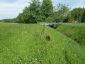
The geohash is between Effretikon (canton Zürich) and Kempttal (ZH), near Zürich. It is located on a meadow, but unfortunately next to an autobahn (A4).
Who Went
TheOneRing - by public transport.
The Expedition
TheOneRing
What a nice, sunny day, really perfect to go geohashing. The geohash of one day last December was located in Bassersdorf, which lies on the way to Effretikon. So I knew how to get there with public transport.
I left Berne at half past one to be at the geohash at four o'clock. In Zürich I had to change trains to go to Effretikon. I recognized too late that I packed the wrong map so I had only my GPS. No problem? Well, I was in a valley, so it took a while to get suitable connection. During the search, I was not sure whether or not I went in the correct direction. I did, in the end. On my way I went underneath some high voltage power lines where you could hear the crackling of the electricity. It was quite an odd noise.
It was still very warm and sunny, perfect conditions to have a picnic with cake. I was a little bit early so I waited till 4 o'clock and beyond, but noone showed up. At one point you could notice that the geohash is in the entry lane of the airport Zürich-Kloten, because a plane was starting. Anyway the countyside was quite nice, but you could hear the autobahn all the time, which destroyed the nice picture a little bit. After having a quick meal and taking the usual photos I walked back to Effretikon and took the trains back to Berne.
Photos
TheOneRing
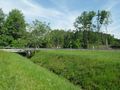
The tripod marks the geohash
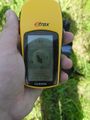
Proof that I reached the right coordinates...
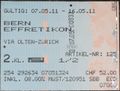
...on the right date

StupidGrin
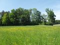
View to the countryside
Again, but with the autobahn in the background (invisible, but hearable)
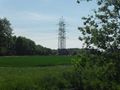
Again, with the high voltage power lines
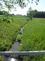
A rivulet near the geohash
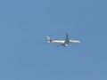
A starting plane
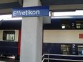
The train station of Effretikon and the kind of train I took


Achievements
TheOneRing earned the Land geohash achievement
|
TheOneRing earned the Public transport geohash achievement
|
TheOneRing earned the xkcd Nullaturion achievement
|