Difference between revisions of "2011-05-22 52 1"
imported>Sourcerer |
imported>Sourcerer |
||
| Line 1: | Line 1: | ||
| − | |||
| − | |||
| − | |||
| − | |||
{{meetup graticule | {{meetup graticule | ||
| lat=52 | | lat=52 | ||
| Line 8: | Line 4: | ||
| date=2011-05-22 | | date=2011-05-22 | ||
| graticule_name=Norwich | | graticule_name=Norwich | ||
| − | | graticule_link=Norwich, United Kingdom}} | + | | graticule_link=Norwich, United Kingdom |
| + | }} | ||
| + | |||
| + | == Location == | ||
| + | |||
| + | Right on the north bank of the Norfolk Broads river Bure, west of the road bridge and north east of Acle, Norfolk, UK. | ||
== Participants == | == Participants == | ||
| Line 16: | Line 17: | ||
== The Expedition == | == The Expedition == | ||
| − | This was an easy hashpoint to reach. It was near the road and there was a good path giving access to the riverside boat moorings. A boat was moored right inside the circle of uncertainty with an | + | This was an easy hashpoint to reach. It was near the road and there was a good path giving access to the riverside boat moorings. A boat was moored right inside the circle of uncertainty with an elderly couple relaxing on board. I did not trouble them with an explanation of why I was taking photos. In any case it was an attractive tourist spot. It was sunset on a beautiful summer evening. The only down side was another brush fire because of the drought weather. Many fire engines were heading home after the incident. The farmers are really worried. Their crops are in trouble. |
== Photo Gallery == | == Photo Gallery == | ||
| − | <gallery | + | <gallery> |
Image:2011-05-22_52_1_Sourcerer_01.jpg.jpg|Garmin Mapsource Track | Image:2011-05-22_52_1_Sourcerer_01.jpg.jpg|Garmin Mapsource Track | ||
Image:2011-05-22_52_1_Sourcerer_02.jpg.jpg|The boat at the hash | Image:2011-05-22_52_1_Sourcerer_02.jpg.jpg|The boat at the hash | ||
| Line 44: | Line 45: | ||
}} | }} | ||
| + | [[Category:Expeditions]] | ||
[[Category:Expeditions with photos]] | [[Category:Expeditions with photos]] | ||
[[Category:Coordinates reached]] | [[Category:Coordinates reached]] | ||
| − | |||
| − | |||
Revision as of 15:28, 22 August 2012
| Sun 22 May 2011 in Norwich: 52.6495345, 1.5661950 geohashing.info google osm bing/os kml crox |
Contents
Location
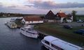
Right on the north bank of the Norfolk Broads river Bure, west of the road bridge and north east of Acle, Norfolk, UK.
Participants
The Expedition
This was an easy hashpoint to reach. It was near the road and there was a good path giving access to the riverside boat moorings. A boat was moored right inside the circle of uncertainty with an elderly couple relaxing on board. I did not trouble them with an explanation of why I was taking photos. In any case it was an attractive tourist spot. It was sunset on a beautiful summer evening. The only down side was another brush fire because of the drought weather. Many fire engines were heading home after the incident. The farmers are really worried. Their crops are in trouble.
Photo Gallery
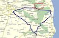
Garmin Mapsource Track

The boat at the hash
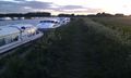
The boat at the hash
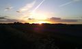
Sun set
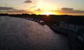
The river Bure
The river Bure
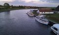
The river Bure


Other Geohashing Expeditions and Plans on This Day
Expeditions and Plans
| 2011-05-22 | ||
|---|---|---|
| The Dalles, Oregon | kydlt | Tucker County Park, South of the town of Hood River. |
| Portland, Oregon | Jim, Michael | The center median area on I-205 just south of the SR500 on the Washington s... |
| Norwich, United Kingdom | Sourcerer | Right on the north bank of the Norfolk Broads river Bure, west of the road ... |
| Brandenburg, Germany | Ekorren | A field in the Kotzen municipality. Inaccessible unless you would le... |
| Malmö, Sweden | Llavids | Vomb, Skåne, Sweden. |
Achievements
Sourcerer earned the Consecutive geohash achievement
|