2011-06-07 52 1
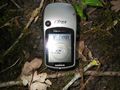
| Tue 7 Jun 2011 in Norwich: 52.4132768, 1.5299640 geohashing.info google osm bing/os kml crox |
Contents
Location
In estate parkland at Gorse Thick, 500 metres south of Redisham Hall near Ringsfield Corner, Suffolk, UK.
Participants
Expedition
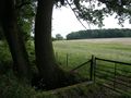
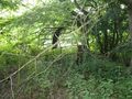
On a bright breezy evening on the way home from work, Neil drove to Becks Green and parked on the roadside. There was a 1.8 km walk from the road to the hashpoint along a public footpath skirting wheat fields and later entering some woodland. The parallel stream was completely dry after three months of drought. The hashpoint was 70 metres east of the public path. The deserted site surrounded by woodland held derelict farm buildings which must have housed livestock. There were no "no entry" signs so it was easy to reach the exact point in the wood a few metres from one of the buildings.
Photos
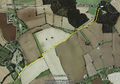
Google Earth Track
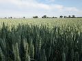
Ripening Wheat
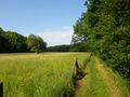
Estate Park Land
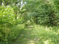
The Woodland
More Estate Park Land
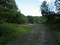
Derelict Buildings
At the Hashpoint
Derelict Animal Feeder
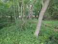
Woodland at the Hashpoint


Expeditions and Plans
| 2011-06-07 | ||
|---|---|---|
| Duluth, Minnesota | Le Fou | Near Saginaw, MN, across from a truck weigh station and not far west of the... |
| Norwich, United Kingdom | Sourcerer | In estate parkland at Gorse Thick, 500 metres south of Redisham Hall near R... |
| Sheffield, United Kingdom | Monty | Loxley Common, Sheffield |
Sourcerer's Expedition Links
2011-05-30 53 -0 - 2011-06-07 52 1 - 2011-06-18 51 -1 - KML file download of Sourcerer's expeditions for use with Google Earth.