Difference between revisions of "2011-06-21 -27 152"
imported>Darryl (→Photos) |
m (per Renaming Proposal) |
||
| (14 intermediate revisions by 5 users not shown) | |||
| Line 1: | Line 1: | ||
| − | |||
| − | |||
| − | |||
| − | |||
| − | |||
| − | |||
| − | |||
| − | |||
| − | |||
{{meetup graticule | {{meetup graticule | ||
| lat=-27 | | lat=-27 | ||
| Line 14: | Line 5: | ||
}} | }} | ||
| − | |||
__NOTOC__ | __NOTOC__ | ||
== Location == | == Location == | ||
| − | + | South of Esk with 6 previous locations (the past week) also reached on the day - on Google Maps[http://goo.gl/maps/PZES]<br> | |
| − | + | 21.06.2011 South of Esk<br> | |
| − | + | 20.06.2011 South of Esk<br> | |
| + | 19.06.2011 Southwest of Esk<br> | ||
| + | 18.06.2011 East of Wivenhoe Dam<br> | ||
| + | 17.06.2011 Southeast of Marburg<br> | ||
16.06.2011 Northeast of Harrisville<br> | 16.06.2011 Northeast of Harrisville<br> | ||
| − | + | 15.06.2011 Northwest of Tarome | |
| − | |||
| − | |||
| − | |||
| − | |||
== Participants == | == Participants == | ||
| − | + | * [[User:Darryl|Darryl]] | |
| − | Darryl | ||
== Plans == | == Plans == | ||
| − | |||
| − | |||
As June 21 was my birthday (and wanting to do something a bit different with my day), I decided I'd have a look at doing the geohash for the day. I had a short planning session the evening before and determined that it was probably feasible to do the past weeks geohash's in one day. Or at least a drive by. (I like driving and with an MX-5 at my disposal, what could be better than doing my first geohash!) | As June 21 was my birthday (and wanting to do something a bit different with my day), I decided I'd have a look at doing the geohash for the day. I had a short planning session the evening before and determined that it was probably feasible to do the past weeks geohash's in one day. Or at least a drive by. (I like driving and with an MX-5 at my disposal, what could be better than doing my first geohash!) | ||
| Line 39: | Line 25: | ||
== Expedition == | == Expedition == | ||
| − | |||
Away much later start than I had anticipated but fuelled up, and coffee in hand, I was out of the servo at Kenmore just after 10:30am. I had decided to make some headway early, so took the Ipswich Motorway rather than follow the GPS directions via Mt Crosby Road. | Away much later start than I had anticipated but fuelled up, and coffee in hand, I was out of the servo at Kenmore just after 10:30am. I had decided to make some headway early, so took the Ipswich Motorway rather than follow the GPS directions via Mt Crosby Road. | ||
| Line 53: | Line 38: | ||
A very short drive then back to the main road and down another dirt road to todays hash. And another gate. What had appeared to be a road on the maps turned out to be a fire break. Less than 400m to the spot though, so an easy walk to get there. | A very short drive then back to the main road and down another dirt road to todays hash. And another gate. What had appeared to be a road on the maps turned out to be a fire break. Less than 400m to the spot though, so an easy walk to get there. | ||
| − | Several hundred kilometres, drive by's to 6 locations, and 1 | + | Several hundred kilometres, drive by's to 6 locations, and 1 geohash achieved. A good days driving! |
| − | |||
| − | |||
| − | |||
== Photos == | == Photos == | ||
| − | |||
| − | |||
| − | |||
<gallery perrow="5"> | <gallery perrow="5"> | ||
Image:20110621_114218_-27_152.png.jpg | (1) Had a signal but still no image after 5 minutes. | Image:20110621_114218_-27_152.png.jpg | (1) Had a signal but still no image after 5 minutes. | ||
| Line 83: | Line 62: | ||
Image:20110621_150422_-27_152.png.jpg | Now I know what everyone means by the GPS dance! | Image:20110621_150422_-27_152.png.jpg | Now I know what everyone means by the GPS dance! | ||
Image:20110621_152001_-27_152.JPG | Yep, that’s a fire break! | Image:20110621_152001_-27_152.JPG | Yep, that’s a fire break! | ||
| − | Image:20110621_152101_-27_152.JPG | And it looks like one that way too! | + | Image:20110621_152101_-27_152.JPG | And it looks like one that way too! Now, which way did I come? |
</gallery> | </gallery> | ||
== Achievements == | == Achievements == | ||
{{#vardefine:ribbonwidth|800px}} | {{#vardefine:ribbonwidth|800px}} | ||
| − | + | {{Birthday geohash | |
| − | + | | latitude = -27 | |
| − | + | | longitude = 152 | |
| − | + | | date = 2011-06-21 | |
| − | + | | pronoun = his | |
| − | + | | name = [[User:Darryl|Darryl]] | |
| − | + | }} | |
| − | + | {{Graticule unlocked | |
| − | [[ | + | | latitude = -27 |
| − | + | | longitude = 152 | |
| − | + | | date = 2011-06-21 | |
| − | + | | name = [[User:Darryl|Darryl]] | |
| − | + | }} | |
| − | [[ | ||
| − | |||
| − | |||
| − | |||
[[Category:Expeditions]] | [[Category:Expeditions]] | ||
| − | |||
[[Category:Expeditions with photos]] | [[Category:Expeditions with photos]] | ||
| − | |||
| − | |||
| − | |||
| − | |||
| − | |||
[[Category:Coordinates reached]] | [[Category:Coordinates reached]] | ||
| − | + | {{location|AU|QLD|SO}} | |
| − | |||
| − | |||
| − | |||
| − | |||
| − | |||
| − | |||
| − | |||
| − | |||
| − | |||
Latest revision as of 05:53, 20 March 2024
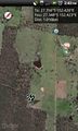
| Tue 21 Jun 2011 in -27,152: -27.3528047, 152.3978951 geohashing.info google osm bing/os kml crox |
Location
South of Esk with 6 previous locations (the past week) also reached on the day - on Google Maps[1]
21.06.2011 South of Esk
20.06.2011 South of Esk
19.06.2011 Southwest of Esk
18.06.2011 East of Wivenhoe Dam
17.06.2011 Southeast of Marburg
16.06.2011 Northeast of Harrisville
15.06.2011 Northwest of Tarome
Participants
Plans
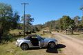
As June 21 was my birthday (and wanting to do something a bit different with my day), I decided I'd have a look at doing the geohash for the day. I had a short planning session the evening before and determined that it was probably feasible to do the past weeks geohash's in one day. Or at least a drive by. (I like driving and with an MX-5 at my disposal, what could be better than doing my first geohash!)
Tuesday morning, and, surprisingly, the location for the 21st was very close to the one for the 20th. It looked like the full weeks worth was on the cards and - bonus - in sequential order! The location for the 21st also appeared to be on a road and accessible, making it the only location that wasn't firmly on private property or a (insert time frame here) walk away from the nearest road.
Expedition
Away much later start than I had anticipated but fuelled up, and coffee in hand, I was out of the servo at Kenmore just after 10:30am. I had decided to make some headway early, so took the Ipswich Motorway rather than follow the GPS directions via Mt Crosby Road.
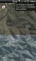
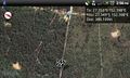
It took just over an hour to make the first location (for Wednesday 15.06.11) near Tarome. Mobile access was obviously very limited as Geohash Droid wouldn't produce a satellite image even after 5 minutes of patiently waiting. Decided that the location data would have to do, along with a couple of photo's in the general direction of the geohash.
I had seen a few roadwork sites enroute to location 1 and went through another 6 or 7 enroute to locations 2 and 3. End of financial year spending anyone?
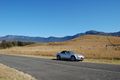
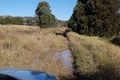
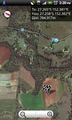
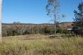
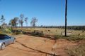
The nearest point to location 2 was easy to find being in a new subdivision. Location 3 proved a bit more challenging - the MX-5’s lack of 4WD and adequate ground clearance brought that one to an early stop. Location 4 was well into the hill country so settled for a grid some 2km from the location. An easy drive followed to a roadside stop overlooking location 5. A short drive down the road, and a couple of kilometres further than the GPS would have me believe, to - a gate. Easy to see where location 6 was by comparing reality to the satellite image though. A very short drive then back to the main road and down another dirt road to todays hash. And another gate. What had appeared to be a road on the maps turned out to be a fire break. Less than 400m to the spot though, so an easy walk to get there.
Several hundred kilometres, drive by's to 6 locations, and 1 geohash achieved. A good days driving!
Photos
(1) Had a signal but still no image after 5 minutes.
(1) Just a kilometre or so along the fence will do.
(1) Location 1 from 1km back along the road. In the trees on the low ridge above the mirror.
(2) Easy to get this far!
(2) It’s just the other side of the shed down there.
(3) That’s as close as I’ll be for this one.
(3) Somewhere past the house and over the rise.
(3) Well, I made it this far but...
(3) Hmm, not with these tyres...
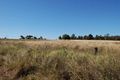
(4) 2km to go.
(4) No chance of seeing it from here.
(5) A few km from Esk.
(5) And kept one eye and ear to the right in case the prominently notified guard dog decided we needed a chat.
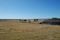
(6) A lot closer than I’d expected on this one.
(6) Past the dam to the line of trees right of centre.
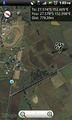
(7) 400m to go. Didn’t quite get to drive there...
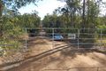
Due to this gate, but...
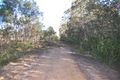
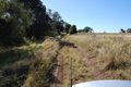
400m down the fire break - easy!

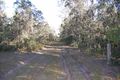
Now I know what everyone means by the GPS dance!
Yep, that’s a fire break!
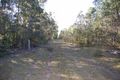
And it looks like one that way too! Now, which way did I come?


Achievements
Darryl earned the Birthday Geohash Achievement
|
Darryl earned the Graticule Unlocked Achievement
|