Difference between revisions of "2011-07-04 -39 175"
From Geohashing
imported>Greenslime m (Created page with "{{subst:Expedition |lat = -39 |lon = 175 |date = 2011-07-04 }}") |
(per Renaming Proposal) |
||
| (3 intermediate revisions by 2 users not shown) | |||
| Line 1: | Line 1: | ||
| − | |||
| − | |||
| − | |||
| − | |||
| − | |||
| − | |||
| − | |||
| − | |||
| − | |||
| − | |||
{{meetup graticule | {{meetup graticule | ||
| lat=-39 | | lat=-39 | ||
| Line 15: | Line 5: | ||
}} | }} | ||
| − | |||
__NOTOC__ | __NOTOC__ | ||
== Location == | == Location == | ||
| − | + | About 25 m from roadside off SH49, close to Waiouru Military Camp | |
== Participants == | == Participants == | ||
| − | + | [[User:Greenslime|Greenslime]] | |
== Plans == | == Plans == | ||
| − | + | On my way back from Palmerston North to Auckland, this beautiful cherry was on the way. | |
== Expedition == | == Expedition == | ||
| − | + | Very non eventful, at least the hash gave me an excuse to have a break from the 6.5 hour drive from Palmy to Auckland. Was quite lucky with this location as a lot of the land in this area is Army Training Area thus restricted access. So I parked up on the side of the road, jumped the fence, scared the sheep. Followed the red dot on my phone and snapped a couple of pictures. Mt Ruapehu, the North Islands only skiing mountain has a heavy coating of snow, it being the middle of winter over here. | |
| − | |||
| − | |||
== Photos == | == Photos == | ||
| − | |||
| − | |||
| − | |||
<gallery perrow="5"> | <gallery perrow="5"> | ||
| + | File:2011-07-04 -39 175 Welcome to Waiouru.jpg|Welcome to Waiouru, the desert oasis. | ||
| + | File:2011-07-04 -39 175 View from the Hash.jpg|Sheep, as per normal | ||
| + | File:2011-07-04 -39 175 Mt Ruapehu.jpg|Mt Ruapehu | ||
</gallery> | </gallery> | ||
== Achievements == | == Achievements == | ||
{{#vardefine:ribbonwidth|800px}} | {{#vardefine:ribbonwidth|800px}} | ||
| − | + | {{Graticule unlocked | |
| + | | latitude = -39 | ||
| + | | longitude = 175 | ||
| + | | date = 2011-07-04 | ||
| + | | name = [[User:Greenslime|Greenslime]] | ||
| + | | image = 2011-07-04 -39 175 Mt Ruapehu.jpg | ||
| + | }} | ||
| − | + | [[Category:Graticule unlocked achievement]] | |
| − | |||
| − | |||
| − | [[Category: | ||
| − | |||
| − | |||
| − | |||
| − | |||
| − | |||
| − | |||
| − | |||
[[Category:Expeditions]] | [[Category:Expeditions]] | ||
| − | + | [[Category:Expeditions with photos]] | |
| − | [[Category:Expeditions with photos]] | ||
| − | |||
| − | |||
| − | |||
| − | |||
| − | |||
[[Category:Coordinates reached]] | [[Category:Coordinates reached]] | ||
| − | + | {{location|NZ|MWT}} | |
| − | |||
| − | |||
| − | |||
| − | |||
| − | |||
| − | |||
| − | |||
| − | |||
| − | |||
Latest revision as of 03:03, 20 March 2024
| Mon 4 Jul 2011 in -39,175: -39.4696023, 175.6514400 geohashing.info google osm bing/os kml crox |
Location
About 25 m from roadside off SH49, close to Waiouru Military Camp
Participants
Plans
On my way back from Palmerston North to Auckland, this beautiful cherry was on the way.
Expedition
Very non eventful, at least the hash gave me an excuse to have a break from the 6.5 hour drive from Palmy to Auckland. Was quite lucky with this location as a lot of the land in this area is Army Training Area thus restricted access. So I parked up on the side of the road, jumped the fence, scared the sheep. Followed the red dot on my phone and snapped a couple of pictures. Mt Ruapehu, the North Islands only skiing mountain has a heavy coating of snow, it being the middle of winter over here.
Photos
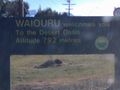
Welcome to Waiouru, the desert oasis.
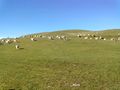
Sheep, as per normal
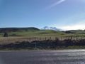
Mt Ruapehu


Achievements
Greenslime earned the Graticule Unlocked Achievement
|