Difference between revisions of "2011-07-14 49 8"
imported>Ilpadre (→Tracklog: +tracklog) |
imported>Ilpadre m (→Expedition: last man standing) |
||
| Line 20: | Line 20: | ||
Pretty much my standard walk expedition (total distance walked: 13.9 km). The coordinates were right at the edge of a field and accessible, since the neighboring field had been cut recently, like many other grain fields in that area. The actual coordinates would have been one or two steps into a corn field, but I was close enough to call it a success without having to risk damaging any crops. | Pretty much my standard walk expedition (total distance walked: 13.9 km). The coordinates were right at the edge of a field and accessible, since the neighboring field had been cut recently, like many other grain fields in that area. The actual coordinates would have been one or two steps into a corn field, but I was close enough to call it a success without having to risk damaging any crops. | ||
| + | |||
| + | {{Last man standing | latitude = 49 | longitude = 8 | date = 2011-07-04 | name = [[User:ilpadre|ilpadre]]}} | ||
== Tracklog == | == Tracklog == | ||
Revision as of 08:00, 9 April 2012
| Thu 14 Jul 2011 in 49,8: 49.3859788, 8.6030285 geohashing.info google osm bing/os kml crox |
Location
In a corn field in Plankstadt.
Plans
Walk there.
Participants
Expedition
Pretty much my standard walk expedition (total distance walked: 13.9 km). The coordinates were right at the edge of a field and accessible, since the neighboring field had been cut recently, like many other grain fields in that area. The actual coordinates would have been one or two steps into a corn field, but I was close enough to call it a success without having to risk damaging any crops.
ilpadre earned the Last man standing achievement
|
Tracklog
http://www.everytrail.com/view_trip.php?trip_id=1194391
Photos
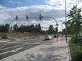
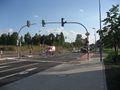
Revisiting a street, now finished after one year of construction work.
Another revisit.
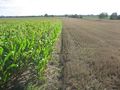
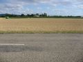
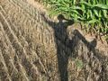
Two fields, one hashpoint.
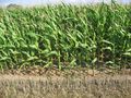
There it is. Close enough.
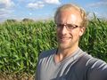
Obligatory.
Been there, done that.
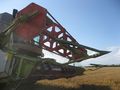
Many of the grain fields were freshly harvested.
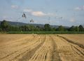
Birds took care of the rest.


