Difference between revisions of "2011-07-21 55 85"
imported>LemonadeCellar |
m (per Renaming Proposal) |
||
| (4 intermediate revisions by 3 users not shown) | |||
| Line 1: | Line 1: | ||
| − | |||
| − | |||
| − | |||
| − | |||
| − | |||
| − | |||
| − | |||
[[Image:{{{image|2011_07_21_55_85_field.jpg}}}|thumb|left]] | [[Image:{{{image|2011_07_21_55_85_field.jpg}}}|thumb|left]] | ||
| Line 15: | Line 8: | ||
}} | }} | ||
| − | |||
__NOTOC__ | __NOTOC__ | ||
== Location == | == Location == | ||
| Line 21: | Line 13: | ||
== Participants == | == Participants == | ||
| − | Just me, [[LemonadeCellar]]. | + | Just me, [[User:LemonadeCellar|LemonadeCellar]]. |
== Plans == | == Plans == | ||
| Line 28: | Line 20: | ||
== Expedition == | == Expedition == | ||
The first part (getting there) went well. After a 50-minute long bus ride I got off the bus and saw Topki for the first time. And, well, it's a typical Russian town with Khrushchev buildings and unpresentable-looking private houses. Walking for an hour (5km) is boring (damn it, should've taken my earpieces) and uneventful. Wandered around the circle-shaped crossing for five minutes because GPS stopped working. Walking on the field was easy (good thing it didn't rain yesterday, otherwise this would've been a disaster). Obviously, there was no one at the hashpoint, not even a single farmer (and I even made up a story about making an article describing the life of an ordinary farmer for my college project), so I just placed my note and left. The second part (getting home) didn't go quite according to the plan, as I had to spend an hour doing nothing because I didn't bother looking at the bus schedule and my phone's battery couldn't handle the pressure. Overall, pretty decent for my first expedition. | The first part (getting there) went well. After a 50-minute long bus ride I got off the bus and saw Topki for the first time. And, well, it's a typical Russian town with Khrushchev buildings and unpresentable-looking private houses. Walking for an hour (5km) is boring (damn it, should've taken my earpieces) and uneventful. Wandered around the circle-shaped crossing for five minutes because GPS stopped working. Walking on the field was easy (good thing it didn't rain yesterday, otherwise this would've been a disaster). Obviously, there was no one at the hashpoint, not even a single farmer (and I even made up a story about making an article describing the life of an ordinary farmer for my college project), so I just placed my note and left. The second part (getting home) didn't go quite according to the plan, as I had to spend an hour doing nothing because I didn't bother looking at the bus schedule and my phone's battery couldn't handle the pressure. Overall, pretty decent for my first expedition. | ||
| + | |||
| + | == Tracklog == | ||
| + | [[Image:2011_07_21_55_85_tracklog.jpg]] | ||
== Photos == | == Photos == | ||
| − | |||
| − | |||
| − | |||
<gallery perrow="5"> | <gallery perrow="5"> | ||
Image:2011_07_21_55_85_sign.jpg | That's... an interesting riddle. | Image:2011_07_21_55_85_sign.jpg | That's... an interesting riddle. | ||
| Line 43: | Line 35: | ||
== Achievements == | == Achievements == | ||
{{#vardefine:ribbonwidth|800px}} | {{#vardefine:ribbonwidth|800px}} | ||
| − | {{ | + | {{Graticule unlocked | latitude = 55 | longitude = 85 | date = 2011-07-21 | name = LemonadeCellar }} |
{{land geohash | latitude = 55 | longitude = 85 | date = 2011-07-21 | name = LemonadeCellar | image = 2011_07_21_55_85_field.jpg }} | {{land geohash | latitude = 55 | longitude = 85 | date = 2011-07-21 | name = LemonadeCellar | image = 2011_07_21_55_85_field.jpg }} | ||
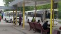
{{Public transport geohash | latitude = 55 | longitude = 85 | date = 2011-07-21 | busline = 102 Kemerovo-Topki | name = LemonadeCellar | image = 2011_07_21_55_85_buses.jpg }} | {{Public transport geohash | latitude = 55 | longitude = 85 | date = 2011-07-21 | busline = 102 Kemerovo-Topki | name = LemonadeCellar | image = 2011_07_21_55_85_buses.jpg }} | ||
| Line 52: | Line 44: | ||
[[Category:Expeditions with photos]] | [[Category:Expeditions with photos]] | ||
[[Category:Coordinates reached]] | [[Category:Coordinates reached]] | ||
| + | {{location|RU|KEM}} | ||
Latest revision as of 05:51, 20 March 2024

| Thu 21 Jul 2011 in 55,85: 55.2915015, 85.6913244 geohashing.info google osm bing/os kml crox |
Location
On a empty field near a quiet little town called Topki.
Participants
Just me, LemonadeCellar.
Plans
Get to Topki by bus, walk the remaining distance, return in the same manner, be home for dinner.
Expedition
The first part (getting there) went well. After a 50-minute long bus ride I got off the bus and saw Topki for the first time. And, well, it's a typical Russian town with Khrushchev buildings and unpresentable-looking private houses. Walking for an hour (5km) is boring (damn it, should've taken my earpieces) and uneventful. Wandered around the circle-shaped crossing for five minutes because GPS stopped working. Walking on the field was easy (good thing it didn't rain yesterday, otherwise this would've been a disaster). Obviously, there was no one at the hashpoint, not even a single farmer (and I even made up a story about making an article describing the life of an ordinary farmer for my college project), so I just placed my note and left. The second part (getting home) didn't go quite according to the plan, as I had to spend an hour doing nothing because I didn't bother looking at the bus schedule and my phone's battery couldn't handle the pressure. Overall, pretty decent for my first expedition.
Tracklog

Photos
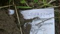
That's... an interesting riddle.
The Internets were here.
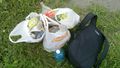
500m of the road, three bags. Wonderful.

Rough translation: "The soul rejoices in clean places." Indeed.
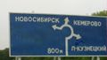
The right one is going to take me home.


Achievements
LemonadeCellar earned the Graticule Unlocked Achievement
|
LemonadeCellar earned the Land geohash achievement
|
LemonadeCellar earned the Public transport geohash achievement
|
LemonadeCellar earned the GeoTrash Geohash Achievement
|