Difference between revisions of "2011-07-24 47 7"
imported>Hijackal (doesn't need much planning for me...) |
imported>FippeBot m (Location) |
||
| (3 intermediate revisions by one other user not shown) | |||
| Line 26: | Line 26: | ||
== Expedition == | == Expedition == | ||
| − | + | Soon. | |
| − | |||
| − | |||
| − | |||
== Photos == | == Photos == | ||
| Line 36: | Line 33: | ||
--> | --> | ||
<gallery perrow="5"> | <gallery perrow="5"> | ||
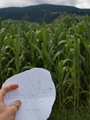
| + | File:2011-07-24 47 7 1 Plan.png | The plan is made. | ||
| + | File:2011-07-24 47 7 2 go.PNG | Off I go... | ||
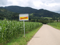
| + | File:2011-07-24 47 7 3 haeusleberg.PNG | Luckily, don't have to go up the Häuseleberg today... | ||
| + | File:2011-07-24 47 7 4 hills.PNG | The hills of Hobbitried. Will I return to see them again? | ||
| + | File:2011-07-24 47 7 5 bread.PNG | A first break, with fresh bread | ||
| + | File:2011-07-24 47 7 6 guardian.PNG | A foreboding wooden guardian. Why is its face frozen in agony? | ||
| + | File:2011-07-24 47 7 7 next stop.PNG | The next opportunity for a nice meal comes into view | ||
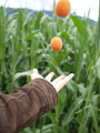
| + | File:2011-07-24 47 7 8 apricot.PNG | Today's menu: apricot (but not all of them) | ||
| + | File:2011-07-24 47 7 9 zastlerbach.PNG | The Zastler creek. How shall I cross? | ||
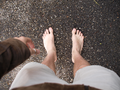
| + | Image::2011-07-24 47 7 10 dry feet.PNG | Hobbit feet stay dry. | ||
| + | Image::2011-07-24 47 7 11 do not like.PNG | Ouch. Not good, even for hobbit feet. | ||
| + | Image:2011-07-24 47 7 12 great flying thing.PNG | A silent beast of the sky turns its great circles in the distance. Is it in search of something? | ||
| + | Image:2011-07-24 47 7 13 next break.PNG | Yay, lunchtime! | ||
| + | Image:2011-07-24 47 7 14 keen.PNG | A keen edge - and food. No foot, though. | ||
| + | Image:2011-07-24 47 7 15 dry and sunny.PNG | Feet still dry. | ||
| + | Image:2011-07-24 47 7 16 drawing close.PNG | Almost there... | ||
| + | Image:2011-07-24 47 7 hashmap.png | The map, it has done its doing. | ||
| + | Image:2011-07-24 47 7 17 hash not corn.PNG | The hash! Not as boring as I thought - there's more than just corn. | ||
| + | Image:2011-07-24_47_7_apricots_ring.png | The strange and mysterious ritual of the ring and the apricots | ||
| + | Image:2011-07-24 47 7 18 ghost hashcat.PNG | A ghostly cat celebrates with me... Too immaterial for my eye to focus | ||
| + | Image:2011-07-24 47 7 19 eyrie warning.PNG | The flying thing's eyrie lies ahead. | ||
| + | Image:2011-07-24 47 7 20 black skeleton steed.PNG | The black riders on their skeleton steed descend from the mountains. | ||
| + | Image:2011-07-24 47 7 21...and in my pocket bind them.PNG | ...and in my pocket bind them. | ||
</gallery> | </gallery> | ||
== Achievements == | == Achievements == | ||
{{#vardefine:ribbonwidth|800px}} | {{#vardefine:ribbonwidth|800px}} | ||
| − | |||
| + | {{Hobbit achievement | ||
| + | | latitude = 47 | ||
| + | | longitude = 7 | ||
| + | | date = 2011-07-24 | ||
| + | | pronoun = his | ||
| + | | name = [[User:Hijackal|Hijackal]] | ||
| + | | image = 2011-07-24 47 7 5 bread.PNG | ||
| + | }} | ||
| − | + | {{No_batteries_geohash | |
| − | + | | latitude = 47 | |
| − | [[ | + | | longitude = 7 |
| + | | date = 2011-07-24 | ||
| + | | name = [[User:Hijackal|Hijackal]] | ||
| + | | image = 2011-07-24 47 7 hashmap.png | ||
| + | }} | ||
| − | + | {{Circus_geohash | |
| + | | latitude = 47 | ||
| + | | longitude = 7 | ||
| + | | date = 2011-07-24 | ||
| + | | name = [[User:Hijackal|Hijackal]] | ||
| + | | image = 2011-07-24_47_7_apricots_ring.png | ||
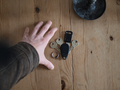
| + | | performance = juggling two apricots in one hand while bearing a ring, baring feet (not pictured) and holding a camera (not pictured) in the other hand | ||
| − | + | }} | |
| − | |||
| − | |||
[[Category:Expeditions]] | [[Category:Expeditions]] | ||
| − | |||
[[Category:Expeditions with photos]] | [[Category:Expeditions with photos]] | ||
| − | + | ||
| − | |||
| − | |||
| − | |||
| − | |||
[[Category:Coordinates reached]] | [[Category:Coordinates reached]] | ||
| − | + | {{location|DE|BW|FR}} | |
| − | |||
| − | |||
| − | |||
| − | |||
| − | |||
| − | |||
| − | |||
| − | |||
| − | |||
Latest revision as of 00:14, 13 August 2019
| Sun 24 Jul 2011 in 47,7: 47.9434130, 7.9556049 geohashing.info google osm bing/os kml crox |
Location
In a corn (?) field 2 km south of Kirchzarten, about 10 km from Freiburg.
Participants
Plans
Hijackal will probably walk there. Maybe barefoot... If anyone wants to suggest a time, he might even bring a game.
Expedition
Soon.
Photos
The plan is made.
Off I go...
Luckily, don't have to go up the Häuseleberg today...
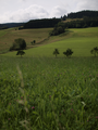
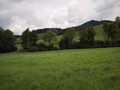
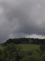
The hills of Hobbitried. Will I return to see them again?
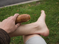
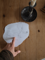
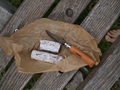
A first break, with fresh bread
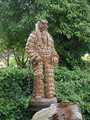
A foreboding wooden guardian. Why is its face frozen in agony?
The next opportunity for a nice meal comes into view
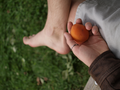
Today's menu: apricot (but not all of them)
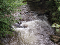
The Zastler creek. How shall I cross?
A silent beast of the sky turns its great circles in the distance. Is it in search of something?
Yay, lunchtime!
A keen edge - and food. No foot, though.
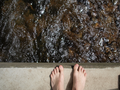
Feet still dry.
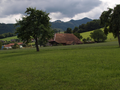
Almost there...
The map, it has done its doing.
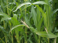
The hash! Not as boring as I thought - there's more than just corn.
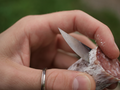
The strange and mysterious ritual of the ring and the apricots
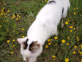
A ghostly cat celebrates with me... Too immaterial for my eye to focus
The flying thing's eyrie lies ahead.
The black riders on their skeleton steed descend from the mountains.
...and in my pocket bind them.


Achievements
Hijackal earned the Hobbit Achievement
|
Hijackal earned the No Batteries Geohash Achievement
|
Hijackal earned the Circus Geohash Achievement
|