Difference between revisions of "2011-07-31 45 -121"
From Geohashing
imported>Michael5000 m (→Location) |
imported>FippeBot m (Location) |
||
| (5 intermediate revisions by one other user not shown) | |||
| Line 1: | Line 1: | ||
| − | |||
<!-- If you did not specify these parameters in the template, please substitute appropriate values for IMAGE, LAT, LON, and DATE (YYYY-MM-DD format) | <!-- If you did not specify these parameters in the template, please substitute appropriate values for IMAGE, LAT, LON, and DATE (YYYY-MM-DD format) | ||
| Line 22: | Line 21: | ||
== Participants == | == Participants == | ||
| − | |||
| − | + | *[[User:Michael5000|Michael5000]] | |
| − | |||
== Expedition == | == Expedition == | ||
| − | |||
| − | + | The Expedition started with an airport dropoff at the unholy hour of 5 a.m., the reasoning being that if I had to be up at that time anyway I might as well take advantage of the empty roads and continue another scenic sixty miles in the same direction to pick up an accessible hashpoint in a new graticule. So that's what I did. | |
| − | + | ||
| + | The hashpoint is a short ways up an embankment from a minor dirt road, perhaps 150 meters off the highway. The forest air smelled great in the cool of the morning. | ||
| + | |||
== Photos == | == Photos == | ||
| − | + | ||
| − | + | ||
| − | |||
<gallery perrow="5"> | <gallery perrow="5"> | ||
| + | File:2011-07-32 45 -121 road.JPG|The old road leading up to the hashpoint. | ||
| + | File:2011-07-32 45 -121 point.JPG|At the hashpoint, looking down at the road. | ||
| + | File:2011-07-32 45 -121 me.JPG|Me, savoring the joy of geohashing. | ||
</gallery> | </gallery> | ||
== Achievements == | == Achievements == | ||
{{#vardefine:ribbonwidth|800px}} | {{#vardefine:ribbonwidth|800px}} | ||
| − | |||
| + | *New Graticule! First attempt and success in [[The Dalles, Oregon]] graticule. | ||
| + | *Second ever successful expedition to [[The Dalles, Oregon]] graticule (by anyone). | ||
| + | *New County! First attempt and success in Wasco County. | ||
| + | *<b>Personal record:</b> Earliest Geohash -- I reached the hashpoint at 6:50 a.m. | ||
| + | *<b>Personal record:</b> With 15 expeditions, July 2011 is my most active geohashing month. Eight successful expeditions makes it the second-best month ever in that category. | ||
| − | + | {{Minesweeper geohash | |
| − | + | | graticule = [[Portland, Oregon]] | |
| − | [[ | + | | ranknumber = 5 |
| + | | ne = true if graticule to the northeast has been hashed (optional) | ||
| + | | e = true if graticule to the east has been hashed (optional) | ||
| + | | sw = true if graticule to the southwest has been hashed (optional) | ||
| + | | w = true if graticule to the west has been hashed (optional) | ||
| + | | nw = true if graticule to the northwest has been hashed (optional) | ||
| + | | name = [[User:Michael5000|Michael5000]] | ||
| + | }} | ||
| − | |||
| − | |||
| − | |||
| − | |||
| − | |||
| − | |||
[[Category:Expeditions]] | [[Category:Expeditions]] | ||
| − | |||
[[Category:Expeditions with photos]] | [[Category:Expeditions with photos]] | ||
| − | |||
| − | |||
| − | |||
| − | |||
| − | |||
[[Category:Coordinates reached]] | [[Category:Coordinates reached]] | ||
| − | + | {{location|US|OR|WC}} | |
| − | |||
| − | |||
| − | |||
| − | |||
| − | |||
| − | |||
| − | |||
| − | |||
| − | |||
Latest revision as of 00:17, 13 August 2019
| Sun 31 Jul 2011 in 45,-121: 45.0563467, -121.5150552 geohashing.info google osm bing/os kml crox |
Location
Just off of Highway 26, twenty-five miles north of Warm Springs.
Participants
Expedition
The Expedition started with an airport dropoff at the unholy hour of 5 a.m., the reasoning being that if I had to be up at that time anyway I might as well take advantage of the empty roads and continue another scenic sixty miles in the same direction to pick up an accessible hashpoint in a new graticule. So that's what I did.
The hashpoint is a short ways up an embankment from a minor dirt road, perhaps 150 meters off the highway. The forest air smelled great in the cool of the morning.
Photos
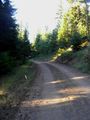
The old road leading up to the hashpoint.
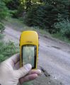
At the hashpoint, looking down at the road.

Me, savoring the joy of geohashing.


Achievements
- New Graticule! First attempt and success in The Dalles, Oregon graticule.
- Second ever successful expedition to The Dalles, Oregon graticule (by anyone).
- New County! First attempt and success in Wasco County.
- Personal record: Earliest Geohash -- I reached the hashpoint at 6:50 a.m.
- Personal record: With 15 expeditions, July 2011 is my most active geohashing month. Eight successful expeditions makes it the second-best month ever in that category.
Michael5000 achieved level 5 of the Minesweeper Geohash achievement
|