Difference between revisions of "2011-08-09 49 12"
imported>Dawidi (mini-writeup and photos) |
imported>FippeBot m (Location) |
||
| Line 32: | Line 32: | ||
[[Category:Expeditions with photos]] | [[Category:Expeditions with photos]] | ||
[[Category:Coordinates reached]] | [[Category:Coordinates reached]] | ||
| + | {{location|DE|BY|R}} | ||
Latest revision as of 00:24, 13 August 2019
| Tue 9 Aug 2011 in Regensburg, Germany: 49.0458297, 12.0792654 geohashing.info google osm bing/os kml crox |
In a field between Kareth and Lappersdorf, just north of Regensburg.
Tomcat and dawidi
... went to the coordinates in the evening, incorporating it into one of their traditional after-work geocache rounds.
On the way they had to pause a few minutes before getting to the hash, taking cover from a short, but intense rain shower; after it stopped raining, a beautiful, complete rainbow appeared over the landscape. Stomping through the recently tilled and very sticky field, they found a heart-shaped Google maps-style marker at the exact coordinates. dawidi was pretty excited and totally forgot to take a picture of the GPS.
A film canister on the back of the marker contained written greetings to them, from mojibake - she had reached the hash two hours earlier, and luckily also remembered to photograph her GPS for proof :-)
After a few minutes, Tomcat and dawidi went back out of the field, partially moved the mud from their shoes to the road/cycleway and continued their geocaching round.
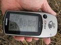
mojibake reached the coordinates first...

... and left a marker.


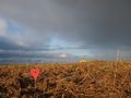
So that's what you find at the end of a rainbow:
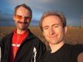
Happy hashers!

dawidi posing with the marker.

Making a mess, back at the road.


