Difference between revisions of "2011-08-25 45 -122"
imported>Jiml m (Add tracklog info) |
imported>FippeBot m (Location) |
||
| Line 57: | Line 57: | ||
[[Category:Expeditions with photos]] | [[Category:Expeditions with photos]] | ||
[[Category:Coordinates reached]] | [[Category:Coordinates reached]] | ||
| + | {{location|US|WA|SM}} | ||
Latest revision as of 00:36, 13 August 2019
| Thu 25 Aug 2011 in 45,-122: 45.7747264, -122.0248838 geohashing.info google osm bing/os kml crox |
Location
Skamania Co, up Rock Creek with no paddle.
Participants
Plans
Quit my chores, go walking.
Expedition
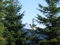
A nice trip, only 10 mi from home and about 1/4 mi walking. Good view of Mt Hood, different from the normal Portland one. AND BIG BONUS !! found a good swimming hole with a waterfall.
Tracklog
How does one do this ? Just upload as if it were a photo ? What format (file extention)? - Kydlt
- I think most folks upload it to, say, everytrail.com, and put a link to the trip here. Jiml 11:02, 27 August 2011 (EDT)
Photos
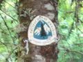
Any trip that you can step onto the PCT is a good trip.
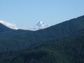
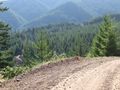
Any trip that you can see Mt Hood is a good trip.
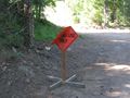
The sign looks pretty good for being ran over with a log truck.
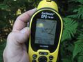
Now I used an X when I enter in the waypoint that I'm going to.
I think that it was 400-500 vertical feet. I need to look at the notes.
I just love the snow tops.
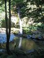
AND I found a new swimming hole, only 20 minutes from home.


Achievements
- Land Geohash