Difference between revisions of "2011-08-27 50 8"
imported>Mampfred ([live picture] Hash Art) |
imported>FippeBot m (Location) |
||
| (3 intermediate revisions by one other user not shown) | |||
| Line 1: | Line 1: | ||
| − | |||
| − | |||
| − | |||
| − | |||
| − | |||
| − | |||
| − | |||
| − | |||
| − | |||
| − | |||
{{meetup graticule | {{meetup graticule | ||
| lat=50 | | lat=50 | ||
| Line 15: | Line 5: | ||
}} | }} | ||
| − | |||
__NOTOC__ | __NOTOC__ | ||
== Location == | == Location == | ||
| − | + | In the woods next to Hohenstein. | |
== Participants == | == Participants == | ||
| − | + | * [[User:Mampfred|Mampfred]] | |
| + | * [[User:LadyBB|LadyBB]] + MJ | ||
| + | * [[User:QuarterCacher|QuarterCacher]] | ||
| + | * [[User:M|M]] | ||
== Plans == | == Plans == | ||
| − | + | On friday, we (Mampfred and Rincewind) noticed that the [[2011-08-27 50 8|saturday]] and [[2011-08-28 50 8|sunday]] hashes are quite close. We'd done consecutives before by going to one hash around 10pm and heading on to the next one for a midnight achievement, so we both planned for different graticules (Rincewind went for [[2011-08-27 51 11|this]] [[2011-08-28 51 11|one]]). | |
| + | |||
| + | On saturday, Mampfred had a chat with Quartercacher and was up for it as well and would bring M along as well. | ||
== Expedition == | == Expedition == | ||
| − | + | Later that night, LadyBB decided to join us as well (Mampfred has decided to call her LadyCC from now on for completely crazy, she's less than two weeks away from welcoming MJ). We met at 9:30pm and went for a 40 minute drive to the first hash. | |
| + | Found a little parking lot in the woods quite close to the hash. Fortunately QuarterCacher has very detailed hiking maps on his GPS so we were able to use proper paths for most of the way. It had been raining all day but thankfully there was only a light drizzle left and being in the woods not much of that actually reached us. It's an amazing experience every time if you're walking through the woods in pitch black with a couple of torches. From the path the hash was a mere 40 meters into the woods. Time of arrival was 10:36pm. We grabbed a couple of screenshots and took a stupid grin photo and headed back to the car for the [[2011-08-28 50 8|second hash of the night ...]] | ||
| − | |||
== Tracklog == | == Tracklog == | ||
| − | + | See [http://www.everytrail.com/view_trip.php?trip_id=1264714 here]. | |
== Photos == | == Photos == | ||
| − | |||
| − | |||
| − | |||
<gallery perrow="5"> | <gallery perrow="5"> | ||
| − | + | Image:2011-08-27_50_8_22-10-25-295.jpg | Hash Art (in the car on the way) | |
| − | Image:2011-08-27_50_8_22-10-25-295.jpg | Hash Art | + | Image:2011-08-27_50_8_coordinates.jpeg | Coordinates ... |
| + | Image:2011-08-27_50_8_reached.jpeg | ... reached | ||
| + | Image:2011-08-27_50_8_hash_droid.jpeg | Hash Droid agrees | ||
| + | Image:2011-08-27_50_8_grin.jpeg | Stupid grin | ||
</gallery> | </gallery> | ||
== Achievements == | == Achievements == | ||
{{#vardefine:ribbonwidth|800px}} | {{#vardefine:ribbonwidth|800px}} | ||
| − | + | {{Land geohash | |
| + | | latitude = 50 | ||
| + | | longitude = 8 | ||
| + | | date = 2011-08-27 | ||
| + | | name = Mampfred, QuarterCacher, M and LadyBB +MJ | ||
| + | }} | ||
| − | |||
| − | |||
| − | |||
| − | |||
| − | |||
| − | |||
| − | |||
| − | |||
| − | |||
| − | |||
| − | |||
[[Category:Expeditions]] | [[Category:Expeditions]] | ||
| − | |||
[[Category:Expeditions with photos]] | [[Category:Expeditions with photos]] | ||
| − | |||
| − | |||
| − | |||
| − | |||
| − | |||
[[Category:Coordinates reached]] | [[Category:Coordinates reached]] | ||
| − | + | {{location|DE|HE|SWA}} | |
| − | |||
| − | |||
| − | |||
| − | |||
| − | |||
| − | |||
| − | |||
| − | |||
| − | |||
Latest revision as of 00:38, 13 August 2019
| Sat 27 Aug 2011 in 50,8: 50.1807526, 8.0797592 geohashing.info google osm bing/os kml crox |
Location
In the woods next to Hohenstein.
Participants
- Mampfred
- LadyBB + MJ
- QuarterCacher
- M
Plans
On friday, we (Mampfred and Rincewind) noticed that the saturday and sunday hashes are quite close. We'd done consecutives before by going to one hash around 10pm and heading on to the next one for a midnight achievement, so we both planned for different graticules (Rincewind went for this one).
On saturday, Mampfred had a chat with Quartercacher and was up for it as well and would bring M along as well.
Expedition
Later that night, LadyBB decided to join us as well (Mampfred has decided to call her LadyCC from now on for completely crazy, she's less than two weeks away from welcoming MJ). We met at 9:30pm and went for a 40 minute drive to the first hash.
Found a little parking lot in the woods quite close to the hash. Fortunately QuarterCacher has very detailed hiking maps on his GPS so we were able to use proper paths for most of the way. It had been raining all day but thankfully there was only a light drizzle left and being in the woods not much of that actually reached us. It's an amazing experience every time if you're walking through the woods in pitch black with a couple of torches. From the path the hash was a mere 40 meters into the woods. Time of arrival was 10:36pm. We grabbed a couple of screenshots and took a stupid grin photo and headed back to the car for the second hash of the night ...
Tracklog
See here.
Photos

Hash Art (in the car on the way)
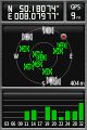
Coordinates ...

... reached
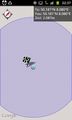
Hash Droid agrees
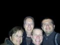
Stupid grin


Achievements
Mampfred, QuarterCacher, M and LadyBB +MJ earned the Land geohash achievement
|