Difference between revisions of "2011-09-16 48 11"
imported>Gefrierbrand m |
imported>FippeBot m (Location) |
||
| (5 intermediate revisions by 2 users not shown) | |||
| Line 14: | Line 14: | ||
}} | }} | ||
| − | + | ||
__NOTOC__ | __NOTOC__ | ||
== Location == | == Location == | ||
| − | + | At the edge of an field not far from a major road near Herdweg. | |
| − | + | ||
== Participants == | == Participants == | ||
| − | + | ||
| − | [[User:Gefrierbrand|Gefrierbrand]] | + | * [[User:Gefrierbrand|Gefrierbrand]] |
== Plans == | == Plans == | ||
| − | + | ||
| − | I | + | I had already noticed yesterday that this hash was quite near (150m) to the road |
| + | I could take anyway so I decided to head there on my way home from work. | ||
== Expedition == | == Expedition == | ||
| − | |||
| − | + | There are several routes I can take to get home from work. The hash was near the one | |
| − | + | I almost never use. | |
| + | |||
| + | Nevertheless, I started driving in the general direction and to my "pleasure", Google | ||
| + | Maps did not know the road I was driving on even existed and insisted I should turn back | ||
| + | where save. Luckily, I had roadsigns to follow and have been in the area before. So | ||
| + | reaching the point was quite easy. | ||
| + | |||
| + | I parked somewhere near the location and headed in the general direction which I still had in | ||
| + | mind from the satellite images. As in both my previous expeditions, the final location was | ||
| + | very near to a corn field. | ||
| + | |||
| + | This time, I used my Laptop with an USB GPS receiver as I again had only my cellphone for | ||
| + | pictures (and the GPS reception was way better than using the cellphone). | ||
| + | Quickly, I had to learn it's rather hard to walk the last few meters staring only at the | ||
| + | changing numbers of CGPS, so I fired up Navit. Therefore I had to fiddle with my Netbook | ||
| + | sitting on a lawn and trying to set the target location as a bookmark in Navit. But the | ||
| + | bookmark locations are stored as degrees while the hash location is given in decimals. | ||
| + | I had no nerve to do the necessary calculations on the spot and simply went for it and | ||
| + | walked right into the field. To my delight the phone GPS reception got better there | ||
| + | and I could look at two devices pinpointing my location at the same time. I'm | ||
| + | pretty sure I looked very silly at that moment. | ||
| + | |||
| + | I put my netbook down exactly at the hashpoint to take some | ||
| + | pictures as I notices an old piece of junk, which I picked up of course. | ||
| + | As I was ready to leave the area, my view came across an even bigger part | ||
| + | of trash in a neighboring willow so I stopped to pick it up as well. | ||
== Photos == | == Photos == | ||
| − | + | ||
| − | |||
| − | |||
<gallery perrow="5"> | <gallery perrow="5"> | ||
| + | |||
| + | File:2011-09-16 13.28.32.jpg | The general area around the hash. You can see another corn field in the background. | ||
| + | File:2011-09-16 13.28.26.jpg | Quite a pleasant region | ||
| + | File:2011-09-16 13.43.54.jpg | Me at the final location | ||
| + | File:2011-09-16 13.43.14.jpg | My tracking device. And trash to pick up underneath the cable | ||
| + | File:2011-09-16 13.56.11.jpg | Another piece of paper I picked up ... | ||
| + | File:2011-09-16 13.56.38.jpg | ... The word "TEMPEL" was drawn on it, and there were some signatures I could not make out. | ||
| + | File:Bildschirmfoto-1.png | Screenshot taken at the hash location. Navit's display is a bit off as I forgot to turn off the snap to street feature | ||
</gallery> | </gallery> | ||
== Achievements == | == Achievements == | ||
{{#vardefine:ribbonwidth|800px}} | {{#vardefine:ribbonwidth|800px}} | ||
| − | |||
| + | {{land geohash | ||
| + | | latitude = 48 | ||
| + | | longitude = 11 | ||
| + | | date = 2011-09-16 | ||
| + | | name = Gefrierbrand | ||
| + | }} | ||
| + | {{Geotrash | ||
| + | | latitude = 48 | ||
| + | | longitude = 11 | ||
| + | | date = 2011-09-16 | ||
| + | | name = Gefrierbrand | ||
| + | }} | ||
| − | |||
| − | |||
| − | |||
| − | |||
| − | |||
| − | |||
| − | |||
| − | |||
| − | |||
[[Category:Expeditions]] | [[Category:Expeditions]] | ||
| − | |||
[[Category:Expeditions with photos]] | [[Category:Expeditions with photos]] | ||
| − | |||
| − | |||
| − | |||
| − | |||
| − | |||
[[Category:Coordinates reached]] | [[Category:Coordinates reached]] | ||
| − | + | {{location|DE|BY|EBE}} | |
| − | |||
| − | |||
| − | |||
| − | |||
| − | |||
| − | |||
| − | |||
| − | |||
| − | |||
Latest revision as of 00:51, 13 August 2019
| Fri 16 Sep 2011 in 48,11: 48.1994434, 11.8775460 geohashing.info google osm bing/os kml crox |
Location
At the edge of an field not far from a major road near Herdweg.
Participants
Plans
I had already noticed yesterday that this hash was quite near (150m) to the road I could take anyway so I decided to head there on my way home from work.
Expedition
There are several routes I can take to get home from work. The hash was near the one I almost never use.
Nevertheless, I started driving in the general direction and to my "pleasure", Google Maps did not know the road I was driving on even existed and insisted I should turn back where save. Luckily, I had roadsigns to follow and have been in the area before. So reaching the point was quite easy.
I parked somewhere near the location and headed in the general direction which I still had in mind from the satellite images. As in both my previous expeditions, the final location was very near to a corn field.
This time, I used my Laptop with an USB GPS receiver as I again had only my cellphone for pictures (and the GPS reception was way better than using the cellphone). Quickly, I had to learn it's rather hard to walk the last few meters staring only at the changing numbers of CGPS, so I fired up Navit. Therefore I had to fiddle with my Netbook sitting on a lawn and trying to set the target location as a bookmark in Navit. But the bookmark locations are stored as degrees while the hash location is given in decimals. I had no nerve to do the necessary calculations on the spot and simply went for it and walked right into the field. To my delight the phone GPS reception got better there and I could look at two devices pinpointing my location at the same time. I'm pretty sure I looked very silly at that moment.
I put my netbook down exactly at the hashpoint to take some pictures as I notices an old piece of junk, which I picked up of course. As I was ready to leave the area, my view came across an even bigger part of trash in a neighboring willow so I stopped to pick it up as well.
Photos
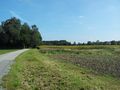
The general area around the hash. You can see another corn field in the background.
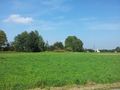
Quite a pleasant region

Me at the final location
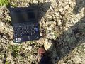
My tracking device. And trash to pick up underneath the cable
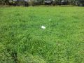
Another piece of paper I picked up ...
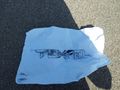
... The word "TEMPEL" was drawn on it, and there were some signatures I could not make out.
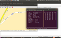
Screenshot taken at the hash location. Navit's display is a bit off as I forgot to turn off the snap to street feature


Achievements
Gefrierbrand earned the Land geohash achievement
|
Gefrierbrand earned the GeoTrash Geohash Achievement
|