Difference between revisions of "2011-09-17 42 -114"
imported>Michael5000 (Created page with "{{subst:Expedition |lat = 42 |lon = -114 |date = 2011-09-17 42 -114 }}") |
m (per Renaming Proposal) |
||
| (9 intermediate revisions by 2 users not shown) | |||
| Line 1: | Line 1: | ||
| − | |||
| − | |||
| − | |||
| − | |||
| − | |||
| − | |||
| − | |||
| − | |||
| − | |||
| − | |||
{{meetup graticule | {{meetup graticule | ||
| lat=42 | | lat=42 | ||
| lon=-114 | | lon=-114 | ||
| − | | date=2011-09-17 | + | | date=2011-09-17 |
}} | }} | ||
| − | + | [[File:2011-09-17 42 -114 5.JPG|thumb|none|600 px|The Snake River Valley in late summer.]] | |
| + | |||
| + | |||
__NOTOC__ | __NOTOC__ | ||
== Location == | == Location == | ||
| − | + | ||
| + | In the Snake River Canyon just south of Hagerman. | ||
== Participants == | == Participants == | ||
| − | |||
| − | + | *[[User:Michael5000|Michael5000]] | |
| − | |||
== Expedition == | == Expedition == | ||
| − | |||
| − | + | After three expeditions in a row where places shown by Google Maps as accessible by rural roads turned out to be very difficult or nearly impossible to get to, this one came as a bit of a surprise: I drove up a short rural road, parked, and walked a few meters out into a field. Mission accomplished! | |
| − | + | ||
| + | The spot was in the lush Snake River Canyon, and when I arrived at the end of a long day of driving the farms and canyon walls were lit with beautiful golden light from the setting sun. To get across the river from the more densely populated north side I had to drive across a decrepit old bridge, restricted to one lane of non-truck traffic and seemingly unpaved for decades; even it looked enchanting in the evening light. Of all the hashpoints I've been too, this place was probably the most bucolic -- not necessarily the most beautiful, but the ''sweetest''. | ||
== Photos == | == Photos == | ||
| − | + | ||
| − | |||
| − | |||
<gallery perrow="5"> | <gallery perrow="5"> | ||
| + | File:2011-09-17 42 -114 1.JPG|The turnoff from U.S. Highway 30. | ||
| + | File:2011-09-17 42 -114 2.JPG|A picturesque but not entirely confidence-inspiring bridge. | ||
| + | File:2011-09-17 42 -114 3.JPG|This hashpoint really WAS next to a road! | ||
| + | File:2011-09-17 42 -114 4.JPG|I haz GPS. | ||
| + | File:2011-09-17 42 -114 5.JPG|The Snake River Valley in late summer. | ||
| + | File:2011-09-17 42 -114 6.JPG|The Bear enjoys that ineffable sensation of being AT the hashpoint. | ||
</gallery> | </gallery> | ||
== Achievements == | == Achievements == | ||
{{#vardefine:ribbonwidth|800px}} | {{#vardefine:ribbonwidth|800px}} | ||
| − | |||
| + | *Set record for my easternmost geohash. | ||
| + | *Fifth Expedition of the [[Endurance Geohashing]] series. | ||
| + | |||
| − | + | {{Graticule unlocked | |
| − | + | | latitude = 42 | |
| − | [[ | + | | longitude = -114 |
| + | | date = 2011-09-17 | ||
| + | | name = [[User:Michael5000|Michael5000]] | ||
| + | | image = 2011-09-17 42 -114 2.JPG | ||
| + | }} | ||
| − | + | *Only the fourth graticule to be hashed in the state of Idaho! | |
| − | |||
| − | |||
| − | |||
| − | |||
[[Category:Expeditions]] | [[Category:Expeditions]] | ||
| − | |||
[[Category:Expeditions with photos]] | [[Category:Expeditions with photos]] | ||
| − | |||
| − | |||
| − | |||
| − | |||
| − | |||
[[Category:Coordinates reached]] | [[Category:Coordinates reached]] | ||
| − | + | {{location|US|ID|TW}} | |
| − | |||
| − | |||
| − | |||
| − | |||
| − | |||
| − | |||
| − | |||
| − | |||
| − | |||
Latest revision as of 05:49, 20 March 2024
| Sat 17 Sep 2011 in 42,-114: 42.7586070, -114.8922134 geohashing.info google osm bing/os kml crox |

Location
In the Snake River Canyon just south of Hagerman.
Participants
Expedition
After three expeditions in a row where places shown by Google Maps as accessible by rural roads turned out to be very difficult or nearly impossible to get to, this one came as a bit of a surprise: I drove up a short rural road, parked, and walked a few meters out into a field. Mission accomplished!
The spot was in the lush Snake River Canyon, and when I arrived at the end of a long day of driving the farms and canyon walls were lit with beautiful golden light from the setting sun. To get across the river from the more densely populated north side I had to drive across a decrepit old bridge, restricted to one lane of non-truck traffic and seemingly unpaved for decades; even it looked enchanting in the evening light. Of all the hashpoints I've been too, this place was probably the most bucolic -- not necessarily the most beautiful, but the sweetest.
Photos
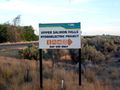
The turnoff from U.S. Highway 30.
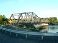
A picturesque but not entirely confidence-inspiring bridge.
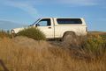
This hashpoint really WAS next to a road!
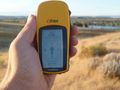
I haz GPS.
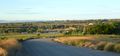
The Snake River Valley in late summer.
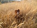
The Bear enjoys that ineffable sensation of being AT the hashpoint.


Achievements
- Set record for my easternmost geohash.
- Fifth Expedition of the Endurance Geohashing series.
Michael5000 earned the Graticule Unlocked Achievement
|
- Only the fourth graticule to be hashed in the state of Idaho!