Difference between revisions of "2011-09-17 43 -115"
imported>Michael5000 (Created page with "{{subst:Expedition |lat = 43 |lon = -115 |date = 2011-09-17 }}") |
m (per Renaming Proposal) |
||
| (13 intermediate revisions by 2 users not shown) | |||
| Line 1: | Line 1: | ||
| − | |||
<!-- If you did not specify these parameters in the template, please substitute appropriate values for IMAGE, LAT, LON, and DATE (YYYY-MM-DD format) | <!-- If you did not specify these parameters in the template, please substitute appropriate values for IMAGE, LAT, LON, and DATE (YYYY-MM-DD format) | ||
| Line 18: | Line 17: | ||
__NOTOC__ | __NOTOC__ | ||
== Location == | == Location == | ||
| − | + | ||
| + | In wooded hills south of Idaho City. | ||
== Participants == | == Participants == | ||
| − | |||
| − | + | *[[User:Michael5000|Michael5000]] | |
| − | |||
== Expedition == | == Expedition == | ||
| − | |||
| − | + | For the second time in two days, Google Maps suggested that I would be able to all but drive up and park at a rural hashpoint. I knew it wasn't true from the aerial imagery, but it looked like it might not take more than a casual stroll through light forest. Fooled again. | |
| − | + | ||
| + | It's not that the forests of the Northwest are trackless, untouched wilderness. On the contrary, they have all been crisscrossed over the last 150 years by several generations of logging roads. The trouble is, most maps draw on a database -- probably county cadastral maps -- that make no distinction between good highway and a semi-accurate road plan filed by some timber company surveyor in 1925 that hasn't seen a wheeled vehicle since the Hoover Administration. | ||
| + | |||
| + | Well. This particular expedition took some false starts before I found that the closest drive-in point was about 2/3 of a mile from the hashpoint. From there, I thrashed about in the woods for a bit before noting an old graded roadway upslope from me. I trudged up 200 feet of steep slope, breaking a sweat and sucking mountain air like the sea-level dweller I am. | ||
| + | |||
| + | Despite being inaccessible in its lower reaches, this road still had an artifact gate -- it's hardly a rural geohash without a gated road -- and then went on a bit before forking. By far the more accessible branch went away from the hashpoint and down, so I wisely took the road less traveled, which went in the correct direction and maintained altitude. Bad choice. Soon I was following animal tracks up, down, and across steep wooded slopes, using my keys as improvised bear bells and wondering why on earth I had ever taken up this hobby. | ||
| + | |||
| + | But, I eventually found a passable trail that brought me to within two hundred feet of the hashpoint. The way was clear! The hashpoint was in an open meadow! That sloped at about fifty degrees! Wheezing, I trudged up the last stretch twenty feet at a time. Have I mentioned, I had already run an 8 kilometer race earlier in the morning? | ||
| + | |||
| + | The way out was much easier than the way in. I found a much smoother and more passable trail, which turned out to be -- of course -- the branch of the road that I thought would take me in the wrong direction. All told, the 1 1/3 mile walk from the truck and back took me a full 50 minutes. | ||
== Photos == | == Photos == | ||
| − | |||
| − | |||
| − | |||
<gallery perrow="5"> | <gallery perrow="5"> | ||
| + | File:2011-09-17 43 -115 1.JPG|The relic gate | ||
| + | File:2011-09-17 43 -115 2.JPG|The fork in the road. Really, the right-hand path looked better on the map. | ||
| + | File:2011-09-17 43 -115 3.JPG|This is the kind of thing that gets marked as a "road" on rural maps. | ||
| + | File:2011-09-17 43 -115 4.JPG|The hashpoint, in all its steep, steep glory. | ||
| + | File:2011-09-17 43 -115 5.JPG|But I got there. | ||
| + | File:2011-09-17 43 -115 6.JPG|Not much the worse for wear. | ||
| + | File:2011-09-17 43 -115 7.JPG|Looking straight down from the hashpoint. | ||
| + | File:2011-09-17 43 -115 8.JPG|It is alway nice to make it back to the truck. | ||
</gallery> | </gallery> | ||
== Achievements == | == Achievements == | ||
{{#vardefine:ribbonwidth|800px}} | {{#vardefine:ribbonwidth|800px}} | ||
| − | |||
| + | *Set record for my easternmost geohash; but the record would be broken again eight hours later. | ||
| + | *Fourth Expedition of the [[Endurance Geohashing]] series. | ||
| + | *My third state! | ||
| + | |||
| + | {{Graticule unlocked | ||
| + | | latitude = 43 | ||
| + | | longitude = -115 | ||
| + | | date = 2011-09-17 | ||
| + | | name = [[User:Michael5000|Michael5000]] | ||
| + | | image = 2011-09-17 43 -115 5.JPG | ||
| + | }} | ||
| + | |||
| + | *Only the third graticule to be hashed in the state of Idaho! | ||
| − | |||
| − | |||
| − | |||
| − | |||
| − | |||
| − | |||
| − | |||
| − | |||
[[Category:Expeditions]] | [[Category:Expeditions]] | ||
| − | |||
[[Category:Expeditions with photos]] | [[Category:Expeditions with photos]] | ||
| − | |||
| − | |||
| − | |||
| − | |||
| − | |||
[[Category:Coordinates reached]] | [[Category:Coordinates reached]] | ||
| − | + | {{location|US|ID|BS}} | |
| − | |||
| − | |||
| − | |||
| − | |||
| − | |||
| − | |||
| − | |||
| − | |||
| − | |||
Latest revision as of 05:49, 20 March 2024
| Sat 17 Sep 2011 in 43,-115: 43.7586070, -115.8922134 geohashing.info google osm bing/os kml crox |
Location
In wooded hills south of Idaho City.
Participants
Expedition
For the second time in two days, Google Maps suggested that I would be able to all but drive up and park at a rural hashpoint. I knew it wasn't true from the aerial imagery, but it looked like it might not take more than a casual stroll through light forest. Fooled again.
It's not that the forests of the Northwest are trackless, untouched wilderness. On the contrary, they have all been crisscrossed over the last 150 years by several generations of logging roads. The trouble is, most maps draw on a database -- probably county cadastral maps -- that make no distinction between good highway and a semi-accurate road plan filed by some timber company surveyor in 1925 that hasn't seen a wheeled vehicle since the Hoover Administration.
Well. This particular expedition took some false starts before I found that the closest drive-in point was about 2/3 of a mile from the hashpoint. From there, I thrashed about in the woods for a bit before noting an old graded roadway upslope from me. I trudged up 200 feet of steep slope, breaking a sweat and sucking mountain air like the sea-level dweller I am.
Despite being inaccessible in its lower reaches, this road still had an artifact gate -- it's hardly a rural geohash without a gated road -- and then went on a bit before forking. By far the more accessible branch went away from the hashpoint and down, so I wisely took the road less traveled, which went in the correct direction and maintained altitude. Bad choice. Soon I was following animal tracks up, down, and across steep wooded slopes, using my keys as improvised bear bells and wondering why on earth I had ever taken up this hobby.
But, I eventually found a passable trail that brought me to within two hundred feet of the hashpoint. The way was clear! The hashpoint was in an open meadow! That sloped at about fifty degrees! Wheezing, I trudged up the last stretch twenty feet at a time. Have I mentioned, I had already run an 8 kilometer race earlier in the morning?
The way out was much easier than the way in. I found a much smoother and more passable trail, which turned out to be -- of course -- the branch of the road that I thought would take me in the wrong direction. All told, the 1 1/3 mile walk from the truck and back took me a full 50 minutes.
Photos
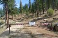
The relic gate
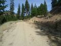
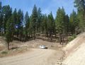
The fork in the road. Really, the right-hand path looked better on the map.
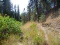
This is the kind of thing that gets marked as a "road" on rural maps.
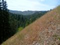
The hashpoint, in all its steep, steep glory.
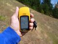
But I got there.

Not much the worse for wear.
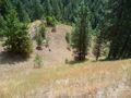
Looking straight down from the hashpoint.
It is alway nice to make it back to the truck.


Achievements
- Set record for my easternmost geohash; but the record would be broken again eight hours later.
- Fourth Expedition of the Endurance Geohashing series.
- My third state!
Michael5000 earned the Graticule Unlocked Achievement
|
- Only the third graticule to be hashed in the state of Idaho!