Difference between revisions of "2011-09-19 44 -120"
imported>Michael5000 m |
imported>FippeBot m (Location) |
||
| (8 intermediate revisions by one other user not shown) | |||
| Line 5: | Line 5: | ||
}} | }} | ||
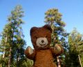
| − | [[File:2011-09- | + | [[File:2011-09-19 44 -120 (6).JPG|thumb|left|300 px|I photograph me, at the hashpoint.]] |
| Line 11: | Line 11: | ||
== Location == | == Location == | ||
| + | Deep in the Ochoco National Forest. | ||
| Line 20: | Line 21: | ||
== Expedition == | == Expedition == | ||
| + | '''Driving In''' | ||
| + | |||
| + | In a U.S. National Forest, you never really know how difficult a hashpoint is going to be. Maps and even aerial images don't really give you much of a feel for how good a road is, and even if you know the general system of numbering there's still a lot of guesswork involved. | ||
| + | |||
| + | In this case, a good two-lane gravel road brought me to about five miles from the hashpoint, and a clearly marked and signposted link road led from there to near the place I intended to park. This second road was very driveable until suddenly it wasn't, and I found myself crawling across stonefields, deep ruts, and holes of a kind that would give most people with 4-wheel drive (which my truck does not have) serious pause. It had snuck up on me so abruptly that I was in the thick of it, with no way of turning around, before I knew what had happened, and so extreme that I wondered if I had wandered onto a dead-end spur. I began to sweat profusely from worry, wondering how much time, money, and humiliation it would take to have a stranded vehicle retrieved from this deep in the forest. | ||
| + | |||
| + | As I considered stopping in order to hike both forwards and backwards to see which direction would be more likely to be survivable for the truck, I rounded a corner to see... a woman walking two dogs. I stopped and looked again. She was still there. She told me that the road I was on really did get to a properly surfaced road a little further down. So, enjoying my visit to the land of the surreal, I drove through the rockfields and ruts with more confidence. It's a Toyota, after all. | ||
| + | |||
| + | '''Hiking In''' | ||
| + | |||
| + | I could have actually driven to as close as half a mile from the hashpoint, but it was on a marginal road and I was still scarred by my experience of a few minutes before. So, I began a hike in from 1 1/4 miles. After a stiff climb of 1/2 mile, the road reached a T intersection about 3/4 of a mile from the hashpoint, each of the branches of the T heading off laterally from the direction I was heading in. Sighing, I began hiking in cross-country. It was tough going, with steep uphills and downhills through woods and meadows. Three times I crossed roads heading perfectly perpendicular to the direction I was heading, and at one point I had to duck through a barbed-wire stock fence. I was occasionally rewarded, though, by glimpses of (what must be, according to the map) Big Summit Prairie off in the distance, through the trees. | ||
| + | |||
| + | Reaching a hashpoint usually happens without much accompanying drama, but in this case when I arrived on the scene a deer bounded off into the deeper woods and an owl swept grandly down from some high perch and away into the forest. It was quite something. And then I did the usual photograph-and-retreat. | ||
| + | |||
| + | On my way out, I confirmed a suspicion that had been nagging at me: those perpendicular roads I had kept crossing were in fact the original road I had started up, winding back and forth across my direct-line path like some great dollar sign. I followed it back down to the truck and had a much easier time of it. | ||
== Photos == | == Photos == | ||
| − | |||
| − | |||
| − | |||
<gallery perrow="5"> | <gallery perrow="5"> | ||
| + | File:2011-09-19 44 -120 1.JPG|I walked up this road, which is MUCH MUCH better than the road I had just driven. | ||
| + | File:2011-09-19 44 -120 2.JPG|Occasional interesting views through the trees. | ||
| + | File:2011-09-19 44 -120 3.JPG|Traditional GPS shot. | ||
| + | File:2011-09-19 44 -120 4.JPG|The forests are filled with dangers. | ||
| + | File:2011-09-19 44 -120 (6).JPG|But the most dangerous animal.... | ||
</gallery> | </gallery> | ||
| Line 32: | Line 50: | ||
{{#vardefine:ribbonwidth|800px}} | {{#vardefine:ribbonwidth|800px}} | ||
<!-- Add any achievement ribbons you earned below, or remove this section --> | <!-- Add any achievement ribbons you earned below, or remove this section --> | ||
| + | {{Multihash2 | count = 4 | date = 2011-09-19 | name = [[User:Michael5000|Michael5000]]}} | ||
| + | * Six attempts and four successes in one long day. | ||
| − | |||
| − | |||
| − | |||
| − | |||
| − | |||
| − | |||
| − | |||
| − | |||
[[Category:Expeditions]] | [[Category:Expeditions]] | ||
| − | |||
[[Category:Expeditions with photos]] | [[Category:Expeditions with photos]] | ||
| − | |||
| − | |||
| − | |||
| − | |||
| − | |||
[[Category:Coordinates reached]] | [[Category:Coordinates reached]] | ||
| − | + | {{location|US|OR|CR}} | |
| − | |||
| − | |||
| − | |||
| − | |||
| − | |||
| − | |||
| − | |||
| − | |||
| − | |||
Latest revision as of 00:55, 13 August 2019
| Mon 19 Sep 2011 in 44,-120: 44.4223289, -120.2688817 geohashing.info google osm bing/os kml crox |
.JPG)
Location
Deep in the Ochoco National Forest.
Participants
Expedition
Driving In
In a U.S. National Forest, you never really know how difficult a hashpoint is going to be. Maps and even aerial images don't really give you much of a feel for how good a road is, and even if you know the general system of numbering there's still a lot of guesswork involved.
In this case, a good two-lane gravel road brought me to about five miles from the hashpoint, and a clearly marked and signposted link road led from there to near the place I intended to park. This second road was very driveable until suddenly it wasn't, and I found myself crawling across stonefields, deep ruts, and holes of a kind that would give most people with 4-wheel drive (which my truck does not have) serious pause. It had snuck up on me so abruptly that I was in the thick of it, with no way of turning around, before I knew what had happened, and so extreme that I wondered if I had wandered onto a dead-end spur. I began to sweat profusely from worry, wondering how much time, money, and humiliation it would take to have a stranded vehicle retrieved from this deep in the forest.
As I considered stopping in order to hike both forwards and backwards to see which direction would be more likely to be survivable for the truck, I rounded a corner to see... a woman walking two dogs. I stopped and looked again. She was still there. She told me that the road I was on really did get to a properly surfaced road a little further down. So, enjoying my visit to the land of the surreal, I drove through the rockfields and ruts with more confidence. It's a Toyota, after all.
Hiking In
I could have actually driven to as close as half a mile from the hashpoint, but it was on a marginal road and I was still scarred by my experience of a few minutes before. So, I began a hike in from 1 1/4 miles. After a stiff climb of 1/2 mile, the road reached a T intersection about 3/4 of a mile from the hashpoint, each of the branches of the T heading off laterally from the direction I was heading in. Sighing, I began hiking in cross-country. It was tough going, with steep uphills and downhills through woods and meadows. Three times I crossed roads heading perfectly perpendicular to the direction I was heading, and at one point I had to duck through a barbed-wire stock fence. I was occasionally rewarded, though, by glimpses of (what must be, according to the map) Big Summit Prairie off in the distance, through the trees.
Reaching a hashpoint usually happens without much accompanying drama, but in this case when I arrived on the scene a deer bounded off into the deeper woods and an owl swept grandly down from some high perch and away into the forest. It was quite something. And then I did the usual photograph-and-retreat.
On my way out, I confirmed a suspicion that had been nagging at me: those perpendicular roads I had kept crossing were in fact the original road I had started up, winding back and forth across my direct-line path like some great dollar sign. I followed it back down to the truck and had a much easier time of it.
Photos
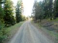
I walked up this road, which is MUCH MUCH better than the road I had just driven.
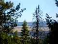
Occasional interesting views through the trees.
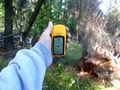
Traditional GPS shot.
The forests are filled with dangers.

But the most dangerous animal....


Achievements
Michael5000 earned the Multihash Achievement
|
- Six attempts and four successes in one long day.