Difference between revisions of "2011-09-22 45 -121"
imported>Michael5000 m (→Achievements) |
imported>FippeBot m (Location) |
||
| (3 intermediate revisions by 3 users not shown) | |||
| Line 34: | Line 34: | ||
== Tracklog == | == Tracklog == | ||
| − | + | A shot in the dark at leaving a tracklog as a csv-txt file didn't work. What form should the link here take ? | |
| − | |||
| − | |||
== Photos == | == Photos == | ||
| Line 58: | Line 56: | ||
[[Category:Expeditions with photos]] | [[Category:Expeditions with photos]] | ||
[[Category:Coordinates reached]] | [[Category:Coordinates reached]] | ||
| + | {{location|US|OR|HO}} | ||
Latest revision as of 00:58, 13 August 2019
| Thu 22 Sep 2011 in 45,-121: 45.6807443, -121.8521663 geohashing.info google osm bing/os kml crox |

Location
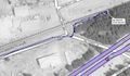
Just off the railroad on the eastern edge of Cascade Locks.
Participants
Plans
I have a hike planed on the Oregon side today, but the Hash looks to be right in Cascade Locks. I think that I'll go on the way.
Expedition
Kydlt
A quick jump into the bushes by the tracks. It wasn't really the empty looking spot that was on the DOQQ. But it was only 20 ft in. I went at about 10 AM & left the marker, but I left the camera in the car. So I stopped on the way back through after a lovely hike up Eagle Creek to Loowit Falls.
Michael5000
It had been literally dozens of hours since I had gone geohashing, and this hashpoint appealed to me for a couple of reasons. For one thing, I think it's funny that it took me almost two years to get to The Dalles, Oregon, and now to hit it three times in nine days. Also, Mrs.5000 had a class for the evening, so why not take a short drive after work, catch a hashpoint, and take another step towards my barmy goal of exercising in all 36 Oregon counties?
Well. I drove out, parked, walked out the railbed and then into the brush, completely failed to notice Kydlt's markers from eight hours earlier -- in retrospect, I should have thought to look for them -- and then ran to the Bridge of the Gods and back, 5.41 miles if you happened to be curious. Not nearly such a nice hike as my colleague got, but Expedition success!! ...and I have now run in Hood River County.
Tracklog
A shot in the dark at leaving a tracklog as a csv-txt file didn't work. What form should the link here take ?
Photos
I was here.
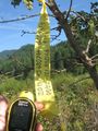
What a terrible photo. It was glarey & I couldn't see what I was doing.
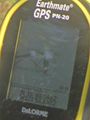
This is a screen capture of my track displayed on the laptop.
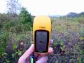
I, too, was here.
- Error creating thumbnail: Unable to save thumbnail to destination
It would be funny if the flags were glaringly obvious in my photo. But they aren't, which makes me feel a little better about not seeing them.


Achievements
For Michael5000
- First Expedition to Hood River County.
- September 2011 now has my most Expeditions (16) and my most successful Expeditions (12) of any month.