Difference between revisions of "2011-10-05 -36 174"
imported>Greenslime m |
imported>FippeBot m (Location) |
||
| (3 intermediate revisions by one other user not shown) | |||
| Line 7: | Line 7: | ||
__NOTOC__ | __NOTOC__ | ||
== Location == | == Location == | ||
| − | Forestry Block, West Auckland, New Zealand | + | Forestry Block, Woodhill, West Auckland, New Zealand |
== Participants == | == Participants == | ||
| Line 14: | Line 14: | ||
== Plans == | == Plans == | ||
| − | These forestry hashes are notorious for their | + | These forestry hashes are notorious for their restricted access points, and probably prickly bushes underneath. I will give it a try anyway, drive there, park up, and probably walk/run some distance on foot. The hash is just off a forestry road. |
== Expedition == | == Expedition == | ||
| − | + | Restal Rd is the main access way into this area, and it turns out, it is a well utilised area of Woodhill forest with MTB park and Tree Adventures confidence course set up, hence, the public actually has ready access to this piece of forest. I didn't know this at the time but basically followed the pre-planned route as far as I could and found this quite offensive signage towards runners (I was planning to run a bit in the forest too.) And of course, fate would have it, the hash point was beyond the signage, literally only about 100 m, and just off the road. | |
| + | |||
| + | Ha, I thought, now is my chance for the Admit One Achievement, so planned to hire a bike and have a bit of a go.....only to find I didn't bring my wallet - I left it with Li'll Homie at home. Disappointment by the bucket-load!! By this stage, having made my way back to the MTB HQ, I explained the whole 'this is random but....' scenario to this Rasta guy with dreads at the counter. He said, 'wooooo thats so coooool man, and sooooo random!' And then said, 'just go ahead ...' so I did...and I got the hash! | ||
| − | |||
| − | |||
== Photos == | == Photos == | ||
| − | |||
| − | |||
| − | |||
<gallery perrow="5"> | <gallery perrow="5"> | ||
| + | File:2011-10-05 -36 174 - No Go Signage.jpg|Offensive signage | ||
| + | File:2011-10-05 -36 174 - GPS Evidence.jpg|My new el-cheapo GPS! Finally up with the times, only to find I am still miles behind! | ||
| + | File:2011-10-05 -36 174 - Hash.jpg|Ready to run, but no, me at the Hash | ||
| + | File:2011-10-05 -36 174 - MTB Tracks.jpg|MTB tracks | ||
| + | |||
</gallery> | </gallery> | ||
== Achievements == | == Achievements == | ||
{{#vardefine:ribbonwidth|800px}} | {{#vardefine:ribbonwidth|800px}} | ||
| − | + | {{Ambassador geohash | |
| − | + | | latitude = -36 | |
| + | | longitude = 174 | ||
| + | | date = 2011-10-05 | ||
| + | | granter = rasta guy at counter | ||
| + | | name = [[User:Greenslime|Greenslime]] | ||
| + | | image = 2011-10-05 -36 174 - No Go Signage.jpg | ||
| + | }} | ||
| − | |||
| − | |||
[[Category:Expeditions]] | [[Category:Expeditions]] | ||
| − | + | [[Category:Expeditions with photos]] | |
| − | [[Category:Expeditions with photos]] | ||
| − | |||
| − | |||
| − | |||
| − | |||
| − | |||
[[Category:Coordinates reached]] | [[Category:Coordinates reached]] | ||
| − | + | {{location|NZ|AUK}} | |
| − | |||
| − | |||
| − | |||
| − | |||
| − | |||
| − | |||
| − | |||
| − | |||
| − | |||
Latest revision as of 01:07, 13 August 2019
| Wed 5 Oct 2011 in -36,174: -36.7410557, 174.4191971 geohashing.info google osm bing/os kml crox |
Location
Forestry Block, Woodhill, West Auckland, New Zealand
Participants
- Greenslime
- Li'll Homie
Plans
These forestry hashes are notorious for their restricted access points, and probably prickly bushes underneath. I will give it a try anyway, drive there, park up, and probably walk/run some distance on foot. The hash is just off a forestry road.
Expedition
Restal Rd is the main access way into this area, and it turns out, it is a well utilised area of Woodhill forest with MTB park and Tree Adventures confidence course set up, hence, the public actually has ready access to this piece of forest. I didn't know this at the time but basically followed the pre-planned route as far as I could and found this quite offensive signage towards runners (I was planning to run a bit in the forest too.) And of course, fate would have it, the hash point was beyond the signage, literally only about 100 m, and just off the road.
Ha, I thought, now is my chance for the Admit One Achievement, so planned to hire a bike and have a bit of a go.....only to find I didn't bring my wallet - I left it with Li'll Homie at home. Disappointment by the bucket-load!! By this stage, having made my way back to the MTB HQ, I explained the whole 'this is random but....' scenario to this Rasta guy with dreads at the counter. He said, 'wooooo thats so coooool man, and sooooo random!' And then said, 'just go ahead ...' so I did...and I got the hash!
Photos
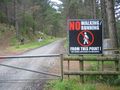
Offensive signage
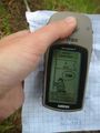
My new el-cheapo GPS! Finally up with the times, only to find I am still miles behind!
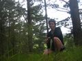
Ready to run, but no, me at the Hash
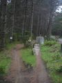
MTB tracks


Achievements
Greenslime earned the Ambassador achievement
|