Difference between revisions of "2011-10-07 43 -87"
imported>RocketMac (→Location) |
imported>FippeBot m (Location) |
||
| (14 intermediate revisions by 2 users not shown) | |||
| Line 1: | Line 1: | ||
| − | |||
| − | |||
| − | |||
| − | |||
| − | |||
| − | |||
| − | |||
| − | |||
| − | |||
{{meetup graticule | {{meetup graticule | ||
| lat=43 | | lat=43 | ||
| Line 14: | Line 5: | ||
}} | }} | ||
| − | |||
== Location == | == Location == | ||
| − | |||
The rear parking lot for [http://www.wisconsinclub.com The Wisconsin Club], a private social and business club in Milwaukee. | The rear parking lot for [http://www.wisconsinclub.com The Wisconsin Club], a private social and business club in Milwaukee. | ||
== Participants == | == Participants == | ||
| − | + | * [[User:RocketMac|RocketMac]] - Adding another graticule to my belt. | |
== Plans == | == Plans == | ||
| − | + | I have a web script that emails me if the day's coordinates are within a specified range of places like my home, work, favorite coffee house and favorite restaurant. This morning's email told me the spot was near the downtown restaurant location. Most of [[43,-87|this graticule]] is in the lake, so I knew this would be one of the few chances I would have to reach a hash in this graticule. | |
| + | |||
| + | The coordinates for the day were in [[43,-87|downtown Milwaukee]] but I live in [[42,-88|Greenfield]] and work in [[43,-88|Pewaukee]] so getting there was going to require finding a way to convince my wife to go out of our way on the night of the last game of the Brewer's NLDS run. | ||
| + | |||
| + | I started formulating a plan... | ||
== Expedition == | == Expedition == | ||
| − | |||
| − | + | By the time I was done with work, the Brewer's game was well underway. I got home in time to watch the last three innings with my wife and celebrate the Brewer's victory! | |
| − | + | ||
| + | Our original dinner plan was to grill hot dogs for the game. With the excitement of the game, we forgot to eat. After the game, we discussed what to do, but I already had a place in mind. The hashpoint was less than a mile from [http://safe-house.com|The Safe House], one of our regular haunts. | ||
| + | |||
| + | I've learned from the past that my wife is more receptive to visiting a geocache if I tell her my intentions '''before''' we go out. After dinner we drove over. The hashpoint was on the line separating two parking spots and both spots were open, so I was hoping she would park in one of those. She didn't like the odd looks we were getting from the valets as we pulled up, so she parked at the edge of the lot instead. | ||
| + | |||
| + | All I had to do was fire up my iPhone's GPS app and walk over pretending to be on the phone. Once I was in the spot, I took a couple of screen captures and took a couple of pictures of myself at the spot with landmarks behind me and went back to the car. | ||
| + | |||
| + | Nice and easy! | ||
== Photos == | == Photos == | ||
| − | |||
| − | |||
| − | |||
<gallery perrow="5"> | <gallery perrow="5"> | ||
| + | Image:2011-10-07 43 -87 04.jpg | The Wisconsin Club is behind me | ||
| + | Image:2011-10-07 43 -87 03.jpg | City hall behind me | ||
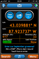
| + | Image:2011-10-07 43 -87 01.png | GPS | ||
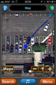
| + | Image:2011-10-07 43 -87 02.png | GPS Map | ||
</gallery> | </gallery> | ||
== Achievements == | == Achievements == | ||
{{#vardefine:ribbonwidth|800px}} | {{#vardefine:ribbonwidth|800px}} | ||
| − | |||
| + | {{land geohash | ||
| + | | latitude = 43 | ||
| + | | longitude = -87 | ||
| + | | date = 2011-10-07 | ||
| + | | name = RocketMac | ||
| + | | image = | ||
| + | }} | ||
| + | {{Easy_geohash | ||
| + | | latitude = 43 | ||
| + | | longitude = -87 | ||
| + | | date = 2011-10-07 | ||
| + | | name = RocketMac | ||
| + | | image = | ||
| + | }} | ||
| + | {{Minesweeper geohash | ||
| + | | graticule = Schaumburg, Illinois | ||
| + | | ranknumber = 3 | ||
| + | | n = true | ||
| + | | ne = true | ||
| + | | e = | ||
| + | | se = | ||
| + | | s = | ||
| + | | sw = | ||
| + | | w = | ||
| + | | nw = true | ||
| + | | name = RocketMac | ||
| + | }} | ||
| − | |||
| − | |||
| − | |||
| − | |||
| − | |||
| − | |||
| − | |||
| − | |||
| − | |||
| − | |||
[[Category:Expeditions]] | [[Category:Expeditions]] | ||
| − | |||
[[Category:Expeditions with photos]] | [[Category:Expeditions with photos]] | ||
| − | |||
| − | |||
| − | |||
| − | |||
| − | |||
[[Category:Coordinates reached]] | [[Category:Coordinates reached]] | ||
| − | + | {{location|US|WI|MU}} | |
| − | |||
| − | |||
| − | |||
| − | |||
| − | |||
| − | |||
| − | |||
| − | |||
| − | |||
Latest revision as of 01:08, 13 August 2019
| Fri 7 Oct 2011 in 43,-87: 43.0398356, -87.9237659 geohashing.info google osm bing/os kml crox |
Location
The rear parking lot for The Wisconsin Club, a private social and business club in Milwaukee.
Participants
- RocketMac - Adding another graticule to my belt.
Plans
I have a web script that emails me if the day's coordinates are within a specified range of places like my home, work, favorite coffee house and favorite restaurant. This morning's email told me the spot was near the downtown restaurant location. Most of this graticule is in the lake, so I knew this would be one of the few chances I would have to reach a hash in this graticule.
The coordinates for the day were in downtown Milwaukee but I live in Greenfield and work in Pewaukee so getting there was going to require finding a way to convince my wife to go out of our way on the night of the last game of the Brewer's NLDS run.
I started formulating a plan...
Expedition
By the time I was done with work, the Brewer's game was well underway. I got home in time to watch the last three innings with my wife and celebrate the Brewer's victory!
Our original dinner plan was to grill hot dogs for the game. With the excitement of the game, we forgot to eat. After the game, we discussed what to do, but I already had a place in mind. The hashpoint was less than a mile from Safe House, one of our regular haunts.
I've learned from the past that my wife is more receptive to visiting a geocache if I tell her my intentions before we go out. After dinner we drove over. The hashpoint was on the line separating two parking spots and both spots were open, so I was hoping she would park in one of those. She didn't like the odd looks we were getting from the valets as we pulled up, so she parked at the edge of the lot instead.
All I had to do was fire up my iPhone's GPS app and walk over pretending to be on the phone. Once I was in the spot, I took a couple of screen captures and took a couple of pictures of myself at the spot with landmarks behind me and went back to the car.
Nice and easy!
Photos

The Wisconsin Club is behind me

City hall behind me
GPS
GPS Map


Achievements
RocketMac earned the Land geohash achievement
|
RocketMac has visited an Easy Geohash
|
RocketMac achieved level 3 of the Minesweeper Geohash achievement
|