Difference between revisions of "2011-10-16 40 -74"
imported>Spindizzy m |
imported>GeorgDerReisende |
||
| Line 1: | Line 1: | ||
| − | |||
| − | |||
| − | |||
| − | |||
| − | |||
| − | |||
| − | |||
| − | |||
| − | |||
{{meetup graticule | {{meetup graticule | ||
| lat=40 | | lat=40 | ||
| Line 74: | Line 65: | ||
}} | }} | ||
| − | + | ||
| − | + | [[Category:Expeditions]] | |
[[Category:Expeditions with photos]] | [[Category:Expeditions with photos]] | ||
[[Category:Coordinates reached]] | [[Category:Coordinates reached]] | ||
Revision as of 20:42, 14 November 2014
| Sun 16 Oct 2011 in 40,-74: 40.5873205, -74.3561470 geohashing.info google osm bing/os kml crox |
Location
Edison, NJ - In the woods behind James Madison Elementary School off New Dover Road - Spindizzy
Participants
Plans
Good news - it's a Sunday and people might not be around to report a stranger with a GPS in one hand and a camera in the other hanging out on an elementary school site. No need to provoke a Police Geohash.
I noticed on Google Earth that there is a paved sidewalk that runs along the woods from the North, starting at the intersection of Heritage Drive and Mickinley Ave. Prudence would suggest parking somewhere near this location and taking advantage of the path. About a 200 meter walk. - Spindizzy 22:40, 15 October 2011 No, I don't know anyone named Prudence...
Expedition
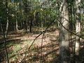
I arrived at the planned destination about 3:30 pm EDT. Good thing I came from the North as mentioned above because as I walked down the path alongside the woods, looking for a way through the brambles (dang, no machete), I spotted a group of students near the edge of the field. I turned back and was able to find a raptor-free way to get into the woods. Getting to the hash point was relatively easy, I just had to avoid prickly brush and large muddy terrain. There were no rocks, nor did I bring tape to post it to a tree, so I put a stick on top of the marker I left on the ground. No doubt someone will discover this 10,000 years from now when the next geohash lands there.
Sorry, no Stupid Grintm photo. This will have to wait until I purchase a smartphone.
Tracklog
Photos
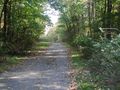
At the start of the path along the woods. Raptor-free access is immediately to the right.
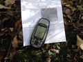
The hash
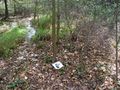
Facing South with the marker
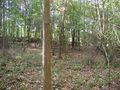
Facing East
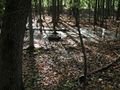
Facing North
Facing West
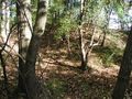
Possible raptor nest?


Achievements
Spindizzy earned the Land geohash achievement
|
