Difference between revisions of "2011-10-16 48 9"
imported>Steingesicht (→Gallery) |
imported>FippeBot m (Location) |
||
| (4 intermediate revisions by one other user not shown) | |||
| Line 14: | Line 14: | ||
== Expedition == | == Expedition == | ||
| − | + | When I found that the sunday hash is not far from home, I planned to go there during our sunday-afternoon walk. | |
| + | We successfully completed the very nice multi-cache [http://coord.info/GC19GRY Krimi: Es geschah am helllichten Tag]. After that I made a detour to the geohash. | ||
| + | The hash itself is situated at a cemetery and it is accessible on a public footpath. I like to walk on cemeteries. I love the silence and I love the thought, that somedays our descendants will remember us after a fullfilled life. | ||
| + | I made I little walk around the cemetery, took a picture at the hashpoint ''(could not reach the point exactly, scince I had to step on the green to do that - but from my point of view, the hashpoint was reached)'' | ||
| + | On may way back I passed by some childrens graves - sometimes, life is not fair, so I left the cemetery a little sad and reflective. | ||
== Gallery == | == Gallery == | ||
<gallery> | <gallery> | ||
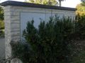
| − | + | File:2011_10_16_48_9_Entrance_to_cemetery.jpeg | The Entrance to the cemetery and a sign with the rules for this place | |
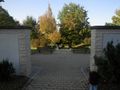
| + | File:2011_10_16_48_9_At_the_cementery.jpeg | a view at the walk | ||
| + | File:2011_10_16_48_9_View_from_hashpoint.jpeg | I saw a hot-air balloon while standing at the hash. | ||
| + | File:2011_10_16_48_9_Nearest_to_hashpoint.jpeg | nearest point to hashpoint, I could reach without stepping on the green | ||
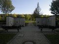
| + | File:2011_10_16_48_9_Hashpoint.jpeg | Probaly the hashpoint | ||
| + | File:2011_10_16_48_9_Downhill_view.jpeg | View from hashpoint | ||
| + | File:2011_10_16_48_9_Uphill_view_to_hashpoint.jpeg | uphill view to hashpoint | ||
</gallery> | </gallery> | ||
| + | == Achievements == | ||
| + | {{holy hash | latitude = 48 | longitude = 9 | date = 2011-10-16 | name = Steingesicht}} | ||
| − | + | [[Category:Expeditions]] | |
[[Category:Coordinates reached]] | [[Category:Coordinates reached]] | ||
[[Category:Expeditions with photos]] | [[Category:Expeditions with photos]] | ||
<!--[[Category:Coordinates not reached]]--> | <!--[[Category:Coordinates not reached]]--> | ||
| + | {{location|DE|BW|ES}} | ||
Latest revision as of 01:15, 13 August 2019
| Sun 16 Oct 2011 in 48,9: 48.5873205, 9.3561470 geohashing.info google osm bing/os kml crox |
Location
A cemetery in Frickenhausen, near Nürtingen.
Participants
Steingesicht was there after a geocaching tour.
Expedition
When I found that the sunday hash is not far from home, I planned to go there during our sunday-afternoon walk. We successfully completed the very nice multi-cache Krimi: Es geschah am helllichten Tag. After that I made a detour to the geohash. The hash itself is situated at a cemetery and it is accessible on a public footpath. I like to walk on cemeteries. I love the silence and I love the thought, that somedays our descendants will remember us after a fullfilled life. I made I little walk around the cemetery, took a picture at the hashpoint (could not reach the point exactly, scince I had to step on the green to do that - but from my point of view, the hashpoint was reached) On may way back I passed by some childrens graves - sometimes, life is not fair, so I left the cemetery a little sad and reflective.
Gallery
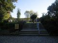
The Entrance to the cemetery and a sign with the rules for this place
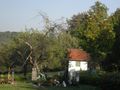
a view at the walk
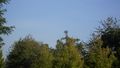
I saw a hot-air balloon while standing at the hash.
nearest point to hashpoint, I could reach without stepping on the green
Probaly the hashpoint
View from hashpoint
uphill view to hashpoint


Achievements
Steingesicht earned the Holy hash achievement
|