Difference between revisions of "2011-11-12 41 -88"
imported>EvilUncleNomo ([live] In a field near Big Rock, Illinois, U.S.A.) |
imported>FippeBot m (Location) |
||
| (12 intermediate revisions by 2 users not shown) | |||
| Line 1: | Line 1: | ||
| − | |||
| − | |||
| − | |||
| − | |||
| − | |||
| − | |||
| − | |||
| − | |||
| − | |||
| − | |||
{{meetup graticule | {{meetup graticule | ||
| lat=41 | | lat=41 | ||
| Line 15: | Line 5: | ||
}} | }} | ||
| − | |||
__NOTOC__ | __NOTOC__ | ||
== Location == | == Location == | ||
| − | + | In a corn field near Big Rock, Illinois, U.S.A. Well, actually it might has been closer to Sugar Grove. | |
== Participants == | == Participants == | ||
| − | + | * [[User:EvilUncleNomo|EvilUncleNomo]] and [[User:The Wife|The Wife]] | |
== Plans == | == Plans == | ||
| − | + | *[[User:EvilUncleNomo|EvilUncleNomo]] and [[User:The Wife|The Wife]] are planning on attempting this geohash Saturday afternoon. | |
== Expedition == | == Expedition == | ||
| − | + | This time the target was in a corn field adjacent to what looked like a country club. [[User:The Wife|The Wife]] suggested that walking along the property line might be easier than trudging through the corn. We saw no signs or people to tell us we didn't belong there, so we forged ahead. Along the way we saw a deer, but I was too slow with the camera to take its picture. | |
| + | == Photos == | ||
| + | <gallery perrow="5"> | ||
| − | + | Image:2011-11-12_41_-88_15-47-44-542.jpg | It's in there somewhere. [http://www.openstreetmap.org/?lat=41.75002583333333&lon=-88.48918098333333&zoom=16&layers=B000FTF @41.7500,-88.4892] | |
| − | == | ||
| − | |||
| − | == | + | Image:2011-11-12_41_-88_16-02-18-013.jpg | Past the golf course ... [http://www.openstreetmap.org/?lat=41.74883403333333&lon=-88.49379615&zoom=16&layers=B000FTF @41.7488,-88.4938] |
| − | + | ||
| − | Image: | + | Image:2011-11-12_41_-88_16-06-59-447.jpg | Deer tracks! [http://www.openstreetmap.org/?lat=41.74826768333333&lon=-88.49358491666666&zoom=16&layers=B000FTF @41.7483,-88.4936] |
| − | -- | + | |
| − | + | Image:2011-11-12_41_-88_16-13-53-092.jpg | Child of the corn. [http://www.openstreetmap.org/?lat=41.748101733333336&lon=-88.4934656&zoom=16&layers=B000FTF @41.7481,-88.4935] | |
| − | |||
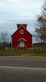
| − | + | Image:2011-11-12_41_-88_17-36-39-864.jpg | A church under construction across the street from the target. | |
| − | |||
| − | |||
| + | Image:2011-11-12_41_-88_17-35-29-729.jpg | Air Classics Museum of Aviation at Aurora Municipal Airport. | ||
| − | + | Image:2011-11-12_41_-88_17-37-31-928.jpg | Not sure exactly what this is, but it looked interesting so I took a picture of it. | |
| − | |||
| − | |||
| − | < | + | </gallery> |
| − | |||
| − | |||
| − | |||
| − | |||
[[Category:Expeditions]] | [[Category:Expeditions]] | ||
| − | |||
[[Category:Expeditions with photos]] | [[Category:Expeditions with photos]] | ||
| − | |||
| − | |||
| − | |||
| − | |||
| − | |||
[[Category:Coordinates reached]] | [[Category:Coordinates reached]] | ||
| − | + | {{location|US|IL|KE}} | |
| − | |||
| − | |||
| − | |||
| − | |||
| − | |||
| − | |||
| − | |||
| − | |||
| − | |||
Latest revision as of 01:30, 13 August 2019
| Sat 12 Nov 2011 in 41,-88: 41.7481019, -88.4934818 geohashing.info google osm bing/os kml crox |
Location
In a corn field near Big Rock, Illinois, U.S.A. Well, actually it might has been closer to Sugar Grove.
Participants
Plans
- EvilUncleNomo and The Wife are planning on attempting this geohash Saturday afternoon.
Expedition
This time the target was in a corn field adjacent to what looked like a country club. The Wife suggested that walking along the property line might be easier than trudging through the corn. We saw no signs or people to tell us we didn't belong there, so we forged ahead. Along the way we saw a deer, but I was too slow with the camera to take its picture.
Photos
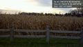
It's in there somewhere. @41.7500,-88.4892
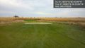
Past the golf course ... @41.7488,-88.4938
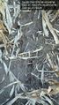
Deer tracks! @41.7483,-88.4936

Child of the corn. @41.7481,-88.4935
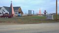
A church under construction across the street from the target.
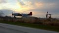
Air Classics Museum of Aviation at Aurora Municipal Airport.
Not sure exactly what this is, but it looked interesting so I took a picture of it.


