Difference between revisions of "2011-11-26 39 -108"
imported>Michael5000 m (→Plans) |
Michael5000 (talk | contribs) (→Tracklog) |
||
| (8 intermediate revisions by 2 users not shown) | |||
| Line 18: | Line 18: | ||
__NOTOC__ | __NOTOC__ | ||
== Location == | == Location == | ||
| − | + | ||
| + | In rugged land west of Highway 139. | ||
== Participants == | == Participants == | ||
| Line 30: | Line 31: | ||
== Expedition == | == Expedition == | ||
| − | |||
| − | + | From base camp in Grand Junction, we took a borrowed four-wheel drive Expedition Vehicle up the highway. Mitchell Road was distinctly unimproved but perfectly driveable. A track visible on satellite imagery was also no problem, but when we reached an arroyo with a rough patch about a mile out from the hashpoint, we decided to go light on the borrowed car and walk in. We encountered a truck that could only be other geohashers, but turned out to be duck hunters. The track led us to within 150 feet of the hashpoint, and it was an easy walk through light sage to ground zero. For lack of a better monument, we left a pencil stuck in the ground as a nod to all of the many other geohashers who will no doubt pour out in the afternoon. | |
| − | + | ||
| + | Expedition Success! | ||
== Photos == | == Photos == | ||
| − | + | ||
| − | |||
| − | |||
<gallery perrow="5"> | <gallery perrow="5"> | ||
| + | File:2011-11-26 39 -108 0.JPG|A borrowed G.E.V. | ||
| + | File:2011-11-26 39 -108 1.JPG|Mitchell Road | ||
| + | File:2011-11-26 39 -108 2.JPG|The track running southeast from Mitchell Road | ||
| + | File:2011-11-26 39 -108 3.JPG|Not a slope you want to drive a borrowed car down, and a good excuse for a hike | ||
| + | File:2011-11-26 39 -108 4.JPG|The Bear at the hashpoint | ||
| + | File:2011-11-26 39 -108 5.JPG|Winter sun on Oregonians | ||
| + | File:2011-11-26 39 -108 6.JPG|The lay of the land | ||
| + | File:2011-11-26 39 -108 7.JPG|The "Book Cliffs" to the north | ||
| + | File:2011-11-26 39 -108 8.JPG|Fenceline and telephone poles | ||
| + | |||
</gallery> | </gallery> | ||
== Achievements == | == Achievements == | ||
{{#vardefine:ribbonwidth|800px}} | {{#vardefine:ribbonwidth|800px}} | ||
| − | |||
| + | *New State for Michael5000 and Mrs.5000. | ||
| + | *Southernmost, Easternmost, and probably Highest Expedition for Michael5000 and Mrs.5000. | ||
| + | *Expedition #99 for Michael5000. | ||
| − | |||
| − | |||
| − | |||
| − | |||
| − | |||
| − | |||
| − | |||
| − | |||
| − | |||
| − | |||
[[Category:Expeditions]] | [[Category:Expeditions]] | ||
| − | |||
[[Category:Expeditions with photos]] | [[Category:Expeditions with photos]] | ||
| − | |||
| − | |||
| − | |||
| − | |||
[[Category:Coordinates reached]] | [[Category:Coordinates reached]] | ||
| − | + | {{location|US|CO|ME}} | |
| − | |||
| − | |||
| − | |||
| − | |||
| − | |||
| − | |||
| − | |||
| − | |||
| − | |||
Latest revision as of 07:32, 12 February 2022
| Sat 26 Nov 2011 in 39,-108: 39.3244698, -108.8723498 geohashing.info google osm bing/os kml crox |
Location
In rugged land west of Highway 139.
Participants
Plans
We are going to head out Mitchell Road sometime in the late morning, and see if this is doable or not.
Expedition
From base camp in Grand Junction, we took a borrowed four-wheel drive Expedition Vehicle up the highway. Mitchell Road was distinctly unimproved but perfectly driveable. A track visible on satellite imagery was also no problem, but when we reached an arroyo with a rough patch about a mile out from the hashpoint, we decided to go light on the borrowed car and walk in. We encountered a truck that could only be other geohashers, but turned out to be duck hunters. The track led us to within 150 feet of the hashpoint, and it was an easy walk through light sage to ground zero. For lack of a better monument, we left a pencil stuck in the ground as a nod to all of the many other geohashers who will no doubt pour out in the afternoon.
Expedition Success!
Photos
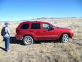
A borrowed G.E.V.
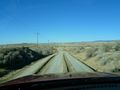
Mitchell Road
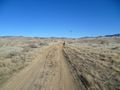
The track running southeast from Mitchell Road
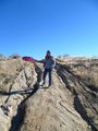
Not a slope you want to drive a borrowed car down, and a good excuse for a hike
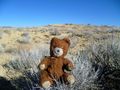
The Bear at the hashpoint
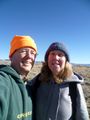
Winter sun on Oregonians
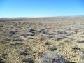
The lay of the land
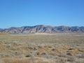
The "Book Cliffs" to the north
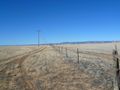
Fenceline and telephone poles


Achievements
- New State for Michael5000 and Mrs.5000.
- Southernmost, Easternmost, and probably Highest Expedition for Michael5000 and Mrs.5000.
- Expedition #99 for Michael5000.