Difference between revisions of "2011-11-30 global"
imported>Per S |
imported>Fippe |
||
| (23 intermediate revisions by 3 users not shown) | |||
| Line 1: | Line 1: | ||
| − | + | {| width="100%" border=0 cellpadding=0 cellspacing=0 style="border: 0; border-collapse: collapse; border-spacing: 0; margin: 0; padding: 0" | |
| − | + | | align="left" valign="top" style="padding: 0.5em 1em 0.5em 0" | [[Image:2011-11-30 global 5 The Geohashers.jpg|467px]] | |
| − | | | + | |
| − | | | + | | align="right" valign="top" | <table class="infobox" cellspacing="5" style="width: 22em; text-align: left; font-size: 88%; line-height: 1.5em; border: 1px solid #aaa; background-color: #f9f9f9; color: black; margin: 0.5em 0 0.5em 1em; padding: 0.2em; float: right; clear: right;"> |
| − | + | <tr> | |
| − | | | + | <td colspan="3" style="text-align: center;"> |
| − | + | [[Image:2011-11-30 global 0 Globalhash.jpg|link=]]</td> | |
| − | + | </tr> | |
| + | |||
| + | <tr> | ||
| + | <td colspan="3" style="text-align:center;"> | ||
| + | <p>Globalhash on [[2011-11-30|Wed 30 Nov 2011]]:<br /> | ||
| + | <b>60.560082, 17.383212</b><br /></p> | ||
| + | <p>[http://maps.google.com/maps?f=q&hl=en&q=60.560082,+17.383212+(Globalhash+for+30+Nov+2011)&ie=UTF8&t=h google] [http://www.openstreetmap.org/?mlat=60.5600828&mlon=17.383212&zoom=16&layers=B000FTF osm]</p></td> | ||
| + | </tr> | ||
| + | </table> | ||
| + | |||
| + | |} | ||
__NOTOC__ | __NOTOC__ | ||
| Line 20: | Line 30: | ||
== Plans == | == Plans == | ||
| − | Well, this was pretty spontaneous, but the plan was to fetch a | + | Well, this was pretty spontaneous, but the plan was to fetch a C30 from the car sharing, like I usually do, and drive there after work. |
== Expedition == | == Expedition == | ||
| − | <! | + | |
| + | ==== Nov 29, 2011 5:44 PM ==== | ||
| + | I get a message on my User talk page from [[User:Ekorren|Ekorren]] saying | ||
| + | <blockquote> | ||
| + | Hej :)<br> | ||
| + | <br> | ||
| + | You got one of those "once in a lifetime" chances to score a globalhash ;) Go get it at Älvkarleby! | ||
| + | </blockquote> | ||
| + | I don't even know what a User talk page is, but I get an email telling me about the update, so I read the message the same night. I decide I will probably go for it, even though it's 100 miles away. | ||
| + | |||
| + | ==== Nov 30, 2011 ==== | ||
| + | At work, I tell my colleagues about geohashing and the globalhash and Caroline says her eleven year old son Gabriel would have loved an adventure like that. | ||
| + | |||
| + | ==== Nov 30, 2011 2:58 PM ==== | ||
| + | The sun sets in Stockholm. | ||
| + | |||
| + | ==== Nov 30, 2011 6:03 PM ==== | ||
| + | I leave work. I stop on the way to buy a flashlight. I get a fat Maglite. | ||
| + | |||
| + | ==== Nov 30, 2011 6:12 PM ==== | ||
| + | Gabriel calls and says he wants to come and that his mom says it's OK. I talk to his mom and tell her I'm not even at the car yet and that we won't be back before midnight. She's not happy, but she can't back down now that she got her sons' hopes up. She tells me that she will also come along and to hurry up. | ||
| + | |||
| + | ==== Nov 30, 2011 7:29 PM ==== | ||
| + | I start recording a track in My Tracks on my phone and start the trip in today's [[Citation Needed|citation]]. | ||
| + | |||
| + | ==== Nov 30, 2011 7:58 PM ==== | ||
| + | I pick up Gabriel and Caroline. They have made sandwiches and bring a camera and their own flashlights. | ||
| + | |||
| + | ==== Nov 30, 2011 9:31 PM ==== | ||
| + | We arrive close to the hash point and park the car. The hashpoint is about 1000 ft from the road. Now I'm really happy that I'm not alone. The forest is very dark. | ||
| + | |||
| + | ==== Nov 30, 2011 10:00 PM ==== | ||
| + | We reach the hashpoint. We put up a marker on a tree and take a few pictures. I get a screenshot of my phone showing Google Maps, but forget it's not showing the coordinates. Luckily i have My Tracks recording my track. | ||
| + | |||
| + | ==== Nov 30, 2011 10:48 PM ==== | ||
| + | After having some sandwiches an blueberry juice and watching an amazing star sky, we head back. | ||
| + | |||
| + | ==== Dec 1, 2011 0:16 AM ==== | ||
| + | I drop off Gabriel and Caroline at their place. | ||
| + | |||
| + | ==== Dec 1, 2011 1:03 AM ==== | ||
| + | I'm back where I started and park the car. The track log says the total distance is 227 miles. | ||
== Tracklog == | == Tracklog == | ||
| − | + | I hosted the [http://sites.google.com/site/perstracklogs/home/Globalhash2011-11-30.kmz tracklog] on Google Sites. | |
== Photos == | == Photos == | ||
| − | < | + | <gallery widths=117px perrow="5"> |
| − | Image: | + | Image:2011-11-30 global 1 The Location.jpg | The location |
| − | -- | + | Image:2011-11-30 global 2 The Navigator.jpg | The navigator |
| − | + | Image:2011-11-30 global 3 Putting up the Marker.jpg | Putting up the marker | |
| + | Image:2011-11-30 global 4 Marker.jpg | Marker | ||
| + | Image:2011-11-30 global 5 The Geohashers.jpg | The geohashers | ||
| + | Image:2011-11-30 global 6 Tracklog Visualization.jpg | Tracklog visualization | ||
| + | Image:2011-11-30_global_7_Google_Maps_Screenshot.jpg | Google Maps screenshot | ||
</gallery> | </gallery> | ||
== Achievements == | == Achievements == | ||
| − | {{ | + | {{globalhash |
| − | + | | date = 2011-11-30 | |
| − | + | | name = [[User:Per S|Per S]] | |
| − | + | | image = 2011-11-30 global 5 The Geohashers.jpg | |
| − | + | }} | |
| − | |||
| − | [[ | ||
| − | |||
| − | |||
| − | |||
| − | |||
| − | |||
| − | |||
| − | |||
| − | |||
| − | |||
| − | |||
| − | |||
| − | |||
| − | |||
| − | |||
| − | |||
| − | |||
| − | |||
| − | + | [[Category: Meetup on 2011-11-30]] | |
| − | [[Category: | + | [[Category: Globalhash]] |
| − | + | [[Category:Meetup in 60 17]] | |
| − | [[Category: | + | [[Category: Expeditions]] |
| − | [[Category: | + | [[Category: Expeditions with photos]] |
| − | [[Category: | + | [[Category: Coordinates reached]] |
| − | [[Category: | + | {{location|SE|C}} |
| − | |||
Latest revision as of 18:19, 8 August 2019

|
| ||||||
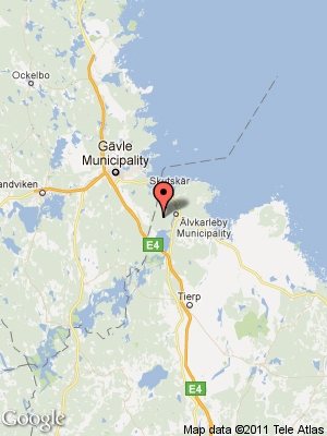
Location
In the woods outside of Älvkarleby, Sweden.
Participants
- Per S
- Gabriel
- Caroline
Plans
Well, this was pretty spontaneous, but the plan was to fetch a C30 from the car sharing, like I usually do, and drive there after work.
Expedition
Nov 29, 2011 5:44 PM
I get a message on my User talk page from Ekorren saying
Hej :)
You got one of those "once in a lifetime" chances to score a globalhash ;) Go get it at Älvkarleby!
I don't even know what a User talk page is, but I get an email telling me about the update, so I read the message the same night. I decide I will probably go for it, even though it's 100 miles away.
Nov 30, 2011
At work, I tell my colleagues about geohashing and the globalhash and Caroline says her eleven year old son Gabriel would have loved an adventure like that.
Nov 30, 2011 2:58 PM
The sun sets in Stockholm.
Nov 30, 2011 6:03 PM
I leave work. I stop on the way to buy a flashlight. I get a fat Maglite.
Nov 30, 2011 6:12 PM
Gabriel calls and says he wants to come and that his mom says it's OK. I talk to his mom and tell her I'm not even at the car yet and that we won't be back before midnight. She's not happy, but she can't back down now that she got her sons' hopes up. She tells me that she will also come along and to hurry up.
Nov 30, 2011 7:29 PM
I start recording a track in My Tracks on my phone and start the trip in today's citation.
Nov 30, 2011 7:58 PM
I pick up Gabriel and Caroline. They have made sandwiches and bring a camera and their own flashlights.
Nov 30, 2011 9:31 PM
We arrive close to the hash point and park the car. The hashpoint is about 1000 ft from the road. Now I'm really happy that I'm not alone. The forest is very dark.
Nov 30, 2011 10:00 PM
We reach the hashpoint. We put up a marker on a tree and take a few pictures. I get a screenshot of my phone showing Google Maps, but forget it's not showing the coordinates. Luckily i have My Tracks recording my track.
Nov 30, 2011 10:48 PM
After having some sandwiches an blueberry juice and watching an amazing star sky, we head back.
Dec 1, 2011 0:16 AM
I drop off Gabriel and Caroline at their place.
Dec 1, 2011 1:03 AM
I'm back where I started and park the car. The track log says the total distance is 227 miles.
Tracklog
I hosted the tracklog on Google Sites.
Photos
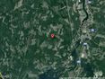
The location
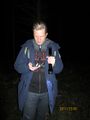
The navigator
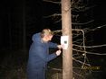
Putting up the marker
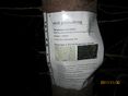
Marker
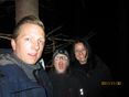
The geohashers
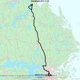
Tracklog visualization
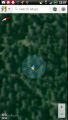
Google Maps screenshot


Achievements
Per S earned the Globalhash achievement
|