Difference between revisions of "2011-12-08 -37 145"
imported>Stevage (Created page with "{{subst:Expedition |lat = -37 |lon = 145 |date = 2011-12-08 }}") |
m (More specific location) |
||
| (4 intermediate revisions by 2 users not shown) | |||
| Line 1: | Line 1: | ||
| + | [[File:-37 145 2011-12-08d.jpg|thumb|left]] | ||
| − | |||
| − | |||
| − | |||
| − | |||
| − | |||
| − | |||
| − | |||
| − | |||
| − | |||
{{meetup graticule | {{meetup graticule | ||
| lat=-37 | | lat=-37 | ||
| Line 15: | Line 7: | ||
}} | }} | ||
| − | |||
__NOTOC__ | __NOTOC__ | ||
== Location == | == Location == | ||
| − | + | On a footpath/cycling path in Shepherd's Bush, a park in the eastern suburbs of Melbourne. | |
== Participants == | == Participants == | ||
| − | + | Just [[User:Stevage|Stevage]]. Aww. tAlex cbf. | |
| + | |||
| + | == Expedition == | ||
| + | As usually happens, I was alerted to the hash by [[User:Felix Dance|Felix Dance]]. A fantastic location, in a nice park, about 13km from my house. Shepherd's Bush is one of a series of parks along the Dandenong Creek, a boundary that for a long time marked the de facto eastern border of Melbourne. You can see it in this 1966 Melway: http://melwayed1.melway.com.au/071.jpg (the hash is right on the red text that says "Shire of Knox"). | ||
| − | + | My parents live nearby, so I'm somewhat familiar with the area. I've walked within 2m or so of the hash before. | |
| − | |||
| − | == | + | Anyway, I was going to ride there after work. But work was followed by work drinks. In the end, I drove, mostly because I wanted to see the hash in daylight. I couldn't find my camera, so had to use the GPS one. |
| − | + | ||
| + | I drove. I walked 200 metres down a lovely path, listening to the frogs, the cockatoos, and walking through a few spiders webs. As I got closer, it looked like the point might be in some wetlands, or at least require some gnarly bushbashing. No such luck. Disappointingly, it was really right next to the path. | ||
| + | |||
| + | === Déjà vu ! === | ||
| + | Remarkably, it turns out that I have proof of having visited the hash before - with one slight hitch. I walked down that path just after Christmas 2009, recording a trace for OpenStreetMap. Sadly, that was about the only time ever that the GPS was misbehaving, so there's a section (yes, *that section*) where it's actually off by some tens of metres. Oh well. http://www.gpsies.com/map.do?fileId=kpmpdxazijzcxiyf | ||
== Tracklog == | == Tracklog == | ||
| − | + | http://www.gpsies.com/map.do?fileId=ekxzuiizhghkjjvh | |
== Photos == | == Photos == | ||
| − | |||
| − | |||
| − | |||
<gallery perrow="5"> | <gallery perrow="5"> | ||
| + | File:-37 145 2011-12-08a.jpg | ||
| + | File:-37 145 2011-12-08b.jpg | ||
| + | File:-37 145 2011-12-08c.jpg | ||
| + | File:-37 145 2011-12-08d.jpg | ||
| + | File:-37 145 2011-12-08e.jpg | Frog eggs? They were quite high off the ground. | ||
</gallery> | </gallery> | ||
== Achievements == | == Achievements == | ||
{{#vardefine:ribbonwidth|800px}} | {{#vardefine:ribbonwidth|800px}} | ||
| − | + | {{Déjà vu geohash|latitude=-37|longitude=145|date=2011-12-08|olddate=2009-12-27}} | |
| − | |||
| − | |||
| − | |||
| − | |||
| − | |||
| − | |||
| − | |||
| − | |||
| − | |||
| − | |||
[[Category:Expeditions]] | [[Category:Expeditions]] | ||
| − | |||
[[Category:Expeditions with photos]] | [[Category:Expeditions with photos]] | ||
| − | |||
| − | |||
| − | |||
| − | |||
[[Category:Coordinates reached]] | [[Category:Coordinates reached]] | ||
| − | + | {{location|AU|VIC|KN}} | |
| − | |||
| − | |||
| − | |||
| − | |||
| − | |||
| − | |||
| − | |||
| − | |||
| − | |||
Latest revision as of 12:08, 1 August 2020

| Thu 8 Dec 2011 in -37,145: -37.8795012, 145.1922587 geohashing.info google osm bing/os kml crox |
Location
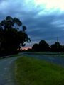
On a footpath/cycling path in Shepherd's Bush, a park in the eastern suburbs of Melbourne.
Participants
Just Stevage. Aww. tAlex cbf.
Expedition
As usually happens, I was alerted to the hash by Felix Dance. A fantastic location, in a nice park, about 13km from my house. Shepherd's Bush is one of a series of parks along the Dandenong Creek, a boundary that for a long time marked the de facto eastern border of Melbourne. You can see it in this 1966 Melway: http://melwayed1.melway.com.au/071.jpg (the hash is right on the red text that says "Shire of Knox").
My parents live nearby, so I'm somewhat familiar with the area. I've walked within 2m or so of the hash before.
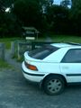
Anyway, I was going to ride there after work. But work was followed by work drinks. In the end, I drove, mostly because I wanted to see the hash in daylight. I couldn't find my camera, so had to use the GPS one.
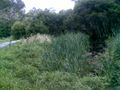
I drove. I walked 200 metres down a lovely path, listening to the frogs, the cockatoos, and walking through a few spiders webs. As I got closer, it looked like the point might be in some wetlands, or at least require some gnarly bushbashing. No such luck. Disappointingly, it was really right next to the path.
Déjà vu !
Remarkably, it turns out that I have proof of having visited the hash before - with one slight hitch. I walked down that path just after Christmas 2009, recording a trace for OpenStreetMap. Sadly, that was about the only time ever that the GPS was misbehaving, so there's a section (yes, *that section*) where it's actually off by some tens of metres. Oh well. http://www.gpsies.com/map.do?fileId=kpmpdxazijzcxiyf
Tracklog
http://www.gpsies.com/map.do?fileId=ekxzuiizhghkjjvh
Photos

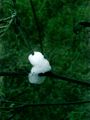
Frog eggs? They were quite high off the ground.


Achievements
This user earned the Déjà Vu Geohash Achievement
|