Difference between revisions of "2011-12-19 42 -88"
imported>RocketMac (→Tracklog) |
m (→Tracklog: chilly hedgehog) |
||
| (8 intermediate revisions by 3 users not shown) | |||
| Line 1: | Line 1: | ||
| − | |||
| − | |||
| − | |||
| − | |||
| − | |||
| − | |||
| − | |||
| − | |||
| − | |||
{{meetup graticule | {{meetup graticule | ||
| lat=42 | | lat=42 | ||
| lon=-88 | | lon=-88 | ||
| date=2011-12-19 | | date=2011-12-19 | ||
| + | | map=<map lat="42" lon="-88" date="2011-12-19" /> | ||
}} | }} | ||
| Line 34: | Line 26: | ||
== Expedition == | == Expedition == | ||
<!-- how it all turned out. your narrative goes here. --> | <!-- how it all turned out. your narrative goes here. --> | ||
| + | |||
| + | Not much to it, really. I left work and started my GPS tracklog. From there, I just drove the route I had already picked out and navigated evening rush hour traffic. | ||
| + | |||
| + | Pulling into the area, I pulled over to take the [[Category:Grins|Stupid Grin(tm)]] photo and verify location. Since it was dark, I took a picture of the hashpoint in my headlights. (is that a song?) | ||
| + | |||
| + | From there, I went home. Easy peasy! | ||
| + | |||
| + | '''Note:''' as of this writing, the coordinate calculators are still offline. Based on my own checks, I think Yahoo! changed their HTML which is throwing off the parsers. | ||
| + | |||
| + | [[User:RocketMac|RocketMac]] 23:18, 19 December 2011 (EST) | ||
| + | |||
| + | == Trust But Verify == | ||
| + | |||
| + | This morning the dot appears on the map, but the coordinates still show wrong. Discussion on the page verified my numbers, but the auto-generated math is still wrong. Luckily, [http://activegeohasher.com/geohash/2011-12-19/42/-88 Active Geohasher] agrees with me. | ||
| + | |||
| + | [[User:RocketMac|RocketMac]] 12:51, 20 December 2011 (EST) | ||
== Tracklog == | == Tracklog == | ||
| − | + | {{tracklog|2011-12-19 42 -88.gpx}} | |
My log is available in [http://coldshadow.com/geohashing/2011-12-19.gpx GPX] and [http://coldshadow.com/geohashing/2011-12-19.kmz KMZ] formats | My log is available in [http://coldshadow.com/geohashing/2011-12-19.gpx GPX] and [http://coldshadow.com/geohashing/2011-12-19.kmz KMZ] formats | ||
| Line 53: | Line 61: | ||
{{#vardefine:ribbonwidth|800px}} | {{#vardefine:ribbonwidth|800px}} | ||
<!-- Add any achievement ribbons you earned below, or remove this section --> | <!-- Add any achievement ribbons you earned below, or remove this section --> | ||
| + | {{land geohash | ||
| + | | latitude = 42 | ||
| + | | longitude = -88 | ||
| + | | date = 2011-12-19 | ||
| + | | name = RocketMac | ||
| + | | image = | ||
| + | }} | ||
| + | {{Easy_geohash | ||
| + | | latitude = 42 | ||
| + | | longitude = -88 | ||
| + | | date = 2011-12-19 | ||
| + | | name = RocketMac | ||
| + | | image = | ||
| + | }} | ||
| + | <!-- | ||
| + | {{Blinded by Science | ||
| + | | latitude = 42 | ||
| + | | longitude = -88 | ||
| + | | date = 2011-12-19 | ||
| + | | reason = because the coordinate calculators were offline | ||
| + | | name = RocketMac | ||
| + | | image = | ||
| + | }} | ||
| + | --> | ||
| + | {{gratuitous ribbon | ||
| + | | color = #0000ff | ||
| + | | icon = ShowYourWork.png | ||
| + | | latitude = 42 | ||
| + | | longitude = -88 | ||
| + | | date = 2011-12-19 | ||
| + | | achievement = Teacher's Pet Award | ||
| + | | description = showing his work to calculate the | ||
| + | | name = RocketMac | ||
| + | | image = | ||
| + | }} | ||
| − | |||
| − | |||
| − | |||
| − | |||
| − | |||
| − | |||
| − | |||
| − | |||
| − | |||
| − | |||
[[Category:Expeditions]] | [[Category:Expeditions]] | ||
| − | |||
[[Category:Expeditions with photos]] | [[Category:Expeditions with photos]] | ||
| − | + | ||
| − | |||
| − | |||
| − | |||
| − | |||
[[Category:Coordinates reached]] | [[Category:Coordinates reached]] | ||
| − | + | {{location|US|WI|WK}} | |
| − | |||
| − | |||
| − | |||
| − | |||
| − | |||
| − | |||
| − | |||
| − | |||
| − | |||
Latest revision as of 05:54, 19 September 2020
| Mon 19 Dec 2011 in 42,-88: 42.9655473, -88.1117935 geohashing.info google osm bing/os kml crox |
Contents
Location
The middle of Delphine Dr. in New Berlin, WI
Participants
Plans
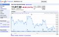
When I checked my iPhone app this morning, the data seemed to come up slow but valid. When I checked peeron and one or two of the other calculators, there was no valid data for the day. I've been playing with these numbers manually recently, so what the heck! I grabbed the opening value from Yahoo! and played with my worksheet program to get the values. Since it's close to Christmas, I decided to check the list twice.
I spent some time during lunch on Google Maps to find a route from work to home that would pass through the coordinates without having to stop or cross my own GPS trail.
If this works out, I'll finally earn the Tron achievement for sure! ...and then I read that I have to return to the same spot! *sigh*
RocketMac 15:18, 19 December 2011 (EST)
Expedition
Not much to it, really. I left work and started my GPS tracklog. From there, I just drove the route I had already picked out and navigated evening rush hour traffic.
Pulling into the area, I pulled over to take the photo and verify location. Since it was dark, I took a picture of the hashpoint in my headlights. (is that a song?)
From there, I went home. Easy peasy!
Note: as of this writing, the coordinate calculators are still offline. Based on my own checks, I think Yahoo! changed their HTML which is throwing off the parsers.
RocketMac 23:18, 19 December 2011 (EST)
Trust But Verify
This morning the dot appears on the map, but the coordinates still show wrong. Discussion on the page verified my numbers, but the auto-generated math is still wrong. Luckily, Active Geohasher agrees with me.
RocketMac 12:51, 20 December 2011 (EST)
Tracklog
My log is available in GPX and KMZ formats
Photos
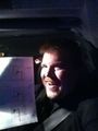
Stupid Grin
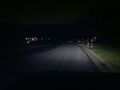
The hashpoint in the headlights
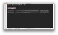
Showing my work
Numbers don't lie


Achievements
RocketMac earned the Land geohash achievement
|
RocketMac has visited an Easy Geohash
|
RocketMac earned the Teacher's Pet Award
|