Difference between revisions of "2012-01-10 45 -122"
imported>Jiml m (Typo and Link fixes) |
imported>Jiml m (Adjust result code and typo fix) |
||
| Line 55: | Line 55: | ||
Image:2012-01-10-45 -122 10 then up this hill.jpg|And went up here to arrive to the top of the cliff. | Image:2012-01-10-45 -122 10 then up this hill.jpg|And went up here to arrive to the top of the cliff. | ||
Image:2012-01-10-45 -122 11 looking down from top.jpg|Now that I was here, the GPS said that I should be back down below. | Image:2012-01-10-45 -122 11 looking down from top.jpg|Now that I was here, the GPS said that I should be back down below. | ||
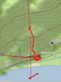
| − | Image:2012-01-10-45 -122 13 but still not right.JPG|So here is a close up of my track, | + | Image:2012-01-10-45 -122 13 but still not right.JPG|So here is a close up of my track, laid over a USGS topo, using DeLorme Topo USA. The hash was, best that I could tell, on the cliff. But the cliff is between the tracks and the river. |
</gallery> | </gallery> | ||
| Line 63: | Line 63: | ||
| − | |||
[[Category:Expeditions]] | [[Category:Expeditions]] | ||
[[Category:Expeditions with photos]] | [[Category:Expeditions with photos]] | ||
[[Category:Coordinates reached]] | [[Category:Coordinates reached]] | ||
Revision as of 23:06, 7 April 2012
| Tue 10 Jan 2012 in 45,-122: 45.5915681, -122.1394323 geohashing.info google osm bing/os kml crox |
Location
By the river.
Participants
Plans
kydlt
I might have to go to this one. I'm heading to Portland anyway.
Expedition
I just got back home (17:44) from an interesting hash trip. I will write it up later.
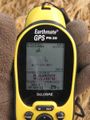
OK, It's later. I have finished coding the pics, but have yet to upload them. I will need a ruling to say if I made it. I started with terrible satellite geometry. One satellite was real high, but the others were all lower than 30 degrees.
My guess from Google maps was that the hash was closer to the river, below the RR tracks, and as it turned out below the cliff (which didn't show up on Google or USGS topos, but that is no surprise). When I finally found a way down there, the GPS claimed that I was midway in the Columbia River. I walked back east as the GPS resolution improved, or so it said, until I was south of the hash, as entered as a waypoint before I started out.
I walked north until I was at the base of the cliff, but the hash was still further north. At this time I worked back around to the tracks, and then to the top of the cliff, and now the GPS said that I needed to be back in the field below. WTF?
As it says when you boot these things, don't bet your life on this locational information. But it was a good wander around, and it made up for all the geohashes that I just drove up to.
Photos
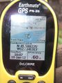
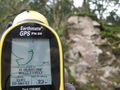
I had terrible satellite geometry. I was definitely still on the road, but the GPS said that I was in the river.
As this track capture shows. For a long time it wouldn't even acquire. Only 1 sat was more than 30 degrees above the horizon.
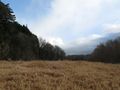
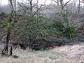
So first I went to the field below the cliffs. I thought the hash would be down here.
But when I was below the tracks & below the cliff, the GPS was showing me up the hill, above the road.
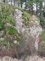
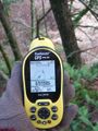
I got to the base of the cliff, the GPS was showing the hash more north, above the cliff.
The numbers were better, the GPS was claiming better accuracy, but.....
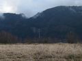
Oh well. I had this view. I believe that to be Multnomah Falls, but I can't see the footpath bridge.
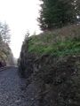
So I climbed back up to the RR tracks.
But still below the road.
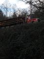
And went up here to arrive to the top of the cliff.
Now that I was here, the GPS said that I should be back down below.
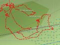
So here is a close up of my track, laid over a USGS topo, using DeLorme Topo USA. The hash was, best that I could tell, on the cliff. But the cliff is between the tracks and the river.


Achievements
- Land Geohash?