Difference between revisions of "2012-01-14 41 -88"
imported>EvilUncleNomo (An expedition message sent via Geohash Droid for Android.) |
imported>FippeBot m (Location) |
||
| (11 intermediate revisions by one other user not shown) | |||
| Line 1: | Line 1: | ||
| − | |||
| − | |||
| − | |||
| − | |||
| − | |||
| − | |||
| − | |||
| − | |||
| − | |||
| − | |||
{{meetup graticule | {{meetup graticule | ||
| lat=41 | | lat=41 | ||
| Line 15: | Line 5: | ||
}} | }} | ||
| − | |||
__NOTOC__ | __NOTOC__ | ||
== Location == | == Location == | ||
| − | + | In a field (covered with snow) off of I-80 near Morris, Illinois, U.S.A. | |
== Participants == | == Participants == | ||
| − | + | * [[User:EvilUncleNomo|EvilUncleNomo]] and [[User:The Wife|The Wife]] | |
== Plans == | == Plans == | ||
| − | + | * [[User:EvilUncleNomo|EvilUncleNomo]] and [[User:The Wife|The Wife]] are planning on attempting this geohash at [[Saturday_meetup|Saturday afternoon at 4:00 p.m.]]. We may even [[Snowman_Geohash|build a snowman]]. | |
== Expedition == | == Expedition == | ||
| − | + | Two days before this attempt we had our first significant snow of the winter so we bundled up in our heavy coats and put on our geohash boots before setting out. It's been fairly warm here (well, above freezing anyway) so we haven't needed the heavy coats up until now, but the boots we've worn on all of our geohashing adventures after the [[2011-10-01 41 -88|first one]]. (Our first attempt was a [http://kelleyeskridge.com.fqdns.net/wp-content/uploads/2008/05/ch-94-learning.gif "learning experience"].) | |
| + | |||
| + | From Lisle, we planned to take I-355 to I-55 to I-80 to the Morris exit, but there was some kind of major traffic backup on I-55, so we quickly rerouted to take I-355 all the way to I-80. This added 7 miles to our trip but probably saves us from sitting in traffic for an hour. | ||
| + | |||
| + | When we got to the site, it was a bit brisk. (Edit: It was COLD Dammit! [[User:The_Wife|-- The Wife]]) The target was an easy walk 270 feet from the road. (Edit: For people with short legs it was a hard walk over uneven snow covered ground! [[User:The_Wife|-- The Wife]]) After the hash we went to a nearby [http://www.mcdonalds.com/us/en/home.html McD's] for hot cocoa. | ||
| − | + | We had talked about building a snowman, but alas the snow wasn't deep enough for a full sized snowman and it wasn't packable in any case. | |
| − | |||
== Photos == | == Photos == | ||
| − | |||
| − | |||
| − | |||
<gallery perrow="5"> | <gallery perrow="5"> | ||
| − | |||
| − | + | Image:2012-01-14_41_-88_16-39-06-837.jpg | Geohash boots | |
| − | |||
| − | |||
| + | Image:2012-01-14_41_-88_16-40-00-525.jpg | Sunset seen from target | ||
| − | + | Image:2012-01-14_41_-88_16-40-54-201.jpg | Cold evil | |
| − | |||
| − | |||
| − | + | Image:2012-01-14_41_-88_16-41-21-798.jpg | Frozen wife | |
| − | + | ||
| − | + | Image:2012-01-14_41_-88_17-01-02-717.jpg | Post-hash caramel hot cocoa | |
| − | --> | + | </gallery> |
| − | |||
[[Category:Expeditions]] | [[Category:Expeditions]] | ||
| − | |||
[[Category:Expeditions with photos]] | [[Category:Expeditions with photos]] | ||
| − | |||
| − | |||
| − | |||
| − | |||
| − | |||
[[Category:Coordinates reached]] | [[Category:Coordinates reached]] | ||
| − | + | {{location|US|IL|GU}} | |
| − | |||
| − | |||
| − | |||
| − | |||
| − | |||
| − | |||
| − | |||
| − | |||
| − | |||
Latest revision as of 04:26, 6 August 2019
| Sat 14 Jan 2012 in 41,-88: 41.3745879, -88.4805336 geohashing.info google osm bing/os kml crox |
Location
In a field (covered with snow) off of I-80 near Morris, Illinois, U.S.A.
Participants
Plans
- EvilUncleNomo and The Wife are planning on attempting this geohash at Saturday afternoon at 4:00 p.m.. We may even build a snowman.
Expedition
Two days before this attempt we had our first significant snow of the winter so we bundled up in our heavy coats and put on our geohash boots before setting out. It's been fairly warm here (well, above freezing anyway) so we haven't needed the heavy coats up until now, but the boots we've worn on all of our geohashing adventures after the first one. (Our first attempt was a "learning experience".)
From Lisle, we planned to take I-355 to I-55 to I-80 to the Morris exit, but there was some kind of major traffic backup on I-55, so we quickly rerouted to take I-355 all the way to I-80. This added 7 miles to our trip but probably saves us from sitting in traffic for an hour.
When we got to the site, it was a bit brisk. (Edit: It was COLD Dammit! -- The Wife) The target was an easy walk 270 feet from the road. (Edit: For people with short legs it was a hard walk over uneven snow covered ground! -- The Wife) After the hash we went to a nearby McD's for hot cocoa.
We had talked about building a snowman, but alas the snow wasn't deep enough for a full sized snowman and it wasn't packable in any case.
Photos
Geohash boots
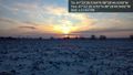
Sunset seen from target

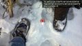
Cold evil

Frozen wife

Post-hash caramel hot cocoa


