Difference between revisions of "2012-01-19 45 -122"
imported>Michael5000 (→Location) |
imported>FippeBot m (Location) |
||
| (12 intermediate revisions by 2 users not shown) | |||
| Line 1: | Line 1: | ||
| − | |||
| − | |||
| − | |||
| − | |||
| − | |||
| − | |||
| − | |||
| − | |||
| − | |||
| − | |||
{{meetup graticule | {{meetup graticule | ||
| lat=45 | | lat=45 | ||
| Line 15: | Line 5: | ||
}} | }} | ||
| − | + | ||
__NOTOC__ | __NOTOC__ | ||
== Location == | == Location == | ||
| − | + | On a cul-de-sac in Happy Valley! | |
== Participants == | == Participants == | ||
| − | + | ||
| + | *[[User:Michael5000|Michael5000]]: Expedition #104 | ||
| + | |||
| + | * [[User:Jiml|Jim]] | ||
== Plans == | == Plans == | ||
| − | + | ||
| + | '''Michael5000''' | ||
| + | |||
| + | I woke up, checked the hashpoints, and planned on driving over the hashpoint on the way to work. | ||
| + | |||
| + | '''Jim''' | ||
| + | |||
| + | Jim noticed the hashpoint seemed accessible as well. He has something in the evening in NE Portland, so going by | ||
| + | on his way home seems plausible. (If the storms permit the trip at all.) | ||
== Expedition == | == Expedition == | ||
| − | |||
| − | + | '''Michael5000''' | |
| − | + | ||
| + | I drove over the hashpoint on the way to work. It was in the street on an unremarkable suburban cul-de-sac. I took a couple of unremarkable photographs, and continued on my way. | ||
| + | |||
| + | I sent Mrs.5000 a note to let her know I had succeeded. "How humdrum life might be," she wrote back, "without these exciting adventures!!!!" | ||
| + | |||
| + | |||
| + | '''Jim''' | ||
| + | Jim went by after his evening meeting (and getting something to eat). The route was fairly | ||
| + | easy, thanks to directions on my handheld. When I got there, I got out of the car to walk to | ||
| + | the hashpoint, but didn't find any markers. Or maybe they got washed away by the wind, | ||
| + | rain, and lots of downed tree branches/debris. | ||
| + | |||
| + | I continued south to head home in a big loop. | ||
| + | |||
== Photos == | == Photos == | ||
| − | + | ||
| − | |||
| − | |||
<gallery perrow="5"> | <gallery perrow="5"> | ||
| + | File:2012-01-17 45 -122 point.JPG|The hashpoint is in the street right there. | ||
| + | File:2012-01-17 45 -122 street.JPG|It has been wet and gloomy around here. For centuries. | ||
| + | File:2012-01-17 45 -122 sign.JPG|I guess I was on Kera Street! | ||
</gallery> | </gallery> | ||
== Achievements == | == Achievements == | ||
{{#vardefine:ribbonwidth|800px}} | {{#vardefine:ribbonwidth|800px}} | ||
| − | |||
| + | * Land Geohash | ||
| + | * Midnight Geohash? (Jim - it was 11:30PM) | ||
| − | |||
| − | |||
| − | |||
| − | |||
| − | |||
| − | |||
| − | |||
| − | |||
| − | |||
[[Category:Expeditions]] | [[Category:Expeditions]] | ||
| − | |||
[[Category:Expeditions with photos]] | [[Category:Expeditions with photos]] | ||
| − | |||
| − | |||
| − | |||
| − | |||
| − | |||
[[Category:Coordinates reached]] | [[Category:Coordinates reached]] | ||
| − | + | {{location|US|OR|CC}} | |
| − | |||
| − | |||
| − | |||
| − | |||
| − | |||
| − | |||
| − | |||
| − | |||
| − | |||
Latest revision as of 02:08, 13 August 2019
| Thu 19 Jan 2012 in 45,-122: 45.4463287, -122.5602004 geohashing.info google osm bing/os kml crox |
Location
On a cul-de-sac in Happy Valley!
Participants
- Michael5000: Expedition #104
Plans
Michael5000
I woke up, checked the hashpoints, and planned on driving over the hashpoint on the way to work.
Jim
Jim noticed the hashpoint seemed accessible as well. He has something in the evening in NE Portland, so going by on his way home seems plausible. (If the storms permit the trip at all.)
Expedition
Michael5000
I drove over the hashpoint on the way to work. It was in the street on an unremarkable suburban cul-de-sac. I took a couple of unremarkable photographs, and continued on my way.
I sent Mrs.5000 a note to let her know I had succeeded. "How humdrum life might be," she wrote back, "without these exciting adventures!!!!"
Jim
Jim went by after his evening meeting (and getting something to eat). The route was fairly
easy, thanks to directions on my handheld. When I got there, I got out of the car to walk to
the hashpoint, but didn't find any markers. Or maybe they got washed away by the wind,
rain, and lots of downed tree branches/debris.
I continued south to head home in a big loop.
Photos
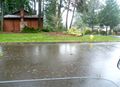
The hashpoint is in the street right there.

It has been wet and gloomy around here. For centuries.
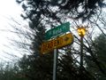
I guess I was on Kera Street!


Achievements
- Land Geohash
- Midnight Geohash? (Jim - it was 11:30PM)