Difference between revisions of "2012-01-28 45 -122"
imported>Jiml (Expand Template) |
imported>FippeBot m (Location) |
||
| (4 intermediate revisions by one other user not shown) | |||
| Line 1: | Line 1: | ||
| + | [[Image:{{{image|2012-01-28 45 -122-FeedMill.jpg}}}|thumb|left]] | ||
| − | |||
| − | |||
| − | |||
| − | |||
| − | |||
| − | |||
| − | |||
| − | |||
| − | |||
{{meetup graticule | {{meetup graticule | ||
| lat=45 | | lat=45 | ||
| Line 15: | Line 7: | ||
}} | }} | ||
| − | + | ||
__NOTOC__ | __NOTOC__ | ||
== Location == | == Location == | ||
| − | + | ||
| + | Front driveway of a house on Maple Street in Downtown Hillsboro | ||
== Participants == | == Participants == | ||
| − | + | ||
| + | * [[User:Jiml|Jim]] | ||
== Plans == | == Plans == | ||
| − | + | ||
| + | Jim can't turn this one down, but he does have to head into Portland around the time of the normal graticule | ||
| + | meetup, so the timing is currently unclear. | ||
| + | |||
| + | Of course, the hashpoint is on private property. It even appears to be *IN* the house, but outside will probably | ||
| + | be within error range. | ||
== Expedition == | == Expedition == | ||
| − | |||
| − | + | I was out doing errands, so I wandered by the hashpoint and took a picture. I didn't ask for | |
| − | + | permission (this time), so we're currently in "No Trespassing" mode. Maybe in an hour or so. | |
| + | |||
| + | Around the regular meeting time, I headed for my appointment in Portland, heading by the | ||
| + | hashpoint (again) on the way. | ||
| + | |||
| + | I arrived and parked, and managed to find one of the introduction sheets and headed for | ||
| + | the front door, watching my GPS on the way. The first discovery was that the house | ||
| + | was actually a duplex, with two street numbers. I headed for the one which was close, | ||
| + | I thought. | ||
| + | |||
| + | However, as I approached the front door, I saw the distance drop to 30 feet and keep going. | ||
| + | And then 15 feet from the front door, it dropped to about 5 feet or so. I decided I | ||
| + | didn't need to bother them, so turned around and headed to my car and to Portland, | ||
| + | grabbing a photo of the local feed mill on the way. | ||
| + | |||
| + | Guess Google Maps was a tad off. I'll have to run an experiment at home | ||
| + | and see if I can figure out what's going on. | ||
| + | |||
== Photos == | == Photos == | ||
| − | + | ||
| − | |||
| − | |||
<gallery perrow="5"> | <gallery perrow="5"> | ||
| + | Image:2012-01-28 45 -122 Hashpoint.jpg|The hashpoint from afar - Trip 1 | ||
| + | Image:2012-01-28 45 -122-FeedMill.jpg|The FeedMill near the hashpoint - Trip 2 | ||
| + | Image:2012-01-28 45 -122-street.jpg|The street near the hashpoint - Trip 2 | ||
</gallery> | </gallery> | ||
== Achievements == | == Achievements == | ||
{{#vardefine:ribbonwidth|800px}} | {{#vardefine:ribbonwidth|800px}} | ||
| − | |||
| − | + | * Land Geohash | |
| − | + | ||
| − | + | ||
| + | |||
| + | |||
| − | |||
| − | |||
| − | |||
| − | |||
| − | |||
[[Category:Expeditions]] | [[Category:Expeditions]] | ||
| − | |||
[[Category:Expeditions with photos]] | [[Category:Expeditions with photos]] | ||
| − | + | ||
| − | |||
| − | |||
| − | |||
| − | |||
[[Category:Coordinates reached]] | [[Category:Coordinates reached]] | ||
| − | + | {{location|US|OR|WI}} | |
| − | |||
| − | |||
| − | |||
| − | |||
| − | |||
| − | |||
| − | |||
| − | |||
| − | |||
Latest revision as of 02:13, 13 August 2019

| Sat 28 Jan 2012 in 45,-122: 45.5144893, -122.9874734 geohashing.info google osm bing/os kml crox |
Location
Front driveway of a house on Maple Street in Downtown Hillsboro
Participants
Plans
Jim can't turn this one down, but he does have to head into Portland around the time of the normal graticule meetup, so the timing is currently unclear.
Of course, the hashpoint is on private property. It even appears to be *IN* the house, but outside will probably be within error range.
Expedition
I was out doing errands, so I wandered by the hashpoint and took a picture. I didn't ask for permission (this time), so we're currently in "No Trespassing" mode. Maybe in an hour or so.
Around the regular meeting time, I headed for my appointment in Portland, heading by the hashpoint (again) on the way.
I arrived and parked, and managed to find one of the introduction sheets and headed for the front door, watching my GPS on the way. The first discovery was that the house was actually a duplex, with two street numbers. I headed for the one which was close, I thought.
However, as I approached the front door, I saw the distance drop to 30 feet and keep going. And then 15 feet from the front door, it dropped to about 5 feet or so. I decided I didn't need to bother them, so turned around and headed to my car and to Portland, grabbing a photo of the local feed mill on the way.
Guess Google Maps was a tad off. I'll have to run an experiment at home and see if I can figure out what's going on.
Photos
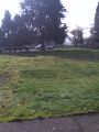
The hashpoint from afar - Trip 1
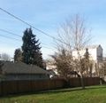
The FeedMill near the hashpoint - Trip 2
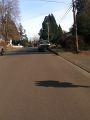
The street near the hashpoint - Trip 2


Achievements
- Land Geohash