2012-01-29 51 11
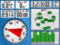
| Sun 29 Jan 2012 in 51,11: 51.0125897, 11.4476091 geohashing.info google osm bing/os kml crox |
Location
On a field near Ulrichshalben.
Participants
Expedition (Rincewind)
We thought we'd use the day for some hashing and found the location within sane driving distance and reachable. Salta and me let the TomTom navigate us within the street leading to the gravel path next to the hash field and then just drove on until we were within some 150m of the hash coordinates. On our way we overtook some people pulling some sleds. When we entered the frozen field, we saw some more tracks, two from people with skis on the lower border of the field, and some foot and bike marks going uphill leading straight to the coordinates. Geohashers! And we noted the hare tracks, as well. :)
It was fairly clear someone was there before us, I guessed it must have been Reinhard or Juja. Indeed, when we reached the coordinates, some three meters above us the bike tracks turned around in a circle of a few meters. Nice accuracy. :)
Took the photos and headed home, trying to view Ordensburg (Castle of the order) Liebstedt, but it was closed this day. Instead, I relaxedly ran into a speed camera on the way home while not realising I had entered a town community from the country road. :(
Tracklog (Rincewind)
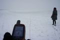
Photos (Rincewind)
Proof...
Salta simply following Juja's track...
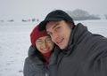
No comment.
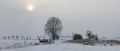
Winter panorama taken from the geohash site
Certainly not a new temperature record.


Expedition (Juja)
Rincewind was right, there was a bike Geohasher at the point before him... I'm very sorry I didn't mark the point because I knew Reinhard wouldn't visit the point today and didn't suspect anyone else!
I started to cycle to today's Geohash shortly before lunch (right after my breakfast:) from Jena up to Cospeda through the lots of snow that had surprisingly fallen yesterday (I met two groups of strollers on my way and got lots of "Chapeau!" even though what I was doing was mere stupidity - people were skiing on my cycleways!) I knew my way to Apolda, Oberreißen and it also wasn't difficult to find the point in the snowy fields (although it was a bit difficult to get there by bike in this kind of weather). I took the usual photos and cycled back home, not having seen any other Hashers :(
My original plan was to add the usual cultural touch to the tour by going back through Weimar, but it was really cold, Friday's Christmas Carols were replaced by "this *** is bananas... B A N A N A S" (btw: bananas almost freeze on tours like this even if you put them really deep in the backpack) so I took the shortcut via Umpferstedt and Mellingen and arrived at home right on time for some cake and glühwein.
Photos: Juja
|


Achievements

Juja, Salta and Rincewind earned the Land geohash achievement
|