Difference between revisions of "2012-02-06 78 15"
imported>Relet (An expedition message sent via Geohash Droid for Android.) |
m (per Renaming Proposal) |
||
| (10 intermediate revisions by 2 users not shown) | |||
| Line 1: | Line 1: | ||
| − | |||
| − | |||
| − | |||
| − | |||
| − | |||
| − | |||
| − | |||
| − | |||
| − | |||
| − | |||
{{meetup graticule | {{meetup graticule | ||
| lat=78 | | lat=78 | ||
| Line 18: | Line 8: | ||
__NOTOC__ | __NOTOC__ | ||
== Location == | == Location == | ||
| − | + | Longyearbyen, Svalbard | |
| + | |||
| + | {{Template:PBGH battleship|lat=78|lon=15|date=2012-02-06}} | ||
== Participants == | == Participants == | ||
| − | + | * [[User:relet|relet]] | |
| + | * his brother | ||
== Plans == | == Plans == | ||
| − | + | Since the hash popped up at a distance of just 1.9km of our residence, on the side of a cliff, I considered just walking there and see how far I get. | |
| + | Before that, I had considered renting dogsleds, guns, scare flares, and/or skis to reach a geohash in a remote valley, in arctic temperatures, while surrounded by polar bars. | ||
| + | |||
| + | Fun fact: Svalbard has 2500 human inhabitants, and 4500 polar bears. | ||
== Expedition == | == Expedition == | ||
| − | + | As the weather gods wanted it, Svalbard got its annual share of rain in just three days, right before we arrived. That means, while the rest of Norway (and large parts of Europe) suffered from temperatures in the -10C range, they were granted something on the positive end of the scale. This resulted in a frozen airport (our plane was the first one that got through), burst bridges (I still don't know how that happened - probably sheets of ice), avalanches (lots of them) and too little snow. Basically all tracks outside of town were closed, all guided tours canceled. Fortunately, we had the [http://polarjazz.no PolarJazz Festival] to entertain us. | |
| + | |||
| + | As the geohashing gods wanted it, they put an easily accessible geohash inside town. On a monday. That means three theoretical days of preparation. | ||
| + | |||
| + | I used none of that preparation, and put on warm clothes and some spiked soles, and took my brother for a walk. The road to the geohash was well illuminated, and we happily chatted and walked away. Some reindeer stood next to the road, blissfully unaware of the presence of geohashes. | ||
| + | |||
| + | Some 100m downhill from the location, we discovered a service station, with an access track. We also discovered that the geohash was right next to one of the poles of the former ropeway that was used to transport coal from the mines to the port. Not too much hash dancing needed, and there was a sort of track uphill to the pole. Thanks to the spiked soles, I managed to find a hold on the iced over snow and rubble, and reached the geohash without much issues. My brother, for lack of spiked soles, decided to stay downhills. | ||
| − | + | After recording the necessary proof, I turned around and... discovered that I wouldn't find the same foothold while walking down - not even backwards. It had been on the edge of slipping on the uphill direction already. So I decided to sit on my derrière and tobbogan back down. That went surprisingly well and was fun, and I managed not to hit any of the various rocks with my rocks. I also managed to shoot one of my spiked soles (which are made of rubber and attached to your shoes) while braking into a perpendicular direction, slingshot style, and to scare a herd of five reindeer that kept my brother company while he observed my attempts. | |
| − | |||
== Photos == | == Photos == | ||
| − | |||
| − | |||
| − | |||
<gallery perrow="5"> | <gallery perrow="5"> | ||
| − | |||
| − | == | + | Image:2012-02-06_78_15_00-32-06-345.jpg | Arctic walk geohash? Coordinates vorking reached! [http://www.openstreetmap.org/?lat=78.20468005&lon=15.57146899&zoom=16&layers=B000FTF @78.2047,15.5715] |
| − | + | ||
| − | + | Image:2012-02-06_78_15_00-34-23-468.jpg | Stupid grin. There might be polar bears. [http://www.openstreetmap.org/?lat=78.20467059&lon=15.57140211&zoom=16&layers=B000FTF @78.2047,15.5714] | |
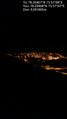
| + | File:2012-02-06 78 15 Adventsdalen.jpg | Higher quality view of Longyearbyen from the hash | ||
| + | File:2012-02-06 78 15 R1064755.JPG | The moon and the cable car | ||
| + | File:2012-02-06 78 15 R1064756.JPG | Reindeer tracks at the hash | ||
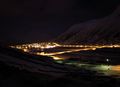
| + | File:2012-02-06 78 15 R1064761.JPG | View from our hotel window towards the hash (on the right side, but probably behind the bend) - you can see the cable car poles | ||
| − | < | + | </gallery> |
| − | |||
| − | |||
| − | + | == Achievements == | |
| − | + | {{North geohash|date=2012-02-06|latitude=78|longitude=15}} | |
| − | [[ | + | {{Graticule unlocked|latitude=78|longitude=15|date=2012-02-06}} |
| − | + | {{gratuitous ribbon | |
| + | | color = navy | ||
| + | | icon = NorthSouth.png | ||
| + | | latitude = 78 | ||
| + | | longitude = 15 | ||
| + | | date = 2012-02-06 | ||
| + | | achievement = North & South combo achievement | ||
| + | | description = reaching both the northernmost and the southernmost geohash at any given time, with the | ||
| + | | name = [[User:relet|relet]] | ||
| + | }} | ||
| − | + | [[Category:Expeditions]] | |
| − | [[Category:Expeditions]] | ||
| − | |||
[[Category:Expeditions with photos]] | [[Category:Expeditions with photos]] | ||
| − | |||
| − | |||
| − | |||
| − | |||
| − | |||
[[Category:Coordinates reached]] | [[Category:Coordinates reached]] | ||
| − | + | {{location|SJ|S}} | |
| − | |||
| − | |||
| − | |||
| − | |||
| − | |||
| − | |||
| − | |||
| − | |||
| − | |||
Latest revision as of 05:45, 20 March 2024
| Mon 6 Feb 2012 in 78,15: 78.2046689, 15.5718635 geohashing.info google osm bing/os kml crox |
Location
Longyearbyen, Svalbard
Today's battleship location is: F 3
Participants
- relet
- his brother
Plans
Since the hash popped up at a distance of just 1.9km of our residence, on the side of a cliff, I considered just walking there and see how far I get. Before that, I had considered renting dogsleds, guns, scare flares, and/or skis to reach a geohash in a remote valley, in arctic temperatures, while surrounded by polar bars.
Fun fact: Svalbard has 2500 human inhabitants, and 4500 polar bears.
Expedition
As the weather gods wanted it, Svalbard got its annual share of rain in just three days, right before we arrived. That means, while the rest of Norway (and large parts of Europe) suffered from temperatures in the -10C range, they were granted something on the positive end of the scale. This resulted in a frozen airport (our plane was the first one that got through), burst bridges (I still don't know how that happened - probably sheets of ice), avalanches (lots of them) and too little snow. Basically all tracks outside of town were closed, all guided tours canceled. Fortunately, we had the PolarJazz Festival to entertain us.
As the geohashing gods wanted it, they put an easily accessible geohash inside town. On a monday. That means three theoretical days of preparation.
I used none of that preparation, and put on warm clothes and some spiked soles, and took my brother for a walk. The road to the geohash was well illuminated, and we happily chatted and walked away. Some reindeer stood next to the road, blissfully unaware of the presence of geohashes.
Some 100m downhill from the location, we discovered a service station, with an access track. We also discovered that the geohash was right next to one of the poles of the former ropeway that was used to transport coal from the mines to the port. Not too much hash dancing needed, and there was a sort of track uphill to the pole. Thanks to the spiked soles, I managed to find a hold on the iced over snow and rubble, and reached the geohash without much issues. My brother, for lack of spiked soles, decided to stay downhills.
After recording the necessary proof, I turned around and... discovered that I wouldn't find the same foothold while walking down - not even backwards. It had been on the edge of slipping on the uphill direction already. So I decided to sit on my derrière and tobbogan back down. That went surprisingly well and was fun, and I managed not to hit any of the various rocks with my rocks. I also managed to shoot one of my spiked soles (which are made of rubber and attached to your shoes) while braking into a perpendicular direction, slingshot style, and to scare a herd of five reindeer that kept my brother company while he observed my attempts.
Photos
Arctic walk geohash? Coordinates vorking reached! @78.2047,15.5715

Stupid grin. There might be polar bears. @78.2047,15.5714
Higher quality view of Longyearbyen from the hash
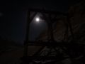
The moon and the cable car
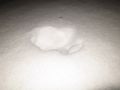
Reindeer tracks at the hash
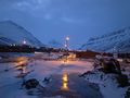
View from our hotel window towards the hash (on the right side, but probably behind the bend) - you can see the cable car poles


Achievements
This user earned the North geohash achievement
|
This user earned the Graticule Unlocked Achievement
|
relet earned the North & South combo achievement
|