Difference between revisions of "2012-02-09 59 18"
imported>Cjk ([live picture] Panorama 2 [http://www.openstreetmap.org/?lat=59.50882872&lon=18.12949271&zoom=16&layers=B000FTF @59.5088,18.1295]) |
imported>FippeBot m (Location) |
||
| (14 intermediate revisions by 3 users not shown) | |||
| Line 1: | Line 1: | ||
| + | [[Image:{{{image|2012-02-09_59_18_11-01-25-102.jpg}}}|thumb|left]] | ||
| − | |||
| − | |||
| − | |||
| − | |||
| − | |||
| − | |||
| − | |||
| − | |||
| − | |||
{{meetup graticule | {{meetup graticule | ||
| lat=59 | | lat=59 | ||
| Line 19: | Line 11: | ||
== Location == | == Location == | ||
<!-- where you've surveyed the hash to be --> | <!-- where you've surveyed the hash to be --> | ||
| + | Smack in the middle of Gävsjövägen in the woods east of Täby Kyrkby. | ||
== Participants == | == Participants == | ||
<!-- who attended --> | <!-- who attended --> | ||
| + | [[User:Cjk|Carl-Johan]] | ||
== Plans == | == Plans == | ||
<!-- what were the original plans --> | <!-- what were the original plans --> | ||
| + | I was gonna drop off my dads car near Lidingö this morning so why not do a hash on the way. | ||
| + | |||
| + | After dropping the car off I planned to do some retro hashing so I took the 5 closes to the auto shop towards the Metro near Karlaplan. I was trying out my new code for showing all retros through history around your position. I managed to do these 5: | ||
| + | |||
| + | *[[2004-12-04 59 18]] | ||
| + | *[[2004-11-12 59 18]] | ||
| + | *[[1980-07-07 59 18]] | ||
| + | *[[1964-02-21 59 18]] | ||
| + | *[[1966-12-01 59 18]] | ||
== Expedition == | == Expedition == | ||
<!-- how it all turned out. your narrative goes here. --> | <!-- how it all turned out. your narrative goes here. --> | ||
| + | I hopped in the car around 0900 and it was cold and a lot of snow on the car and on the ground. I went to Sollentuna to buy some gloves cause I had lost one the week before and it's been very cold. After Sollentuna it was an easy drive towards Täby Kyrkby and I followed Google Navigate that told me to take a right and go onto Roslagsvägen. But after a kilometer I encountered big boulders and the road was totally closed. And absolutely no parking. Except for the car that someone had broken into and was dumped with the plates removed. I backtracked to Täby Kyrkby and they were building like crazy there. Found the tiny little road that was Gävsjövägen that started taking me towards the hash. I went past more and more houses and farms and further into the woods. | ||
| + | I found the hash and drove right through it seeing geohash droid go down to just a few meters. I stopped and backed up, went out and took some pictures. It was a nice and sunny at this point. As I was uploading to the gallery a car with an older lady came from the other direction. I hopped into my dad's car and drove backwards to a meeting point on the road, since I needed a run up to try a speed racer achievement. it was really hard getting enough traction to get it up to 50 km/h which was the legal limit here, but I managed. Tried it again since I couldn't tell if the speed was showing in the first picture or not but it turns out the second try was worse. | ||
| − | *Snow speed racer -- [[User:Cjk| | + | Since my dad was borrowing my car I did not have any Orange<sup>tm</sup> with me so no marking, but I continued south on the road. That car must have come from somewhere and if there was fresh car tracks in the snow that means it could not end up in the rocks blocking off the street I had seen before. As I emerged from a tunnel under the 265 I got onto Roslagsvägen. I had entered the address of the auto shop in Google Navigate and again, it told me to take a left and drive into the fat blocks in the middle of the road. Damn you non-working technology! |
| − | + | ||
| − | + | I found another route which was actually probably shorter and got to the auto shop and dropped the car off. I was wearing my Icebug shoes with metal studs and extra layers of clothes for a walk home and some Retro Hashing! Onto [[2004-12-04 59 18]] | |
| + | |||
| + | *Snow speed racer -- [[User:Cjk|Carl-Johan]] [http://www.openstreetmap.org/?lat=59.51271240&lon=18.09697410&zoom=16&layers=B000FTF @59.5127,18.0970] 10:57, 09 February 2012 (CET) | ||
== Photos == | == Photos == | ||
| Line 39: | Line 46: | ||
--> | --> | ||
<gallery perrow="5"> | <gallery perrow="5"> | ||
| + | |||
| + | Image:2012-02-09_59_18_14-25-06-397.jpg | No entry, no parking, EVER! | ||
Image:2012-02-09_59_18_11-01-25-102.jpg | [http://www.openstreetmap.org/?lat=59.50890000&lon=18.12940000&zoom=16&layers=B000FTF @59.5089,18.1294] | Image:2012-02-09_59_18_11-01-25-102.jpg | [http://www.openstreetmap.org/?lat=59.50890000&lon=18.12940000&zoom=16&layers=B000FTF @59.5089,18.1294] | ||
| Line 45: | Line 54: | ||
Image:2012-02-09_59_18_11-02-34-398.jpg | Panorama 2 [http://www.openstreetmap.org/?lat=59.50882872&lon=18.12949271&zoom=16&layers=B000FTF @59.5088,18.1295] | Image:2012-02-09_59_18_11-02-34-398.jpg | Panorama 2 [http://www.openstreetmap.org/?lat=59.50882872&lon=18.12949271&zoom=16&layers=B000FTF @59.5088,18.1295] | ||
| + | |||
| + | Image:2012-02-09_59_18_14-27-28-868.jpg | Snow speed racer! | ||
| + | |||
| + | Image:2012-02-09_59_18_14-29-36-519.jpg | Motion blur | ||
| + | |||
| + | Image:2012-02-09_59_18_14-30-35-774.jpg | Also no entry from this way. | ||
</gallery> | </gallery> | ||
| Line 50: | Line 65: | ||
{{#vardefine:ribbonwidth|800px}} | {{#vardefine:ribbonwidth|800px}} | ||
<!-- Add any achievement ribbons you earned below, or remove this section --> | <!-- Add any achievement ribbons you earned below, or remove this section --> | ||
| + | {{Land geohash | latitude = 59 | longitude = 18 | date = 2012-02-09 | name = [[User:Cjk|Carl-Johan]] }} | ||
| + | {{Speed racer | latitude = 59 | longitude = 18 | date = 2012-02-09 | name = [[User:Cjk|Carl-Johan]] | image = 2012-02-09_59_18_14-27-28-868.jpg }} | ||
| + | {{Frozen Geohash | latitude = 59 | longitude = 18 | date = 2012-02-09 | name = [[User:Cjk|Carl-Johan]] | temperature = -6°C }} | ||
| + | [[Category:Expeditions]] | ||
| − | + | [[Category:Expeditions with photos]] | |
| − | |||
| − | [[Category: | ||
| − | |||
| − | |||
| − | |||
| − | |||
| − | |||
| − | |||
| − | |||
| − | |||
| − | |||
| − | |||
| − | |||
| − | |||
| − | |||
| − | |||
[[Category:Coordinates reached]] | [[Category:Coordinates reached]] | ||
| − | + | {{location|SE|AB}} | |
| − | |||
| − | |||
| − | |||
| − | |||
| − | |||
| − | |||
| − | |||
| − | |||
| − | |||
Latest revision as of 02:21, 13 August 2019

| Thu 9 Feb 2012 in 59,18: 59.5088608, 18.1294899 geohashing.info google osm bing/os kml crox |
Location
Smack in the middle of Gävsjövägen in the woods east of Täby Kyrkby.
Participants
Plans
I was gonna drop off my dads car near Lidingö this morning so why not do a hash on the way.
After dropping the car off I planned to do some retro hashing so I took the 5 closes to the auto shop towards the Metro near Karlaplan. I was trying out my new code for showing all retros through history around your position. I managed to do these 5:
Expedition
I hopped in the car around 0900 and it was cold and a lot of snow on the car and on the ground. I went to Sollentuna to buy some gloves cause I had lost one the week before and it's been very cold. After Sollentuna it was an easy drive towards Täby Kyrkby and I followed Google Navigate that told me to take a right and go onto Roslagsvägen. But after a kilometer I encountered big boulders and the road was totally closed. And absolutely no parking. Except for the car that someone had broken into and was dumped with the plates removed. I backtracked to Täby Kyrkby and they were building like crazy there. Found the tiny little road that was Gävsjövägen that started taking me towards the hash. I went past more and more houses and farms and further into the woods.
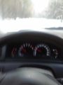
I found the hash and drove right through it seeing geohash droid go down to just a few meters. I stopped and backed up, went out and took some pictures. It was a nice and sunny at this point. As I was uploading to the gallery a car with an older lady came from the other direction. I hopped into my dad's car and drove backwards to a meeting point on the road, since I needed a run up to try a speed racer achievement. it was really hard getting enough traction to get it up to 50 km/h which was the legal limit here, but I managed. Tried it again since I couldn't tell if the speed was showing in the first picture or not but it turns out the second try was worse.
Since my dad was borrowing my car I did not have any Orangetm with me so no marking, but I continued south on the road. That car must have come from somewhere and if there was fresh car tracks in the snow that means it could not end up in the rocks blocking off the street I had seen before. As I emerged from a tunnel under the 265 I got onto Roslagsvägen. I had entered the address of the auto shop in Google Navigate and again, it told me to take a left and drive into the fat blocks in the middle of the road. Damn you non-working technology!
I found another route which was actually probably shorter and got to the auto shop and dropped the car off. I was wearing my Icebug shoes with metal studs and extra layers of clothes for a walk home and some Retro Hashing! Onto 2004-12-04 59 18
- Snow speed racer -- Carl-Johan @59.5127,18.0970 10:57, 09 February 2012 (CET)
Photos
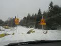
No entry, no parking, EVER!
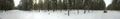
Panorama 1 @59.5088,18.1295
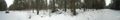
Panorama 2 @59.5088,18.1295
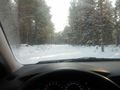
Snow speed racer!
Motion blur
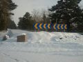
Also no entry from this way.


Achievements
Carl-Johan earned the Land geohash achievement
|

