Difference between revisions of "2012-02-20 52 1"
imported>Sourcerer ([live] Arrived) |
imported>FippeBot m (Location) |
||
| (4 intermediate revisions by one other user not shown) | |||
| Line 1: | Line 1: | ||
| − | |||
| − | |||
| − | |||
| − | |||
| − | |||
| − | |||
| − | |||
| − | |||
| − | |||
| − | |||
{{meetup graticule | {{meetup graticule | ||
| − | | lat=52 | + | | lat=52 |
| − | | lon=1 | + | | lon=1 |
| − | | date=2012-02-20 | + | | date=2012-02-20 |
| + | | graticule_name=Norwich | ||
| + | | graticule_link=Norwich, United Kingdom | ||
}} | }} | ||
| − | |||
| − | |||
== Location == | == Location == | ||
| − | + | ||
| + | Near a multi tonne farmyard manure pile 1.5 km north of Burgh St. Peter, Norfolk, UK. | ||
== Participants == | == Participants == | ||
| − | |||
| − | + | [[User:Sourcerer|Sourcerer]] | |
| − | |||
== Expedition == | == Expedition == | ||
| − | |||
| + | *Arrived -- [[User:Sourcerer|Sourcerer]] [http://www.openstreetmap.org/?lat=52.498056292533875&lon=1.6267168521881104&zoom=16&layers=B000FTF @52.4981,1.6267] 17:30, 20 February 2012 (GMT) | ||
| + | |||
| + | The hashpoint was close to my commute home and only a few metres from a public footpath. This should be an easy expedition and indeed it was but not without interest. My departure was delayed because I had to move a microwave oven into my workplace. This involved trolleys and lifts and took some time so the daylight was fading fast as I set out. | ||
| + | |||
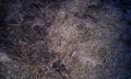
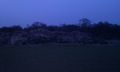
| + | There was a safe place to park right at the start of the footpath which was marked by a sizeable sarson stone. The track to the hashpoint was easy to follow and the snowdrops blooming in the grass and under the trees were shining in the twilight. Near the hashpoint it became obvious that there was a very large, fragrant agricultural manure pile really close to the destination. A small diversion round the end of the pile led to the hash a few paces into a field of winter wheat. This was a near-miss poo-pile hash. | ||
| + | |||
| + | I was gathering tracklog data for OpenStreetmap because the footpath was missing from their database. This became interesting as it got very dark and the path signposting became increasingly difficult to see. I eventually reached the road with only one wrong turning. | ||
| − | |||
== Tracklog == | == Tracklog == | ||
| − | |||
| − | + | This walk has been logged at [http://en.wikiloc.com/wikiloc/view.do?id=2510718 Wikiloc]. | |
| − | |||
| − | |||
| − | |||
| − | |||
| − | |||
== Achievements == | == Achievements == | ||
| − | |||
| − | |||
| + | {{OpenStreetMap Achievement | ||
| + | | latitude = 52 | ||
| + | | longitude = 1 | ||
| + | | date =2012-02-20 | ||
| + | | OSMlink = 10744476 | ||
| + | | name = Sourcerer | ||
| + | }} | ||
| − | + | == Photo Gallery == | |
| − | |||
| − | |||
| − | < | + | <gallery> |
| − | + | Image:2012-02-20 52 1 Sourcerer 0.jpg|Google Earth Tracklog | |
| − | + | Image:2012-02-20 52 1 Sourcerer 1.jpg|The Standing Stone | |
| − | -- | + | Image:2012-02-20 52 1 Sourcerer 2.jpg|The Poo Pile |
| + | Image:2012-02-20 52 1 Sourcerer 3.jpg|Poo Pile Close Up | ||
| + | </gallery> | ||
| + | |||
| + | {{Sourcerer_links | ||
| + | | prev = 2012-02-13 51 -2 | ||
| + | | curr = 2012-02-20 52 1 | ||
| + | | next = 2012-03-12 52 1 | ||
| + | | date = 2012-02-20 | ||
| + | }} | ||
| − | |||
[[Category:Expeditions]] | [[Category:Expeditions]] | ||
| − | |||
[[Category:Expeditions with photos]] | [[Category:Expeditions with photos]] | ||
| − | |||
| − | |||
| − | |||
| − | |||
| − | |||
[[Category:Coordinates reached]] | [[Category:Coordinates reached]] | ||
| − | + | {{location|GB|ENG|NFK}} | |
| − | |||
| − | |||
| − | |||
| − | |||
| − | |||
| − | |||
| − | |||
| − | |||
| − | |||
Latest revision as of 02:27, 13 August 2019
| Mon 20 Feb 2012 in Norwich: 52.4981044, 1.6267383 geohashing.info google osm bing/os kml crox |
Contents
Location
Near a multi tonne farmyard manure pile 1.5 km north of Burgh St. Peter, Norfolk, UK.
Participants
Expedition
- Arrived -- Sourcerer @52.4981,1.6267 17:30, 20 February 2012 (GMT)
The hashpoint was close to my commute home and only a few metres from a public footpath. This should be an easy expedition and indeed it was but not without interest. My departure was delayed because I had to move a microwave oven into my workplace. This involved trolleys and lifts and took some time so the daylight was fading fast as I set out.
There was a safe place to park right at the start of the footpath which was marked by a sizeable sarson stone. The track to the hashpoint was easy to follow and the snowdrops blooming in the grass and under the trees were shining in the twilight. Near the hashpoint it became obvious that there was a very large, fragrant agricultural manure pile really close to the destination. A small diversion round the end of the pile led to the hash a few paces into a field of winter wheat. This was a near-miss poo-pile hash.
I was gathering tracklog data for OpenStreetmap because the footpath was missing from their database. This became interesting as it got very dark and the path signposting became increasingly difficult to see. I eventually reached the road with only one wrong turning.
Tracklog
This walk has been logged at Wikiloc.
Achievements
Sourcerer earned the OpenStreetMap achievement
|
Photo Gallery
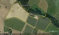
Google Earth Tracklog
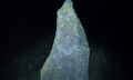
The Standing Stone
The Poo Pile
Poo Pile Close Up


Expeditions and Plans
| 2012-02-20 | ||
|---|---|---|
| Crestview, Florida | Liberian | On the Eglin range, up about a mile from the Timberlake hiking trails and c... |
| Portland, Oregon | Michael5000, kydlt, Jim | On the campus of the Parry Center for Children in Southeast Portland. |
| Seattle, Washington | OtherJack | A vehicle storage lot in a private subdivision south of Port Orchard |
| Bruxelles, Belgium | Tyros | In an open field between Charleroi & Namur. |
| Norwich, United Kingdom | Sourcerer | Near a multi tonne farmyard manure pile 1.5 km north of Burgh St. Peter, No... |
| Uppsala, Sweden | Carl-Johan | Right by the road leading up to Bro Hof Castle, which now seems to be a gol... |
Sourcerer's Expedition Links
2012-02-13 51 -2 - 2012-02-20 52 1 - 2012-03-12 52 1 - KML file download of Sourcerer's expeditions for use with Google Earth.