Difference between revisions of "2012-03-02 58 18"
imported>Cjk ([live picture] [http://www.openstreetmap.org/?lat=58.98280000&lon=18.00950000&zoom=16&layers=B000FTF @58.9828,18.0095]) |
m (per Renaming Proposal) |
||
| (26 intermediate revisions by 5 users not shown) | |||
| Line 1: | Line 1: | ||
| − | + | [[Image:{{{image|2012-03-02_58_18_16-07-05-468.jpg}}}|thumb|left]] | |
| − | |||
| − | |||
| − | [[Image:{{{image| | ||
| − | |||
| − | |||
| − | |||
| − | |||
| − | |||
| − | |||
{{meetup graticule | {{meetup graticule | ||
| lat=58 | | lat=58 | ||
| Line 17: | Line 8: | ||
<!-- edit as necessary --> | <!-- edit as necessary --> | ||
__NOTOC__ | __NOTOC__ | ||
| + | == READ THIS FIRST == | ||
| + | '''Do not attempt this if you are not prepared! Spring ice is really dangerous. I have cut holes in the ice and swum in 0°C water before, I was wearing ice safety picks at all times, I was wearing a wet suit in case I went through the ice, I had checked the ice map beforehand and I had a person on stand-by on land watching over me.''' | ||
| + | |||
== Location == | == Location == | ||
| − | + | ||
| + | On the ice 50m from a tiny island, 530 m from the nearest island reachable by car, Herrö, near Muskö. Closest island with a name south of the hash was Björkholmen. | ||
== Participants == | == Participants == | ||
| − | + | ||
| + | *[[User:Cjk|Carl-Johan]] | ||
| + | *[[User:TheNuclearScientist|TheNuclearScientist]] for safety | ||
== Plans == | == Plans == | ||
| − | + | ||
| + | I had been watching for hashes in [[Utö, Sweden]] for a long time. It is like 99% Baltic Sea so it is really a long shot to try to get a hash in here. But on Thursday I saw that the coords where up in the NW corner, fairly close to land, like 500 or so, and inside the ring of outer islands. The weather has been thawing for some time now but it was really cold in February so this might be reachable with a lot of preparation. I checked the [http://www.smhi.se/oceanografi/istjanst/is_prod.php Icemap] from SMHI and it said 5-15 cm, rotten ice. Rotten ice can mean anything so it could be safe or totally unsafe, only way to be sure was to check it out. Ice types explained [http://www.smhi.se/en/theme/sea-ice-1.11198 here]. | ||
== Expedition == | == Expedition == | ||
| − | + | ||
| + | My dad and I headed off some time after 14 in the afternoon towards Muskö, the | ||
| + | secret island. We stopped at Biltema and bought some more Orange™ and an | ||
| + | inflatable kiddy boat, just in case it wasn't all ice. Gotta be prepared. We | ||
| + | continued down to the islands and turned of at a tiny gravel road on Herrö, the | ||
| + | "Gentleman Island". After a twisty muddy road we got to the closest place on | ||
| + | land. Parked away from the house that was closest to the water, got my | ||
| + | gear and went around their yard to the water. | ||
| + | |||
| + | The ice looked pretty good from here, not open water as had been the case | ||
| + | under the bridge that took us here, but that was streaming water and | ||
| + | this looked promising. Still, the first 2 m was just broken patches | ||
| + | of ice so the hardest part looked like the first step. We found a | ||
| + | nice plank to use and some wood to make a makeshift gangplank | ||
| + | halfway out to the main ice sheet. I got into my wet suit, put | ||
| + | the phone in a waterproof case and got out my ice safety picks | ||
| + | while dad was blowing up the kiddy boat. After all, I had no idea of the conditions further out and it was still 530 m to the hash. | ||
| + | |||
| + | [[Image:2012-03-02_58_18_00-01-40-240.jpg|200px]] | ||
| + | |||
| + | I put the plank and the other wood onto the ice and laid down on the | ||
| + | kiddy boat on my stomach and started inching my way to the real ice | ||
| + | edge before the ice I was on sank. The kiddy boat was the worst ever | ||
| + | and leaked from a hole in the bottom so it was only useful for those | ||
| + | 2m. Throw that shit away. Fucking Biltema quality. 5€ down the drain. | ||
| + | The ice seemed solid and okay. Not so rotten as I had thought. You could | ||
| + | still see lots of bubbles in it and it was not as solid as the nice | ||
| + | blue ice you really want but it didn't give at all when you jumped on | ||
| + | it. Still I was cautious. I ventured further and further from land, | ||
| + | walking upright, using the plank to hammer on the ice every few | ||
| + | meters. I had my IceBug shoes with spikes underneath so footing | ||
| + | was not a problem. After 100m I realized I had forgotten my Orange™ | ||
| + | but I didn't have a free hand anyway so we decided to skip it. | ||
| + | Stopped at 200m out and took a pic and surveyed everything. | ||
| + | The ice was roughly 10cm and I could not find any real weakness in it. | ||
| + | |||
| + | I continued onward to the Island I knew the hash was close to, checking | ||
| + | the ice all the time. You fool yourself into thinking that the dark | ||
| + | parts are the thin parts but actually the dark parts are the strong | ||
| + | parts and the lite parts are the weak parts of the ice. I was getting | ||
| + | closer and closer. I picked up the phone when I had 30m to go and | ||
| + | navigated straight to the hash. Sat down and took some nice pics. | ||
| + | |||
| + | And yes, those are rubber gloves in case I needed to stick my hand | ||
| + | into the freezing water. | ||
| + | |||
| + | [[Image:2012-03-02_58_18_16-05-33-591.jpg|800px]] | ||
| + | |||
| + | After uploading all pics I started heading back exactly the same way I | ||
| + | came. I knew that that ice had held my weight going out so I could walk | ||
| + | faster on the way back. Got to the edge of the ice and snapped a pic of | ||
| + | dad and I put the phone on a stick he was holding out so he could snap | ||
| + | a pic of me. I used the plank and the stick to traverse the last 1.5m | ||
| + | which of course was the hardest part, and the back on dry land, and I | ||
| + | was completely dry as well. | ||
| + | |||
| + | Got out of my wet suit as my dad walked back to the car. He mentioned | ||
| + | something about it probably was worse standing on land watching me | ||
| + | than being on the ice, he had no idea of the ice condition out there. | ||
| + | As I got back to the house we'd walked around the neighbor was there | ||
| + | chatting with my dad. He was a really nice chap but couldn't really | ||
| + | understand why I was doing what I was doing. He had thought I was | ||
| + | out ice fishing. We laughed a bit and then back to the car and | ||
| + | back to Stockholm. | ||
== Tracklog == | == Tracklog == | ||
<!-- if your GPS device keeps a log, you may post a link here --> | <!-- if your GPS device keeps a log, you may post a link here --> | ||
| + | [http://maps.google.com/maps/ms?msa=0&msid=209560846421673743077.0004ba44f04cf56d3027d map] of my ice adventures. | ||
== Photos == | == Photos == | ||
| − | + | ||
| − | |||
| − | |||
<gallery perrow="5"> | <gallery perrow="5"> | ||
Image:2012-03-02_58_18_15-29-56-725.jpg | 530 m rotten ice [http://www.openstreetmap.org/?lat=58.98280000&lon=18.00950000&zoom=16&layers=B000FTF @58.9828,18.0095] | Image:2012-03-02_58_18_15-29-56-725.jpg | 530 m rotten ice [http://www.openstreetmap.org/?lat=58.98280000&lon=18.00950000&zoom=16&layers=B000FTF @58.9828,18.0095] | ||
| + | |||
| + | Image:2012-03-02_58_18_23-58-24-050.jpg | Wet suit on [http://www.openstreetmap.org/?lat=58.98280000&lon=18.00940000&zoom=16&layers=B000FTF @58.9828,18.0094] | ||
| + | |||
| + | Image:2012-03-02_58_18_00-00-26-119.jpg | Dad blowing up the kiddy boat [http://www.openstreetmap.org/?lat=58.98280000&lon=18.00950000&zoom=16&layers=B000FTF @58.9828,18.0095] | ||
| + | |||
| + | Image:2012-03-02_58_18_00-01-40-240.jpg | With a kiddy boat in hand, what could possibly go wrong? [http://www.openstreetmap.org/?lat=58.98280000&lon=18.00950000&zoom=16&layers=B000FTF @58.9828,18.0095] | ||
Image:2012-03-02_58_18_15-52-01-963.jpg | 300m left [http://www.openstreetmap.org/?lat=58.98440000&lon=18.00690000&zoom=16&layers=B000FTF @58.9844,18.0069] | Image:2012-03-02_58_18_15-52-01-963.jpg | 300m left [http://www.openstreetmap.org/?lat=58.98440000&lon=18.00690000&zoom=16&layers=B000FTF @58.9844,18.0069] | ||
| Line 44: | Line 110: | ||
Image:2012-03-02_58_18_16-05-10-032.jpg | Deflowered [http://www.openstreetmap.org/?lat=58.98650000&lon=18.00360000&zoom=16&layers=B000FTF @58.9865,18.0036] | Image:2012-03-02_58_18_16-05-10-032.jpg | Deflowered [http://www.openstreetmap.org/?lat=58.98650000&lon=18.00360000&zoom=16&layers=B000FTF @58.9865,18.0036] | ||
| − | Image:2012-03-02_58_18_16-05-33-591.jpg | | + | Image:2012-03-02_58_18_16-05-33-591.jpg | Panorama toward the sun [http://www.openstreetmap.org/?lat=58.98643306&lon=18.00362762&zoom=16&layers=B000FTF @58.9864,18.0036] |
| − | Image:2012-03-02_58_18_16-05-46-086.jpg | | + | Image:2012-03-02_58_18_16-05-46-086.jpg | Panorama the other way [http://www.openstreetmap.org/?lat=58.98644140&lon=18.00362309&zoom=16&layers=B000FTF @58.9864,18.0036] |
| − | Image:2012-03-02_58_18_16-06-03-457.jpg | | + | Image:2012-03-02_58_18_16-06-03-457.jpg | Wet suit, Icebug shoes and rubber gloves. [http://www.openstreetmap.org/?lat=58.98640000&lon=18.00360000&zoom=16&layers=B000FTF @58.9864,18.0036] |
| − | Image:2012-03-02_58_18_16-06-17-971.jpg | | + | Image:2012-03-02_58_18_16-06-17-971.jpg | There is where I came from. [http://www.openstreetmap.org/?lat=58.98640000&lon=18.00360000&zoom=16&layers=B000FTF @58.9864,18.0036] |
Image:2012-03-02_58_18_16-06-35-673.jpg | [http://www.openstreetmap.org/?lat=58.98640000&lon=18.00360000&zoom=16&layers=B000FTF @58.9864,18.0036] | Image:2012-03-02_58_18_16-06-35-673.jpg | [http://www.openstreetmap.org/?lat=58.98640000&lon=18.00360000&zoom=16&layers=B000FTF @58.9864,18.0036] | ||
| − | Image:2012-03-02_58_18_16-07-05-468.jpg | Eh, Steve! [http://www.openstreetmap.org/?lat=58.98640000&lon=18.00360000&zoom=16&layers=B000FTF @58.9864,18.0036] | + | Image:2012-03-02_58_18_16-07-05-468.jpg | [http://www.homestarrunner.com/sbemail72.html Eh, Steve!] [http://www.openstreetmap.org/?lat=58.98640000&lon=18.00360000&zoom=16&layers=B000FTF @58.9864,18.0036] |
Image:2012-03-02_58_18_16-26-12-966.jpg | [http://www.openstreetmap.org/?lat=58.98280000&lon=18.00950000&zoom=16&layers=B000FTF @58.9828,18.0095] | Image:2012-03-02_58_18_16-26-12-966.jpg | [http://www.openstreetmap.org/?lat=58.98280000&lon=18.00950000&zoom=16&layers=B000FTF @58.9828,18.0095] | ||
| + | |||
| + | Image:2012-03-02_58_18_16-26-51-772.jpg | [http://www.openstreetmap.org/?lat=58.98280000&lon=18.00950000&zoom=16&layers=B000FTF @58.9828,18.0095] | ||
| + | |||
| + | Image:2012-03-02_58_18_16-29-44-236.jpg | Last step is the worst [http://www.openstreetmap.org/?lat=58.98260000&lon=18.00930000&zoom=16&layers=B000FTF @58.9826,18.0093] | ||
| + | |||
| + | Image:2012-03-02_58_18_16-30-30-375.jpg | [http://www.openstreetmap.org/?lat=58.98260000&lon=18.00940000&zoom=16&layers=B000FTF @58.9826,18.0094] | ||
| + | |||
| + | Image:2012-03-02_58_18_16-31-19-331.jpg | [http://www.openstreetmap.org/?lat=58.98260000&lon=18.00950000&zoom=16&layers=B000FTF @58.9826,18.0095] | ||
| + | |||
| + | Image:2012-03-02_58_18_16-32-09-186.jpg | Neighbor Wredenborg [http://www.openstreetmap.org/?lat=58.98170000&lon=18.00980000&zoom=16&layers=B000FTF @58.9817,18.0098] | ||
</gallery> | </gallery> | ||
== Achievements == | == Achievements == | ||
{{#vardefine:ribbonwidth|800px}} | {{#vardefine:ribbonwidth|800px}} | ||
| − | |||
| + | {{Graticule unlocked | latitude = 58 | longitude = 18 | date = 2012-03-02 | name = [[User:Cjk|Carl-Johan]] | image = 2012-03-02_58_18_16-07-05-468.jpg }} | ||
| + | {{Water geohash | latitude = 58 | longitude = 18 | date = 2012-03-02 | name = [[User:Cjk|Carl-Johan]] }} | ||
| + | {{Walking on water | latitude = 58 | longitude = 18 | date = 2012-03-02 | name = [[User:Cjk|Carl-Johan]] | image = 2012-03-02_58_18_16-06-03-457.jpg }} | ||
| + | {{One with nature | latitude = 58 | longitude = 18 | date = 2012-03-02 | name = [[User:Cjk|Carl-Johan]] | image = 2012-03-02_58_18_16-26-51-772.jpg }} | ||
| + | {{Minesweeper geohash | graticule = Uppsala, Sweden | ranknumber = 8 | n = true | ne = true | e = true | se = true | s = true | sw = true | w = true | nw = true | name = [[User:Cjk|Carl-Johan]] }} | ||
| − | |||
| − | |||
| − | |||
| − | |||
| − | |||
| − | |||
| − | |||
| − | |||
[[Category:Expeditions]] | [[Category:Expeditions]] | ||
| − | |||
[[Category:Expeditions with photos]] | [[Category:Expeditions with photos]] | ||
| − | + | ||
| − | |||
| − | |||
| − | |||
| − | |||
[[Category:Coordinates reached]] | [[Category:Coordinates reached]] | ||
| − | + | {{location|SE|AB}} | |
| − | |||
| − | |||
| − | |||
| − | |||
| − | |||
| − | |||
| − | |||
| − | |||
| − | |||
Latest revision as of 14:37, 2 April 2024

| Fri 2 Mar 2012 in 58,18: 58.9864140, 18.0036081 geohashing.info google osm bing/os kml crox |
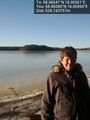
READ THIS FIRST
Do not attempt this if you are not prepared! Spring ice is really dangerous. I have cut holes in the ice and swum in 0°C water before, I was wearing ice safety picks at all times, I was wearing a wet suit in case I went through the ice, I had checked the ice map beforehand and I had a person on stand-by on land watching over me.
Location
On the ice 50m from a tiny island, 530 m from the nearest island reachable by car, Herrö, near Muskö. Closest island with a name south of the hash was Björkholmen.
Participants
- Carl-Johan
- TheNuclearScientist for safety
Plans
I had been watching for hashes in Utö, Sweden for a long time. It is like 99% Baltic Sea so it is really a long shot to try to get a hash in here. But on Thursday I saw that the coords where up in the NW corner, fairly close to land, like 500 or so, and inside the ring of outer islands. The weather has been thawing for some time now but it was really cold in February so this might be reachable with a lot of preparation. I checked the Icemap from SMHI and it said 5-15 cm, rotten ice. Rotten ice can mean anything so it could be safe or totally unsafe, only way to be sure was to check it out. Ice types explained here.
Expedition
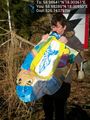
My dad and I headed off some time after 14 in the afternoon towards Muskö, the secret island. We stopped at Biltema and bought some more Orange™ and an inflatable kiddy boat, just in case it wasn't all ice. Gotta be prepared. We continued down to the islands and turned of at a tiny gravel road on Herrö, the "Gentleman Island". After a twisty muddy road we got to the closest place on land. Parked away from the house that was closest to the water, got my gear and went around their yard to the water.
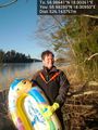
The ice looked pretty good from here, not open water as had been the case under the bridge that took us here, but that was streaming water and this looked promising. Still, the first 2 m was just broken patches of ice so the hardest part looked like the first step. We found a nice plank to use and some wood to make a makeshift gangplank halfway out to the main ice sheet. I got into my wet suit, put the phone in a waterproof case and got out my ice safety picks while dad was blowing up the kiddy boat. After all, I had no idea of the conditions further out and it was still 530 m to the hash.

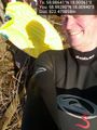
I put the plank and the other wood onto the ice and laid down on the kiddy boat on my stomach and started inching my way to the real ice edge before the ice I was on sank. The kiddy boat was the worst ever and leaked from a hole in the bottom so it was only useful for those 2m. Throw that shit away. Fucking Biltema quality. 5€ down the drain. The ice seemed solid and okay. Not so rotten as I had thought. You could still see lots of bubbles in it and it was not as solid as the nice blue ice you really want but it didn't give at all when you jumped on it. Still I was cautious. I ventured further and further from land, walking upright, using the plank to hammer on the ice every few meters. I had my IceBug shoes with spikes underneath so footing was not a problem. After 100m I realized I had forgotten my Orange™ but I didn't have a free hand anyway so we decided to skip it. Stopped at 200m out and took a pic and surveyed everything. The ice was roughly 10cm and I could not find any real weakness in it.
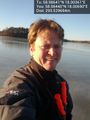
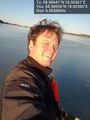
I continued onward to the Island I knew the hash was close to, checking the ice all the time. You fool yourself into thinking that the dark parts are the thin parts but actually the dark parts are the strong parts and the lite parts are the weak parts of the ice. I was getting closer and closer. I picked up the phone when I had 30m to go and navigated straight to the hash. Sat down and took some nice pics.
And yes, those are rubber gloves in case I needed to stick my hand into the freezing water.

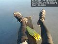
After uploading all pics I started heading back exactly the same way I came. I knew that that ice had held my weight going out so I could walk faster on the way back. Got to the edge of the ice and snapped a pic of dad and I put the phone on a stick he was holding out so he could snap a pic of me. I used the plank and the stick to traverse the last 1.5m which of course was the hardest part, and the back on dry land, and I was completely dry as well.
Got out of my wet suit as my dad walked back to the car. He mentioned something about it probably was worse standing on land watching me than being on the ice, he had no idea of the ice condition out there. As I got back to the house we'd walked around the neighbor was there chatting with my dad. He was a really nice chap but couldn't really understand why I was doing what I was doing. He had thought I was out ice fishing. We laughed a bit and then back to the car and back to Stockholm.
Tracklog
map of my ice adventures.
Photos
530 m rotten ice @58.9828,18.0095
Wet suit on @58.9828,18.0094
Dad blowing up the kiddy boat @58.9828,18.0095
With a kiddy boat in hand, what could possibly go wrong? @58.9828,18.0095
300m left @58.9844,18.0069
Deflowered @58.9865,18.0036
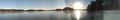
Panorama toward the sun @58.9864,18.0036

Panorama the other way @58.9864,18.0036
Wet suit, Icebug shoes and rubber gloves. @58.9864,18.0036
There is where I came from. @58.9864,18.0036
Last step is the worst @58.9826,18.0093
Neighbor Wredenborg @58.9817,18.0098


Achievements
Carl-Johan earned the Graticule Unlocked Achievement
|
Carl-Johan earned the Water geohash achievement
|
Carl-Johan earned the Walking on water geohash achievement
|
Carl-Johan earned the One with Nature Geohash Achievement
|
Carl-Johan completed the Minesweeper Geohash achievement
|