Difference between revisions of "2012-03-08 47 -40"
imported>Wolkenjaeger (→Expedition) |
imported>Fippe (Location) |
||
| (12 intermediate revisions by 2 users not shown) | |||
| Line 14: | Line 14: | ||
}} | }} | ||
| − | + | ||
__NOTOC__ | __NOTOC__ | ||
== Location == | == Location == | ||
| Line 20: | Line 20: | ||
== Participants == | == Participants == | ||
| − | Me (wolkenjaeger), 11 other crew members and 178 passengers. Well, at the end only 4 people were knowing that we tried to get a geohash. | + | Me ([[User:wolkenjaeger]]), 11 other crew members and 178 passengers. Well, at the end only 4 people were knowing that we tried to get a geohash. |
== Plans == | == Plans == | ||
| Line 28: | Line 28: | ||
What a great day to go flying. Clear skys and a great crew. That's the recipe for a successful and fun commercial flight. | What a great day to go flying. Clear skys and a great crew. That's the recipe for a successful and fun commercial flight. | ||
| − | As we don't | + | As we don't receive any good GPS signals in the cockpit ([http://en.wikipedia.org/wiki/Faraday_cage Faraday Cage?]) I had to check the route manually for any geohashes enroute, which is quite some work as we are crossing a [[graticule]] in around 10 minutes average and my job is not just sitting there and check for random coordinates. Second problem is a pure air safety one: we just cannot go off our IFR flightplan, which means the hash needs to be right on our track. |
| + | |||
| + | The first point I wanted to test was in the [[graticule]] 47,-15 - that was the time I quickly learned that our first possibility was in [[graticule]] 47,-40. So I inserted a pilot waypoint "HASH2" into our flight management computer ([http://en.wikipedia.org/wiki/Flight_management_system FMS]) to check our progress enroute. | ||
| + | |||
| + | At the time of overflying the waypoint we slightly navigated off the track F to get get as close as possible. The commander took care of the flying as I took the proving photographs and the group photo. | ||
| + | Additional Information: On the NAT system, you can go off track at a maximum of 2nm to the right, the point was within 1nm, we were flying 1nm right of the track anyway according to procedures so it did not take a lot to overfly the point. | ||
| + | |||
| + | On the flight back, I did not chase any geohashes, as I wanted to check on my first geohash first. Did I do everything correct? | ||
| + | |||
| + | On the next morning, after sleeping my jetlag out, I checked on the correctness of my first geohash and there it was: a huge mistake. | ||
| + | I didn't read the rules well, and the geohash in the [[graticule]] 47,-40 was not N 47°57.319 W 40°27.327, but N 47°24.784 W 40°20.498!!! | ||
| + | Noooo!!!! Where was my mistake? | ||
| + | |||
| + | [[30W_Time_Zone_Rule]] gave the solution. So that was my first expedition and my first contact with geohashing. | ||
| + | However I hope you guys don't do the same mistake. | ||
| + | |||
| + | I will be back. | ||
== Tracklog == | == Tracklog == | ||
| Line 35: | Line 51: | ||
== Photos == | == Photos == | ||
<gallery perrow="5"> | <gallery perrow="5"> | ||
| − | Image:P1060021-LR 800.jpg | + | Image:P1060021-LR 800.jpg | My first try: "HASH" in the [[graticule]] 48,-15 |
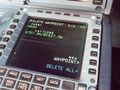
| − | Image:P1060024-LR 800.jpg | + | Image:P1060024-LR 800.jpg | We are here, custom waypoint "HASH2" with a lateral distance of 0.0nm and the GPS (left) showing the coordinates. |
| − | Image:P1060027-LR 800.jpg | + | Image:P1060027-LR 800.jpg | We did it! |
</gallery> | </gallery> | ||
== Achievements == | == Achievements == | ||
{{#vardefine:ribbonwidth|800px}} | {{#vardefine:ribbonwidth|800px}} | ||
| − | |||
| + | {{Blinded by Science | ||
| + | | latitude = 47 | ||
| + | | longitude = -40 | ||
| + | | date = 2012-03-08 | ||
| + | | reason = geohash 30W rule confusion | ||
| + | | name = wolkenjaeger | ||
| + | }} | ||
| − | |||
| − | |||
| − | |||
| − | + | [[Category:Expeditions]] | |
| − | |||
| − | [[Category: | ||
| − | |||
| − | |||
| − | |||
| − | |||
[[Category:Expeditions with photos]] | [[Category:Expeditions with photos]] | ||
| − | + | [[Category:Coordinates not reached]] | |
| − | |||
| − | |||
| − | |||
| − | |||
| − | [[Category:Coordinates reached]] | ||
| − | |||
| − | + | [[Category:Not reached - Technology]] | |
| − | + | {{location|XI}} | |
| − | |||
| − | |||
| − | |||
| − | [[Category:Not reached - Technology]] | ||
| − | |||
| − | |||
Latest revision as of 13:48, 19 May 2019
| Thu 8 Mar 2012 in 47,-40: 47.4130725, -40.3416416 geohashing.info google osm bing/os kml crox |
Location
Somewhere over the North Atlantic, (almost) on track F of the NAT on this day.
Participants
Me (User:wolkenjaeger), 11 other crew members and 178 passengers. Well, at the end only 4 people were knowing that we tried to get a geohash.
Plans
Well, I learned about geohashing a few days ago in connection with the 2012-02-26_global. So I prepared myself to chase the airways for geohashes from our flight from Zürich to New York.
Expedition
What a great day to go flying. Clear skys and a great crew. That's the recipe for a successful and fun commercial flight.
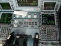
As we don't receive any good GPS signals in the cockpit (Faraday Cage?) I had to check the route manually for any geohashes enroute, which is quite some work as we are crossing a graticule in around 10 minutes average and my job is not just sitting there and check for random coordinates. Second problem is a pure air safety one: we just cannot go off our IFR flightplan, which means the hash needs to be right on our track.
The first point I wanted to test was in the graticule 47,-15 - that was the time I quickly learned that our first possibility was in graticule 47,-40. So I inserted a pilot waypoint "HASH2" into our flight management computer (FMS) to check our progress enroute.
At the time of overflying the waypoint we slightly navigated off the track F to get get as close as possible. The commander took care of the flying as I took the proving photographs and the group photo. Additional Information: On the NAT system, you can go off track at a maximum of 2nm to the right, the point was within 1nm, we were flying 1nm right of the track anyway according to procedures so it did not take a lot to overfly the point.
On the flight back, I did not chase any geohashes, as I wanted to check on my first geohash first. Did I do everything correct?
On the next morning, after sleeping my jetlag out, I checked on the correctness of my first geohash and there it was: a huge mistake. I didn't read the rules well, and the geohash in the graticule 47,-40 was not N 47°57.319 W 40°27.327, but N 47°24.784 W 40°20.498!!! Noooo!!!! Where was my mistake?
30W_Time_Zone_Rule gave the solution. So that was my first expedition and my first contact with geohashing. However I hope you guys don't do the same mistake.
I will be back.
Tracklog
n/a
Photos
My first try: "HASH" in the graticule 48,-15
We are here, custom waypoint "HASH2" with a lateral distance of 0.0nm and the GPS (left) showing the coordinates.
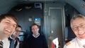
We did it!


Achievements
wolkenjaeger earned the Blinded by Science Consolation Prize
|