2012-03-12 52 1
From Geohashing
Revision as of 21:01, 12 March 2012 by imported>Sourcerer (→Achievements)
| Mon 12 Mar 2012 in 52,1: 52.2660062, 1.0786461 geohashing.info google osm bing/os kml crox |
Location
On a public footpath near Mendlesham 12km south of Diss, Norfolk, UK. Logged at Wikiloc.
Participants
Expedition
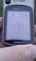
- Arrived. -- Sourcerer @52.2660,1.0787 17:40, 12 March 2012 (GMT)
This was a very easy expedition involving a three mile walk and a short drive to reach the area. The hashpoint was just off a public footpath. As this footpath was missing from OpenStreetMap, I have added it.
Tracklog
Logged at Wikiloc.
Photos
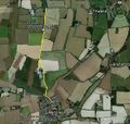
Google Earth Track
The Evidence

View by the hashpoint.
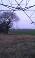
View by the hashpoint.
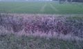
Hashpoint in the ditch.


Achievements
Sourcerer earned the OpenStreetMap achievement
|