Difference between revisions of "2012-03-14 48 11"
imported>The T-Man (Created page with "{{subst:Expedition |lat = 48 |lon = 11 |date = 2012-03-14 }}") |
imported>FippeBot m (Location) |
||
| (12 intermediate revisions by 2 users not shown) | |||
| Line 1: | Line 1: | ||
| − | |||
| − | |||
| − | |||
| − | |||
| − | |||
| − | |||
| − | |||
| − | |||
| − | |||
| − | |||
{{meetup graticule | {{meetup graticule | ||
| lat=48 | | lat=48 | ||
| Line 15: | Line 5: | ||
}} | }} | ||
| − | + | ||
__NOTOC__ | __NOTOC__ | ||
== Location == | == Location == | ||
| − | + | On a Meadow at the edge of Bergkirchen, a beautiful small village near München, Germany. | |
== Participants == | == Participants == | ||
| − | + | [[User:DerFlob|DerFlob]], [[User:The_T-Man|The_T-Man]] and [[User:Scherzkeks|Johanna]], his girlfriend. | |
== Plans == | == Plans == | ||
| − | + | The plan was to get into the car, pick up Johanna at her workplace and then go to the hashpoint and back again. | |
== Expedition == | == Expedition == | ||
| − | + | At around 3:30 p.m., The_T-Man and DerFlob drove to pick up The_T-Man's girlfriend at work who then took over as driver since it was her car. The geohasher's 30 km trip was slowed down a bit by a rather large traffic jam on the major roads leaving München towards the West caused by an accident in a tunnel. The point was located on a meadow at the southern edge of Bergkirchen, a small village on the southern edge of München. Luckily, both finding a parking spot and access to the hashpoint proved not to be of any difficulty. | |
| + | To celebrate the occasion, Johanna had baked a totally awesome mixed berry pie. Together with a blanket, dishes and some hot coffee from DerFlob, a nice picnic was had surrounded by village, sunset, a little stream and some pigs in a safe distance. The way back was significantly more comfortable and only slowed down by some short periods of congested roads. | ||
| − | == | + | == Photos == |
| − | |||
| − | = | + | <gallery perrow="6"> |
| − | + | Image:2012-03-14-TMan-01.jpg | In the traffic jam, about 30 minutes before reaching the spot | |
| − | Image: | + | Image:2012-03-14-TMan-02.jpg | At the spot |
| − | -- | + | Image:2012-03-14-TMan-03.jpg | The coordinates |
| − | + | Image:2012-03-14-TMan-04.jpg | [[User:The_T-Man|The_T-Man]] (left) and [[User:DerFlob|DerFlob]] (right) at the hashpoint with the village in the background | |
| + | Image:2012-03-14-TMan-05.jpg | The picnic with Johanna's pie and DerFlob's coffee | ||
| + | Image:2012-03-14-TMan-06.jpg | Now how could Bergkirchen ("Mountain church") have possibly gotten its name? | ||
| + | Image:2012-03-14-TMan-07.jpg | DerFlob enjoying some π | ||
| + | Image:2012-03-14-TMan-08.jpg | The picnic was accompanied by a beautiful sunset | ||
| + | Image:2012-03-14-TMan-09.jpg | You could see a thin layer of spiderwebs in the dwindling light | ||
| + | Image:2012-03-14-TMan-10.jpg | The_T-Man feasting on the π | ||
| + | Image:2012-03-14-TMan-11.jpg | 1* π remaining | ||
| + | Image:2012-03-14-TMan-12.jpg | These fellows were about 50 metres away from us | ||
| + | Image:2012-03-14-TMan-13.jpg | One of the πgs | ||
| + | Image:2012-03-14-TMan-14.jpg | The pigs' view of the geohashers | ||
| + | Image:2012-03-14-TMan-15.jpg | And yet another beautiful view discovered through geohashing | ||
| + | Image:2012-03-14-TMan-16.jpg | The stream south of the hashpoint | ||
| + | Image:2012-03-14-TMan-17.jpg | Our vehicle of choice | ||
| + | Image:2012-03-14-TMan-18.jpg | The illuminated [http://en.wikipedia.org/wiki/Allianz_Arena Allianz Arena] the day after Bayern Munich's awesome 7:0 victory over Basel FC | ||
</gallery> | </gallery> | ||
== Achievements == | == Achievements == | ||
{{#vardefine:ribbonwidth|800px}} | {{#vardefine:ribbonwidth|800px}} | ||
| − | + | {{pie|latitude=48|longitude=11|date=2012-03-14|name=[[User:DerFlob|DerFlob]], [[User:The_T-Man|The_T-Man]], [[User:Scherzkeks|Johanna]]|pastry=mixed berry pie|pi=Pi-Day 2012}} | |
| + | {{Picnic | latitude = 48 | longitude = 11 | date = 2012-03-14 | name = [[User:DerFlob|DerFlob]], [[User:The_T-Man|The_T-Man]], [[User:Scherzkeks|Johanna]] | image =2012-03-14-TMan-05.jpg | food = pie & coffee }} | ||
| − | |||
| − | |||
| − | |||
| − | |||
| − | |||
| − | |||
| − | |||
| − | |||
| − | |||
| − | |||
| − | |||
| − | |||
| − | |||
[[Category:Expeditions with photos]] | [[Category:Expeditions with photos]] | ||
| − | [[Category:Expeditions | + | [[Category:Expeditions]] |
| − | |||
| − | |||
| − | |||
| − | |||
[[Category:Coordinates reached]] | [[Category:Coordinates reached]] | ||
| − | + | {{location|DE|BY|DAH}} | |
| − | |||
| − | |||
| − | |||
| − | |||
| − | |||
| − | |||
| − | |||
| − | |||
| − | |||
Latest revision as of 02:54, 13 August 2019
| Wed 14 Mar 2012 in 48,11: 48.2537601, 11.3619844 geohashing.info google osm bing/os kml crox |
Location
On a Meadow at the edge of Bergkirchen, a beautiful small village near München, Germany.
Participants
DerFlob, The_T-Man and Johanna, his girlfriend.
Plans
The plan was to get into the car, pick up Johanna at her workplace and then go to the hashpoint and back again.
Expedition
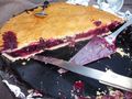
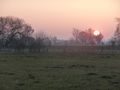
At around 3:30 p.m., The_T-Man and DerFlob drove to pick up The_T-Man's girlfriend at work who then took over as driver since it was her car. The geohasher's 30 km trip was slowed down a bit by a rather large traffic jam on the major roads leaving München towards the West caused by an accident in a tunnel. The point was located on a meadow at the southern edge of Bergkirchen, a small village on the southern edge of München. Luckily, both finding a parking spot and access to the hashpoint proved not to be of any difficulty. To celebrate the occasion, Johanna had baked a totally awesome mixed berry pie. Together with a blanket, dishes and some hot coffee from DerFlob, a nice picnic was had surrounded by village, sunset, a little stream and some pigs in a safe distance. The way back was significantly more comfortable and only slowed down by some short periods of congested roads.
Photos
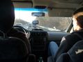
In the traffic jam, about 30 minutes before reaching the spot
At the spot
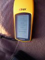
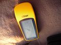
The coordinates
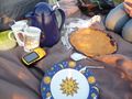
The picnic with Johanna's pie and DerFlob's coffee
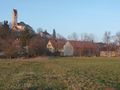
Now how could Bergkirchen ("Mountain church") have possibly gotten its name?
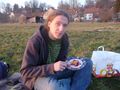
DerFlob enjoying some π
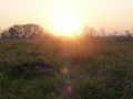
The picnic was accompanied by a beautiful sunset

You could see a thin layer of spiderwebs in the dwindling light
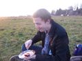
The_T-Man feasting on the π
1* π remaining
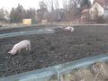
These fellows were about 50 metres away from us

One of the πgs
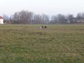
The pigs' view of the geohashers
And yet another beautiful view discovered through geohashing
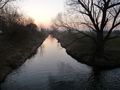
The stream south of the hashpoint

Our vehicle of choice
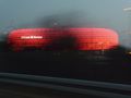
The illuminated Allianz Arena the day after Bayern Munich's awesome 7:0 victory over Basel FC


Achievements
DerFlob, The_T-Man, Johanna earned the Pie Geohash Achievement
|
DerFlob, The_T-Man, Johanna earned the Picnic achievement
|